Ehrhardt in Bamberg County, South Carolina — The American South (South Atlantic)
Battle of Rivers' Bridge
Feb. 2-3, 1865
The Salkehatchie River Crossings
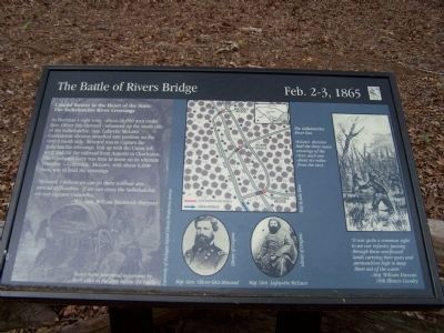
As Sherman's right wing- about 28,000 men underGen. Oliver Otis Howard- advanced up the south side of the Salkehatchie, Gen. Lafayette McLaws' Confederate division marched into position on the river's north side. Howard was to capture the Salkehatchie crossings, link up with the Union left wing and cut the railroad from Augusta to Charleston. The combined force was then to move on its ultimate objective --Columbia. McLaws, with about 6,000 men was to hold the crossing.
"Howard, I believe we can go there without any serious difficulties. If we can cross the Salkehatchie, we can capture Columbia."
- Maj. Gen. William Tecumseh Sherman
Erected by South Carolina State Park Service.
Topics. This historical marker is listed in this topic list: War, US Civil.
Location. 33° 3.136′ N, 81° 6.005′ W. Marker is in Ehrhardt, South Carolina, in Bamberg County. Marker can be reached from SC-S-5-8, on the right when traveling south. Located in the Rivers Bridge State Park, a mile south of SC-S-5-31. Touch for map. Marker is in this post office area: Ehrhardt SC 29081, United States of America. Touch for directions.
Other nearby markers. At least 8 other markers are within walking distance of this marker. A different marker also named Battle of Rivers' Bridge (within shouting distance of this marker); a different marker also named Battle of Rivers' Bridge (within shouting distance of this marker); a different marker also named Battle of Rivers' Bridge (within shouting distance of this marker); a different marker also named Battle of Rivers' Bridge (about 400 feet away, measured in a direct line); a different marker also named Battle of Rivers' Bridge (about 600 feet away); a different marker also named Battle of Rivers' Bridge (about 600 feet away); a different marker also named Battle of Rivers' Bridge (about 700 feet away); a different marker also named Battle of Rivers' Bridge (approx. 0.2 miles away). Touch for a list and map of all markers in Ehrhardt.
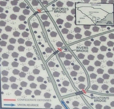
Regarding Battle of Rivers' Bridge. On the left under the text is a drawing showing Heavy rains hampered movement by both sides in the days before the battle. In the upper center is a map by Julie Elam detailing The Salkehatchie River line: McLaws' division held the three main crossings of the river,each one about six miles from the next. Below it are portraits
of Maj. Gen. Oliver Otis Howard and Maj. Gen. Lafayette McLaws (from the Library of Congress). On the right is a drawing captioned: "It was quite a common sight to see our infantry passing through these overflowed lands carrying their guns and ammunition high to keep them out of the water."- Maj. William Duncan 10th Illinois Cavalry.
Credits. This page was last revised on June 16, 2016. It was originally submitted on April 28, 2008, by Mike Stroud of Bluffton, South Carolina. This page has been viewed 1,646 times since then and 25 times this year. Photos: 1, 2. submitted on April 28, 2008, by Mike Stroud of Bluffton, South Carolina. 3. submitted on April 29, 2008, by Mike Stroud of Bluffton, South Carolina. • Craig Swain was the editor who published this page.


