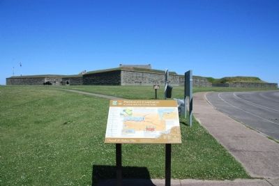
Oswego in Oswego County, New York — The American Northeast (Mid-Atlantic)
Prideaux's Campaign
A Long Route to Victory
— French and Indian War —
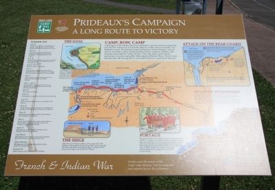
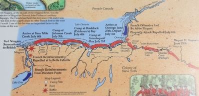
Campaigns in the North American wilderness required extensive planning and massive manpower to reach the objective safely and successfully. For Prideaux's army, the distance from Fort Stanwix to Fort Niagara was not easy to overcome as they transported their food, weapons, shelters, and cannons across half the colony of New York. The army used natural waterways as much as possible, following the Mohawk River, Wood Creek, Oneida Lake, the Oswego River, and Lake Ontario to reach their objective.
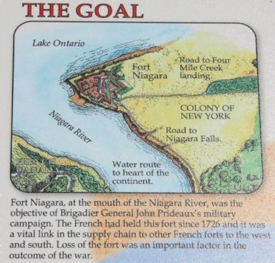
The Goal
Fort Niagara, at the mouth of the Niagara River, was the objective of Brigadier General John Prideaux's military campaign. The French had held this fort since 1726 and it was a vital link in the supply chain to other French forts to the west and south. Loss of the fort was an important factor in the outcome of the war.
Into the Wilderness
As General Prideaux's army traveled to Fort Niagara, they were traveling along waterways and portage routes that led them further from any source of supply or reinforcement. They had to be self-sufficient, relying on only the resources they had with them, and trusting that the troops left at Oswego would be able to protect their rear flank and provide a secure base of operations for future needs.
Portage
During the march to Fort Niagara, there were times when the soldiers were required to transport military supplies and boats from one waterway to the next, overland. A primary portage point was at Fort Stanwix where all supplies and munitions were transported from the Mohawk River, across the Oneida Carry to Wood Creek, which led to Oneida Lake and eventually the Onondaga (or Oswego) River to Lake Ontario.
The Siege
After leaving Fort Stanwix (Rome, NY) on June 15th, 1759, Prideaux's army finally arrived at Four Mile Creek on July 6th. Once there, the British immediately began to prepare for the advance and siege on the French Fort Niagara.
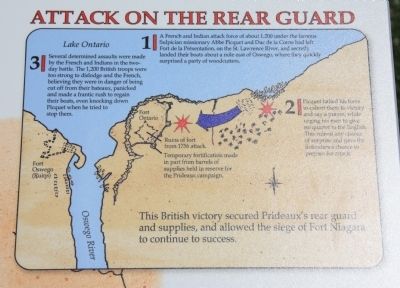
Attack on the Rear Guard
1]
A French and Indian attack force of about 1,200 under the famous Sulpician missionary Abbe Picquet and Duc de la Corne had left Fort de la Présentation, on the St. Lawrence River, and secretly landed their boats about a mile east of Oswego, where they quickly surprised a party of woodcutters.
2]
Picquet halted his force to exhort them to victory and say a prayer, while urging his men to give no quarter to the English. This ruined any chance of surprise and gave the defenders a chance to prepare for
Photographed By Dale K. Benington, July 10, 2014
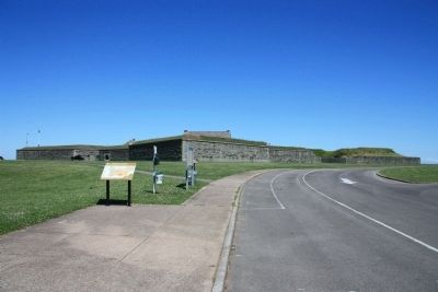
2. Prideaux's Campaign Marker
View of the historical marker situated in the Fort Ontario State Historic Site, in front of Fort Ontario, along the western edge of the fort's visitor's parking lot, and near the beginning of the walkway that leads up to the entrance of the fort.
3]
Several determined assaults were made by the French and Indians in the two-day battle. The 1,200 British troops were too strong to dislodge and the French, believing they were in danger of being cut off from their bateaux, panicked and made a frantic rush to regain their boats, even knocking down Picquet when he tried to stop them.
This British victory secured Prideaux's rear guard and supplies, and allowed the siege of Fort Niagara to continue to success.
Summer 1759
January 29
Orders issued to raise bateaux men for expedition
Early February
44th Regiment of Foot begins to march from winter quarters on Long Island.
Late March
46th Regiment of Foot begins to travel up the Mohawk River to Fort Stanwix (present-day Rome, NY).
April 11
46th Regiment of Foot arrives at Fort Stanwix, the departure point for the expedition.
May 5
Major General Jeffery Amherst issues orders relative to the expedition and names Brigadier General John Prideaux as expedition commander.
May 23
44th Regiment of Foot begins travel up the Mohawk River heading for Fort Stanwix.
May 31
General Prideaux,
along with the New York Regiment, embarks on the Mohawk River bound for Fort Stanwix.
June 14
Most of General Prideaux's force is encamped at Fort Stanwix.
June 15
Army begins to march from Fort Stanwix for Oneida Lake.
June 27
Army arrives at Oswego.
July 1 - July 4
Army embarks on Lake Ontario and arrives at Braddock Bay (named Prideaux Bay at the time, after the commander).
July 5
Army embarks on Lake Ontario and arrives at Johnson Creek (named for Sir William Johnson).
July 6
Army embarks on Lake Ontario and arrives at Four Mile Creek within four miles of Fort Niagara. Picquet's attack on rear guard in Oswego repelled.
July 6 - July 25
British lay siege to Fort Niagara.
July 20
General Prideaux walks in front of his own mortar fire and is killed, Sir William Johnson assumes command of army.
July 24
French relief force from western posts is defeated at la Belle Famille (present-day Youngstown, NY) sealing the fate of Fort Niagara.
July 25
Captain Pierre Pouchot, commandant of Fort Niagara, surrenders the post to Sir William Johnson and British take possession of the fort.
Erected by
Great Lakes Seaway Trail.
Topics and series. This historical marker is listed in these topic lists: Colonial Era • Native Americans • War, French and Indian. In addition, it is included in the Great Lakes Seaway Trail National Scenic Byway series list. A significant historical month for this entry is January 1861.
Location. 43° 27.868′ N, 76° 30.433′ W. Marker is in Oswego, New York, in Oswego County. Marker is on East 4th Street north of Show Park Road, on the left when traveling north. This historical marker is a panel that is situated on the grounds of the Fort Ontario State Historic Site, very near the western edge of the parking lot, and very close to the beginning of the footpath that leads to the entrance of Fort Ontario. Touch for map. Marker is in this post office area: Oswego NY 13126, United States of America. Touch for directions.
Other nearby markers. At least 8 other markers are within walking distance of this marker. African Troops at Fort Ontario (within shouting distance of this marker); Fort Ontario (about 400 feet away, measured in a direct line); Holocaust Survivors (approx. ¼ mile away); Fort Ontario State Historic Site (approx. ¼ mile away); British Invasion (approx. ¼ mile away); The Post Cemetery (approx. ¼ mile away); Those Buried At Fort Ontario (approx. ¼ mile away); From the Hearth of America Come the Heart of America (approx. 0.3 miles away). Touch for a list and map of all markers in Oswego.
Credits. This page was last revised on June 16, 2016. It was originally submitted on July 26, 2014, by Dale K. Benington of Toledo, Ohio. This page has been viewed 896 times since then and 47 times this year. Photos: 1, 2, 3, 4, 5, 6. submitted on July 26, 2014, by Dale K. Benington of Toledo, Ohio.
