Harkers Island in Carteret County, North Carolina — The American South (South Atlantic)
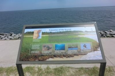
Estuaries of the Sound
These three sounds, and the estuary they create, are sheltered by the barrier islands of the Outer Banks, including the islands within Cape Lookout and Cape Hatteras National Seashores.
The estuary created by the Outer Banks is rivaled in size only by that of the Chesapeake Bay.
Plants and creatures from across the food web thrive in the estuaries. The rich sea life is an important source of food and income for regional communities.
(captions)
Cordgrass provides food and shelter for birds, crabs, crustaceans, and mollusks.
The sharp claws of a blue crab tear apart shrimp, worms, and even other crabs.
The estuary enclosed by the Outer Banks is a nursery and home to many fish.
Tricolored herons stab their long beaks into the muddy waters to feed on crabs, fish, and insects.
Watch for osprey flying over open water, searching for fish to eat.
Erected by Cape Lookout National Seashore.
Topics. This historical marker is listed in these topic lists: Environment • Waterways & Vessels.
Location. 34° 41.118′ N, 76° 31.554′ W. Marker is on Harkers Island, North Carolina, in Carteret County. Marker can be reached from Island Road (County Route 1335) east of Cape Point Road, on the left when traveling east. The marker is located on the grounds of the Cape Lookout National Seashore Visitor Center. Touch for map. Marker is in this post office area: Harkers Island NC 28531, United States of America. Touch for directions.
Other nearby markers. At least 8 other markers are within 2 miles of this marker, measured as the crow flies. Horizon of Islands (a few steps from this marker); Protecting People and Ships (a few steps from this marker); Olive Thurlow Anchor (within shouting distance of this marker); Harkers Island Visitor Center at Cape Lookout National Seashore (about 300 feet away, measured in a direct line); Fort Hancock (about 600 feet away); Rain Gardens (approx. 0.2 miles away); Cisterns (approx. 0.2 miles away); In Honor and Rememberance (approx. 1.6 miles away). Touch for a list and map of all markers in Harkers Island.
Also see . . . Cape Lookout National Seashore. National Park Service (Submitted on September 1, 2014.)
Credits. This page was last revised on June 16, 2016. It was originally submitted on August 31, 2014, by Don Morfe of Baltimore, Maryland. This page has been viewed 356 times since then and 10 times this year. Photos: 1, 2. submitted on August 31, 2014, by Don Morfe of Baltimore, Maryland. • Bernard Fisher was the editor who published this page.

