La Porte in LaPorte County, Indiana — The American Midwest (Great Lakes)
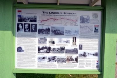
The Lincoln Highway
America's First Paved Coast-to-Coast Highway
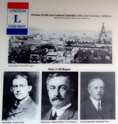
How It All Began
The time was 1912. One million plus motor vehicles were in use in America, primarily in urban settings. To that time only eight recorded motor car travelers had ventured a trip across America. Paved roads were rare beyond city limits and interurban automobile travel was difficult and nearly impossible after heavy rain. Of approximately 2,199,600 miles of rural road only 190,476 miles (8.66%) had improved surfaces of gravel, sand-clay, brick, shells, oiled earth, or macadam. All improvements were through local efforts. East of the Mississippi River roads were prevalent, but west of the Mississippi, road conditions deteriorated dramatically. America’s highway system was a disorganized series of roads from place to place and from town to town via pioneer trails, Native American trails and Pony Express routes. Railroads and steamships were the principal modes of long distance travel.
Auto manufacturers continued to produce automobiles and component manufacturers were supplying parts for the car makers and for repair beyond the factory. Citizens had vehicles to drive but little opportunity or incentive to travel by automobile from town to town, let alone far from town.
Indiana-born Carl Fisher, owner of Prest-O-Lite Corporation, maker of carbide fueled auto lamps, realized the need for improved roads to provide interurban travel. He conceived the idea of a “Coast to Coast Rock Road”. Fisher also had a great business sense and so, invited auto manufacturers and automotive parts suppliers to a banquet at the Athenaeum (German House) in Indianapolis to present his idea.
At that meeting Fisher encouraged donations to the venture and received pledges of approximately one million dollars, $300,000 of which was donated by Frank Seiberling, President of Goodyear Tire Company of Akron, Ohio.
Henry Joy, Packard Motor Car Company President, proposed the road be named “The Lincoln Highway” in honor of Abraham Lincoln, our nation’s 16th President. On July 1, 1913 the Lincoln Highway Association was established and Henry Joy became President. On July 7, Henry Joy with a Packard Twin Six began a tour from Detroit to San Francisco to decide upon a direct route.
On July 1, Carl Fisher led a group of motorists in seventeen touring cars followed by two trucks carrying spare tires and supplies from Indianapolis to San Francisco to solidify the route and demonstrate the need for an improved trans-continental paved highway. The thirty four day trip generated a wealth of publicity and excitement.
By 1915 the official route of the Lincoln Highway was established and The Complete Official Road Guide was published. The Lincoln Highway from Times Square in New York, traversed thirteen states and ended at Lincoln Park in San Francisco, California. This route ran 3,389 miles and was a true Coast-to-Coast “continuous improved highway from Atlantic to Pacific.” Existing roadbeds were chosen, along with new sections to be built by local supporters and governments to complete the path.
The time was right. San Francisco, devastated by the great earthquake of 1906 was rebuilt, alive and well and was hosting the 1915 Panama Pacific International Exposition, a World’s Fair commemorating the recent opening of the Panama Canal and the four hundredth anniversary of Vasco de Balboa’s discovery of the Pacific Ocean. Motorists had good reason to venture west on the Lincoln Highway.
Between 1912 and 1915 much took place to promote the Highway’s growth and popularity across the land. For example:
- The Lincoln Highway Association had established and marked a definite route.
- The Complete Official Road Guide of 1915 provided travel information from state to state noting hotels, fuel stops, travel supply locations and points of interest. The guide offered a list of supplies recommended for the trip including shovel, rope, block and tackle, spare tires, skid chains, tent, cook stove, and large canvas water bags.
- The Association later published strip maps of each state, seventeen in all, showing the towns through which to travel and the distance between them.
- In cities and towns along the way the LH Association designated a Consul, an individual who was available to provide local information for supplies, repair, meals, lodging, and road conditions in both directions. The motorist could verify his/her mileage and reset the odometer to zero if desired, knowing the distance to the next point.
- The familiar red, white and blue bands with large blue L in the white field on telephone poles assured the Lincoln Highway traveler of the correct route. A painted arrow showed which way to turn or to continue straight ahead.
- Seedling Miles, mile long stretches of smooth concrete road, strategically constructed between towns pressured communities at both ends to build better roads.
roads too frail for heavy trucks and too narrow for efficient movement of military personnel and equipment. “Ike’s” report gave rise to what became “The Ideal Section”, and as President he supported the building of the U.S. Interstate highway system.
The Ideal Section was a 1.3 mile section of highway constructed from 1921 to 1923 between Dyer and Schererville, Indiana along the Lincoln Highway. In 1920 the LHA, determined to establish a highway that would for many years survive heavy traffic under variable weather extremes, convened a group of 17 of the nation’s foremost highway engineers to design such a highway. The result was the Ideal Section, a 40-foot wide concrete pavement 10 inches thick, steel reinforced, and 4 lanes wide for two-way traffic. The original road survived until 1997 when that section of U.S. 30 between the Illinois state line and Indianapolis Boulevard was removed and rebuilt to create a wider highway.
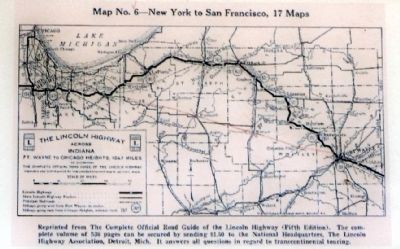
The map above is one example of seventeen such Strip Maps published by the Lincoln Highway Association. The maps directed travelers along the 1915 route from Times Square in New York City, through thirteen states and four state capitals to its terminus in San Francisco at the Panama Pacific International Exposition.
The bold line shows the original LH route through Indiana. The north route through
South Bend was considered more “vehicle friendly” than that to the south. As auto travel increased road quality improved. In 1925 the LHA changed the alignment, represented by the red line from Valparaiso to Fort Wayne. On November 11, 1926 the American Association of State Highways established the current national highway numbering system and the Lincoln Highway across most of the Midwest became U.S. 30.
Of the thirteen Indiana counties through which the Lincoln Highway passes, La Porte County is one of four the claims the history of both (1915 and 1926) alignments. Over the years the alignments have been modified to provide smoother curves and to bypass towns. Most of both LH alignments in Indiana still exist in well maintained condition. The familiar red, white and blue Lincoln Highway signs erected by the Indiana Lincoln Highway Association, guide travelers through the countryside where they may stop at a friendly diner for a bite to eat or simply enjoy the scenery.
To assist travelers the LH Association set up Lincoln Highway Control Stations in cities and towns along the route. The Courthouse was La Porte’s Control Station. Judge John C. Richter served as judge on the La Porte Circuit Court and also served as the La Porte Lincoln Highway Consult. He answered questions and provided travel information about the route.
To promote the
Lincoln Highway and draw motorists through towns the association encouraged towns to rename their main streets Lincoln Way.
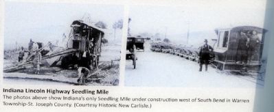
Another encouragement to travel was the Seedling Mile, a sixteen foot wide one mile long stretch of concrete paved road between towns to demonstrate the joys of smooth open-road motoring. Portland Cement and other concrete companies donated the concrete and local business and communities provided the manpower and equipment. Indiana received funding for a Seedling Mile in 1916. It was constructed about seven miles east of New Carlisle on what is now U.S. 20 just west of South Bend.
A Lincoln Highway Timeline
- 1912 - Carl Fisher proposes a “Coast-to-Coast Rock Highway” (Sept.) And raises $1 million in pledges (Oct.); Henry Joy suggests it be named for Abraham Lincoln (Dec.)
- 1913 - LHA formed in Detroit (July 1st) with Joy as president; “Appeal to Patriots” & public proclamation of LH (Oct. 31st)
- 1914 - LHA begins financing “seedling miles” to spur wider road-building, promotes “Lincoln Way” street-naming, and begins lobbying effort for public highway funding; LH first marked using bands with “L” painted on poles.
- 1915 - Panama-Pacific International Exposition, San Francisco; Emily Post auto trip; LHA Complete Official Road Guide published
- 1916 - Road Aid Act provides first federal highway funding
- 1918 - World War I ends; Frank Seiberling new LHA president
- 1919 - U.S. Army truck convoy from Washington DC to San Francisco (July-Sept.); last LHA-funded seedling mile
- 1920 - LHA Field Secretary Henry Ostermann dies in car crash (Gael Hoag succeeds); Newton Gunn new LHA president
- 1921 - Federal Highway Act authorizes $75 million just for state-designated “primary roads” (7% of total miles)
- 1922 - The LH “Ideal Section” completed near Dyer, Indiana
- 1924 - Final edition of LHA Complete Official Road Guidepublished
- 1926 - Congress approves American Association of State Highway Official (AASHO) plan for numbering U.S. highways; LHA winds up its affairs after approving the marker project
- 1928 - Boy Scouts mark last LH route using concrete posts with Lincoln’s image in rural areas and signs in cities
- 1956 - Eisenhower signs Interstate & Defense Highway Act
- 1992 - Modern LHA formed to preserve and promote the LH
- 2011 - The Lincoln Highway across Indiana is designated an official state byway.
Antique Auto Club, Alcoa, Inc., and many others. Special thanks to Jim Bevins and Fred Sachtleben of the Indiana Lincoln Highway Association and to Fern Eddie Schultz, La Porte County Historian, for long hours of commitment to the successful completion of this project. For more information about the Lincoln Highway, visit: www.IndianaLincolnHighway.org
(Center Top Row Image Captions from left to right)
In 1915 roads were difficult to travel in wet weather. This photo was taken 14 miles east of the Indiana-Illinois state line.
(Courtesy University of Michigan.)
After a heavy rain, getting bogged in gumbo mud was an all too common occurrence. A.F. Bement and Henry Joy - 1915 Nebraska.
(Courtesy University of Michigan.)
The Conestoga wagon, soon to be part of American history, passes Henry Joy’s Packard in 1915.
(Courtesy University of Michigan.)
(Center Upper Middle Row Image Captions from left to right)
The Lincoln Highway route established, the LHA soon began to mark it with signs displaying the familiar “L”.
(Courtesy University of Michigan.)
Henry Joy points to LH marker along the way in Utah, 1915.
(Courtesy University of Michigan.)
Main Street, Westville, IN - 1921. Garage on left and Inn on far right corner had changed their names to Lincoln.
The Lincoln Highway brought demand for fuel, auto repairs, food and lodging.
(Courtesy Mike Fleming, Westville, IN photo historian)
LH marker placed by Boy Scouts of America in 1928. On display at La Porte County Historical Society Museum.
(Center Lower Middle Row Image Captions from left to right)
Auto camping in a typical Car Tent. This family was traveling the Lincoln Highway in 1915. There were hotels in town but not in the country.
(Courtesy Fred Sachtleben)
This campsite in North Aurora, IL, had everything a Lincoln Highway traveler might need.
(Courtesy University of Michigan)
Motor courts sprang up along the LH offering convenience and comfort. Wiley’s Camp was located several miles east of La Porte on the site of the rest area at the intersection of U.S. 20 and Oak Knoll Road.
(Courtesy La Porte Historical Society)
(Center Bottom Row Image Captions from left to right)
1919 Lincoln Highway Military Convoy in eastern Wyoming.
(Courtesy University of Michigan)
1919 Lincoln Highway Military Convoy
(Courtesy University of Michigan)
Constructing the Ideal Section
(Courtesy University of Michigan)
Cars and a truck on the 4 lane Ideal Section
(Courtesy University of Michigan)
(Upper Right Corner Image Caption)
Abraham
Lincoln - 16th President of the U.S.A. This image is a photo of the medallion embedded in a concrete marker, one of 2436 placed across America in September, 1928 by the Boy Scouts of America commemorating the Lincoln Highway and Abraham Lincoln. The marker, one of few remaining, is on display at the La Porte County Historical Society Museum.
(Courtesy Fred Sachtleben)
(Lower Right Corner Image Caption)
The photos above show Indiana’s only Seedling Mile under construction west of South Bend in Warren Township-St. Joseph county.
(Courtesy Historic New Carlisle)
Topics and series. This historical marker is listed in this topic list: Roads & Vehicles. In addition, it is included in the Former U.S. Presidents: #16 Abraham Lincoln, the Former U.S. Presidents: #34 Dwight D. Eisenhower, and the Lincoln Highway series lists. A significant historical month for this entry is July 1843.
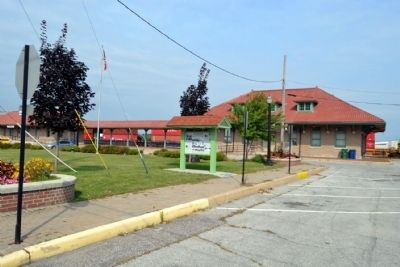
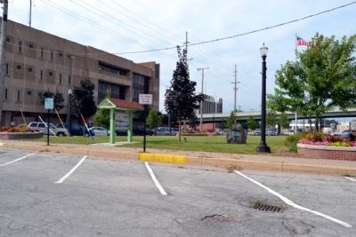
Location. 41° 36.766′ N, 86° 43.382′ W. Marker is in La Porte, Indiana, in LaPorte County. Marker can be reached from the intersection of Michigan Avenue and Washington Street, on the left when traveling north. Marker is located on the lawn south of the Greater La Porte Chamber of Commerce in the historic train depot. Touch for map. Marker is at or near this postal address: 803 Washington St, La Porte IN 46350, United States of America. Touch for directions.
Other nearby markers. At least 8 other markers are within walking distance of this marker. The Lincoln Highway in La Porte County (here, next to this marker); First Log Cabin in LaPorte (a few steps from this marker); World War Memorial Tree LaPorte County (Indiana) (about 500 feet away, measured in a direct line); American Revolutionary Bicentennial (about 600 feet away); LaPorte County Courthouse (about 700 feet away); Historic Etropal Theatre (about 800 feet away); Long Live La Porte (approx. 0.2 miles away); Meinrad Rumely (approx. 0.2 miles away). Touch for a list and map of all markers in La Porte.
Also see . . .
1. The Lincoln Highway Association. Official website of the Lincoln Highway Association. (Submitted on September 17, 2014.)
2. Indiana Lincoln Highway Byway. Official website of the Indiana Lincoln Highway Association. (Submitted on September 17, 2014.)
Credits. This page was last revised on June 16, 2016. It was originally submitted on September 17, 2014, by Duane Hall of Abilene, Texas. This page has been viewed 1,246 times since then and 81 times this year. It was the Marker of the Week July 10, 2016. Photos: 1, 2, 3, 4, 5, 6, 7, 8, 9, 10. submitted on September 17, 2014, by Duane Hall of Abilene, Texas.
