Broken Bow in Custer County, Nebraska — The American Midwest (Upper Plains)
Broken Bow
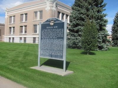
This area was the center of what eventually came to be known as the Sod House Frontier. As homesteaders began to enter this largely treeless region, they made their first homes of prairie sod, which they cut into strips. Early churches, schools and some business places were also made of sod. Homesteaders used sod to construct corrals, henhouses, corn cribs, wind breaks, and even pig pens. One enterprising Custer County resident even constructed a full two storied sod house while others were usually a single story or story and a half.
As the region became more settled, Broken Bow grew, and in 1882 became the county seat of Custer County. That same year, Mr. Jess Gandy donated the sites for the county courthouse and for the city square.
Erected by Gen. Geo. A. Custer Chapter, Daughters of the American Revolution; Historical Land Mark Council. (Marker Number 45.)
Topics and series. This historical marker is listed in this topic list: Settlements & Settlers. In addition, it is included in the Daughters of the American Revolution, and the Nebraska State Historical Society series lists. A significant historical year for this entry is 1882.
Location. 41° 24.116′ N, 99° 38.52′ W. Marker is in Broken Bow, Nebraska, in Custer County. Marker is at the intersection of South E St. (State Highway 2) and 10th Street, on the left when traveling east on South E St.. The marker is on the southeast corner of the courthouse lawn. The Custer County Courthouse faces east. Touch for map. Marker is in this post office area: Broken Bow NE 68822, United States of America. Touch for directions.
Other nearby markers. At least 3 other markers are within 5 miles of this marker, measured as the crow flies. Site of First Custer County Courthouse (within shouting distance of this marker); Broken Bow Town Square (about 600 feet away, measured in a direct line); The Nebraska State Grange (approx. 4˝ miles away).
Credits. This page was last revised on June 16, 2016. It was originally submitted on October 9, 2014, by Joan Shurtliff of Seward, Nebraska. This page has been viewed 647 times since then and 21 times this year. Photo 1. submitted on October 9, 2014, by Joan Shurtliff of Seward, Nebraska. • Andrew Ruppenstein was the editor who published this page.
