Halifax in Halifax Region, Nova Scotia — The Atlantic Provinces (North America)
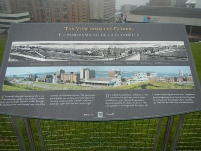
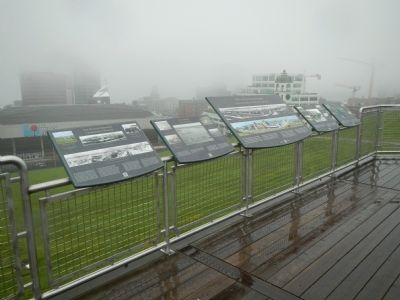
The View from the Citadel / Le panorama vu de la citadelle
The Halifax Explosion / L’explosion d’Halifax
— The Convoys / Les Convois —
Photographed By Barry Swackhamer, June 14, 2014
1. The Halifax Explosion / L’explosion d’Halifax Marker
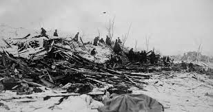
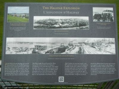
Captions (English / French): (clockwise from the top left) The approximate site of the explosion, as visible from your location, to your left. / Le lieu approximatif de l’explosion, vu du lieu où vous vous trouvez actuellement (à votre gauche).; A general view of the devastated area. / Vue d’ensemble de la zone dévastée.; Canadian troops search for survivors in the wreckage. / Des militaires canadiens recherchent des survivants dans les décombres.; Looking south along the harbour a few days after the explosion. / Le front de mer, vu depuis le nord, quelques jours après l’explosion.
English
From where you are standing, you can see Ground Zero for the Halifax Explosion, the largest man-made explosion prior to the first atomic bomb. On December 6, 1917, as the First World War raged around the globe, the Norwegian relief ship Imo and the French munitions ship Mont Blanc collided far to your left, near the most distant bridge. Mont Blanc caught fire and burned for about twenty-five minutes before the 2925 tons of explosives in her hold detonated. The massive shockwave flattened two square kilometres of the city. More than 1600 people were killed, 9000 wounded and over 6000 left homeless. More Nova Scotians lost their lives in the explosion than on the battlefields of the Western Front.
French
De l’endroit où vous vous trouvez, vous pouvez voir le point zéro de l’explosion d’Halifax, la plus forte explosion d’origine humaine avant celle de la première bombe atomique. Le 6 décembre 1917, alors que la Première Guerre mondiale fait rage, le navire ravitailleur norvégien Imo et le navire français Mont Blanc, chargé de munitions, entrent en collision dans le secteur qui se trouve à votre gauche, près du pont le plus éloigné. Le Mont Blanc prend feu et brûle pendant environ trente-cinq minutes avant que les 2 924 tonnes d’explosifs qui se trouvent dans cales explosent. L’explosion a tue plus de néo-écossais (1 600 mort et 9 000 blesses) que les batailles sur le front ouest.
English
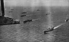
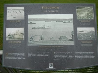
During the First and Second World Wars, thousands of merchant ships and their naval escorts assembled in the harbour below you before proceeding across the Atlantic to Britain. Braving a swarm of German U-boats, many did not make it. A few were sunk just outside the harbour mouth, to your right. The majority, however, survived to reach England, stretching a lifeline to victory.
French
Pendant les deux guerres mondiales, des milliers de navires marchands et leurs escorteurs se rassemblaient dans le port, en contrebas, avant d’entreprendre la traversée de l’Atlantique vers l’Angleterre. Confrontés à l’armada des U boats allemands, bon nombre d’entre eux n’arrivèrent jamais à destination, certains sombrant juste à l’embouchure du pout, à votre droite. Le plupart d’entre eux arrivaient toutefois en Angleterre, constituant un véritable cordon de survie qui allait paver la voie
Photographed By Barry Swackhamer, June 14, 2014
2. The Convoys / Les Convois Marker
Captions (English / French): (clockwise from the top left) Merchant ships assemble in Bedford Basin, far to your left, in 1942. / Navires marchands rassemblés dans le basin de Bedford (à votre gauche(, en 1942; An aerial view of the Citadel, harbour, and Georges Island in 1942. / Vue adrienne de ll citadelle, du port et de lîle Georges, en 1942.; A convoy steams past Georges Island, to your right, on its way to sea. / Un convoi passe devant lîle Georges (à votre droite), en route vers le large.; Canadian destroyer HMCS Restigouche escorts a convoy as it heads out to sea. / Le destroyer canadien HMCS Restigouche escorte un convoi qui part vers le large.; A Canadian merchant vessel arrives in Halifax after suffering torpedo damage. / Un navire marchand canadien rentre au port d’Halifax après avoir été endommagé par une torpille.
English
Thousands of people have stood where you are standing, soldiers and civilians, to take in the view from the Halifax Citadel. Though the city has grown and changed over time, it has retained its basic sense of place. The panoramic photographs you see here were both taken from the same location that lies behind you and to your right.
French
Des milliers de personnes, militaires et civils, son venus à la place que vous occupez actuellement, pour observer le panorama depuis la citadelle d’Halifax. Même si la ville s’est agrandie et a changé au fil de temps, elle a conservé sa configuration de base. Les photos panoramique que vous voyez ici ont été prises du même point de remparts de la citadelle qui se trouve derriere vous, vers votre droite.
(Click on the image to enlarge it and compare points of interest between the two panorama photographs.)
English
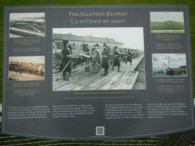
The place where you are standing is known as the Saluting Battery. Here the custom of saluting naval ships with cannon fire was carried out by British forces in the 19th century. For much of the 20th century, the famous Noon Gun was also fired from here, as well
as other salutes for ceremonial purposes. The Canadian Army still fires salutes from this location to mark special occasions, such as Canada Day, keeping an age old tradition alive.
French
Le lieu où vous vous trouvez actuellement est appelé la batterie de salut. Les forces britanniques avaient coutume de saleur les navires par des coups de canon au 19ᵉ siècle. C’est également d’ici qu’on tirait, pendant la majeure partie du 20ᵉ siècle, le célèbre coup de canon de midi, ainsi que d’autres saluts au canon lors de cérémonies. L’armée canadienne tire toujours, de cet endroit. des saluts au canon pour marquer des occasions spéciales comme la Fête du Canada, perpétuant ainsi une tradition séculaire.
English
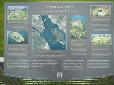
The Halifax Citadel was once the headquarters of a massive array of coastal defences that made Halifax one of the most heavily defended ports in North America. Five of those fortifications are now national historic sites, and together are known as the Halifax Defence Complex. Two of those sites are located on the islands which you can see to your right. As you gaze at the harbour, imagine how crossfire from those islands and surrounding headlands could have repelled any enemy fleet.
French
La citadelle d’Halifax était, a une époque
Photographed By Barry Swackhamer, June 14, 2014
4. The Saluting Battery / La batterie de salut Marker
Captions (English / French): (clockwise from the top left) Eleven 12 pounder guns were mounted in the Saluting Battery from about 1879 to about 1890. / Onze canons de 12 livres faisaient partie de la batterie de salut entre 1870 et 1890.; Delighted children watch a salute being fired from the Citadel in this color postcard image from 1907. / Carte postale de couleur datant de 1907 montrant des enfants qui assisted, ravis, au tir d’un salut au canon depuis la citadelle.; 1st Field Regiment, Royal Canadian Artillery, fires a salute on Remembrance Day, 2009. / Le 1er Régiment d’artillerie de campagne de l’Artillerie royale canadienne tire un salut au canon pour souligner le jour du Souvenir, en 2009.; Members of the Royal Artillery prepare to fire a salut on a winter day in 1900. / Des membres de l’Artillerie royale se préparent à tirer un salut au canon, par un journée d’hiver de 1900.; Royal Artillery, members of the Citadel’s garrison, fire a salut in the late 1890s. / L’Artillerie royale de la garnison de la citadelle tire un salut au canon, vers la fin des années 1890.
Erected by Parks Canada.
Topics. This historical marker is listed in these topic lists: Disasters • Forts and Castles • War, World I • War, World II. A significant historical date for this entry is December 6, 1917.
Location. 44° 38.869′ N, 63° 34.773′ W. Marker is in Halifax, Nova Scotia, in Halifax Region. Marker can be reached from Sackville Street close to Brunswick Street. Touch for map. Marker is at or near this postal address: 5425 Sackville Street, Halifax NS B3J, Canada. Touch for directions.
Other nearby markers. At least 8 other markers are within walking distance of this marker. Halifax Citadel / La Citadelle d’Halifax (within shouting distance of this marker); D-Day/Jour J (within shouting distance of this marker); Women and the Second World War/Les femmes et la Seconde Guerre mondiale (within shouting distance of this marker); "Old" Dalhousie and the Grand Parade
Photographed By Barry Swackhamer, June 14, 2014
5. Fortress Halifax / La forteresse Halifax Marker
Captions (English / French): (center photograph then clockwise from the top left) Aerial view of the Halifax Defence Complex, showing the locations of the five elements that are now national historic sites. / Vue aérienne du Complexe de défense d’Halifax montrant l’emplacement des cinq éléments de defense qui sont aujourd’hui des lieux historiques nationaux.; 1) The Halifax Citadel is a powerful Victorian era fort an the headquarters for the defence complex. / Le citadelle d’Halifax, puissante fortress de l’époque victorienne, était le quartier général du complexe de défense.; 3) Prince Edward, Duke of Kent, ordered this unique circular tower, now known as the Prince of Wales Martello Tower, built in the 1790s as the central work in a series of gun batteries on Point Pleasant. / C’est le prince Edward, duc de Kent, qui a commandé cette tour circulaire unique. Aujourd’hui connue sous le nom de tour Martello Prince de Galles, elle a été construite dans les années 1790 en tant qu’ouvrage central d’une série de batteries de canons située sur la point Pleasant.; 4) A popular destination for hikers, Fort McNab realized its true importance as the guardian of the outer harbour during the First and Second World Wars. / C’est lors des deux guerres mondiales qu’on a mesuré toute l’importance du fort McNab - aujourd’hui destination très prisée des randonneurs - en tant que gardien de l’entrée du port d’Halifax.; 5) The sprawling fortifications of York Redoubt feature majestic views, a network of walking trails, and examples of defensive works from the 1790s to the Second World War. / Les fortifications tentaculaires de la Redoute York offrent des vues magnifiques et comprennent un réseau de sentiers pédestres et des éléments représentatifs des ouvrages défense depuis les années 1790 jusqu’à la Seconde Guerre mondiale.; 2) Georges Island features a network of subterranean tunnels and examples of the most advanced military technology ot the Victorian era, including a system for deploying submarine mines (sea mines). / L’île Georges abrite un réseau de tunnels souterrains et des éléments représentatifs de la technologie militaire la plus avancée de l’époque victorienne, notamment un système de déploiement des mines sou marines.
More about this marker. The marker stands on north wall of the Citadel overlooking Halifax Harbor.
Also see . . .
1. Dec 6, 1917: The Great Halifax Explosion - History Channel. At 9:05 a.m., in the harbor of Halifax in the Canadian province of Nova Scotia, the most devastating manmade explosion in the pre-atomic age occurs when the Mont Blanc, a French munitions ship, explodes 20 minutes after colliding with another vessel. (Submitted on October 24, 2014, by Barry Swackhamer of Brentwood, California.)
2. May 24, 1917: British naval convoy system introduced - History Channel. On this day in 1917, driven by the spectacular success of the German U-boat submarines and their attacks on Allied and neutral ships at sea, the British Royal Navy introduces a newly created convoy
system, whereby all merchant ships crossing the Atlantic Ocean would travel in groups under the protection of the British navy. (Submitted on October 24, 2014, by Barry Swackhamer of Brentwood, California.)
Credits. This page was last revised on August 16, 2017. It was originally submitted on October 24, 2014, by Barry Swackhamer of Brentwood, California. This page has been viewed 457 times since then and 10 times this year. Photos: 1, 2, 3, 4, 5, 6, 7, 8. submitted on October 24, 2014, by Barry Swackhamer of Brentwood, California. • Andrew Ruppenstein was the editor who published this page.
