Lunenburg in Lunenburg County, Nova Scotia — The Atlantic Provinces (North America)
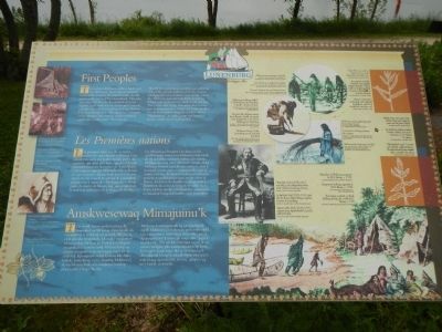
First Peoples
Les Premières nations
— Amskwesewaq Mimajuinu’k —

Photographed By Barry Swackhamer, June 16, 2014
1. First Peoples Marker
Captions (Englsih / French): (left side, top to bottom) Mi’kmaq petroglyphes, c. 1600s, Kejimkujik National Park, / Petroglyphes mi’kmaq, v. 1600, parc national Kejimkujik.; Portraite of a Mi’kimaq woman, c. 1859. / Portrait d’une femme mi’kmaq, v. 1859; (right side, clockwise from the top left) Mi’kmaq men preparing to catch fish. / Des Mi’kmaq se préparent à pêcher.; Sweet Fern was used to treat poison ivy rash, rheumatism and skin sores. / La comptonie à feuilles d’asplénie (aussi appelée fougère odorante) servait à traiter les éruptions d’herbe à la puce, le rhumatisme et les lésions cutanées.; Mi’kmaq woman gathering seeds. / Une femme mi’kmaq ramasse des roseaux.; Mullein leaves were used to treat asthma. They were steeped in water and the fumes inhaled. / Les feuilles de molène servaient à traiter l’asthme. sous forme d’infusion, on en respirait les vapeurs.; Watercolour of Mi’kmaq encampment by H.N. Binney, c. 1790. / Campement mi’kmaq, aquarelle de H.N. Binney, V. 1790.; Chief John Noel (1829-1911) was chief of the Sikepne’ktik district which includes Lunenburg County. / Le chef John Noel (1829-1911) était chef du district Sikepne’ktik que englobait le comté de Lunenburg.; Mi'kmaq girl collecting shellfish. A Mi’kmaq name for Lunenburg is Aseedik - the place of clams. / Une jeun fille mi’kmaq ramasse des mollusques. Asseedik, qui signifie «lieu des palaurdes» est un nom Mi’kmaq pour Lunenburg.
The earliest inhabitants of these lands were the Mi’kmaq. Their nation included most of the territory that later became Acadia and possibly parts of Newfoundland. This area was called Mi’kma’ki. It consisted of seven regions, each with its own Chief and Council, with the Grand Chief residing in Cape Breton. The Lunenburg area, “Merligueche”, was part of the Sikepne’ktik district, which included south and southwestern Nova Scotia.
The Mi’kmaq practiced a hunting and gathering way of life, greatly influenced by the seasons. Merligueche was a summer community, where the Mi’kmaq harvested shellfish, including lobster, and ocean species, such as cod and bass. They were able to dry fish and gather berries here in preparation for winter. In winter, families would head inland along the LaHave River “Pijelooaskak” to make camp and hunt for moose, caribou and small game.
French
Les premiers habitants de ces terres étaient les autochtones mi’kmaq. Leur nation s’étendait sur la plus grande partie du territoire qui allait plus tard s’appeler l’Acadie et possiblement sur des parties de Terre-Neuve. Cette région s’appelait Mi’kma’ki. Elle se divisait en sept secteurs, chacun étant pourvu de son chef et de son conseil. Le secteur de Lunenburg connu sous le nom de «Merligueche», faisait partie du district de Sikepme’ktik, qui comprenait le sud et le sud-ouest de la Nouvelle-Écosse.
Les Mi’kmaq se livraient à la chasse et à la cueillette pour assurer leur subsistance; leur mode de vie suivait beaucoup le rythme des saisons. Merligueche était un collectivité estivale où les Mi’kmaq faisaient la pêche au crustacés, dont le homard, et aux espèces marines telles que la morue et le bar. Ils faisaient également sécher le poisson et cueillaient des baies en prévision de l’hiver. En hiver, les familles se dirigeaient à l’intérieur des terres le long de la vallée de la rivière LaHève où elles installaient leur campement et chassaient l’orignal, le caribou et le petite gibier.
Mikmawiskmk
Ta’n wenik mawi amskwesewaq ula maqikek ne Mi’kmaq. Eimu’tipnik ula maqmikew ta’n kiskuk ter-nenasik Ake’tia aq etuk pkesikn Ktaqmkuk. Ula uijey maqmikew tel-nenasikip Mi’kma’ki. L’uiknek te’sikipnn maqnukal ta’n mawa’tmk Mi’kma’kitip aq e’tasiw maqmikew pema’toqop saqaw aq elukowji. Kji-saqmaw wikip Unama’kik. Nike’kiskuk, Lunenburg, ta’n i’-tluisikip Makikewe’j tle’tip Sikepne’ktik ta’n wiaqtaqne’wasikip pkite’snuke’l Nopa Sko’sia.
Mi’kmaq ketantaqatipnik aq mewisultipnil nipkl. Malikewe’ji-wskowita’pnik pasik nipkl ta’n ktantu’titew nine’juey staqe nike’jakejk, aq apaqtukewe’k mine’jk staqe nike’ peju’k aq ji’ka’wk. Tett etl-luk wala’tipni mine’jk aq mawte’mi’tipnn pkwimann ilajuktmi’tip kesik. Ta’n tujiw kesik kitu’ ika’q, mimajuinu’k eliwsultipnik kisoqe’k teluisik Pijelu’aska’q ta’n wiki’titaqq aq ktana’tita tia’mu, qalipu’a aq me’j ktikik waisisji’jk.
Erected by Town of Lunenburg.
Topics. This historical marker is listed in this topic list: Native Americans.
Location. 44° 22.593′ N, 64° 18.888′ W. Marker is in Lunenburg, Nova Scotia, in Lunenburg County. Marker can be reached from Linden Avenue close to Bluenose Drive. Touch for map. Marker is in this post office area: Lunenburg NS B0J, Canada. Touch for directions.
Other nearby markers. At least 8 other markers are within walking distance of this marker. Foreign Protestant Settlement in Lunenburg (within shouting distance of this marker); The Early Acadian History of Lunenburg (within shouting distance of this marker); Merligueche (within shouting distance of this marker); Lunenburg’s Fishing Industry to the 1870’s (about 180 meters away, measured in a direct line); Old Town Lunenburg Historic District (approx. 0.3 kilometers away); St. John's Anglican Church / L'église anglicane St. John's (approx. 0.3 kilometers away); St. John's Parish Hall (approx. 0.3 kilometers away); Lunenburg’s Fishing Industry 1870’s - 1940’s (approx. 0.3 kilometers away). Touch for a list and map of all markers in Lunenburg.
Click on the ad for more information.
Please report objectionable advertising to the Editor.
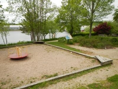
sectionhead>More about this marker. This marker is locate on path in front of the Old French Cemetery, near the water's edge.Please report objectionable advertising to the Editor.
Also see . . . Mi'kmaq - Wikipedia. The Mi'kmaq are a First Nations people, indigenous to Canada's Maritime Provinces and the Gaspé Peninsula of Quebec. They call this region Mi'kma'ki. Others today live in Newfoundland and the northeastern region of Maine. The nation has a population of about 40,000 (plus about 25,000 in the Qalipu First Nation in Labrado, of whom nearly 11,000 speak the Mi'kmaq language. Once written in Mi'kmaq hieroglyphic writing, it is now written using most(Iy) letters of the standard Latin alphabet. (Submitted on October 25, 2014, by Barry Swackhamer of Brentwood, California.)
Credits. This page was last revised on June 16, 2016. It was originally submitted on October 25, 2014, by Barry Swackhamer of Brentwood, California. This page has been viewed 564 times since then and 19 times this year. Photos: 1, 2. submitted on October 25, 2014, by Barry Swackhamer of Brentwood, California. • Andrew Ruppenstein was the editor who published this page.
