North Shore in Pittsburgh in Allegheny County, Pennsylvania — The American Northeast (Mid-Atlantic)
The Pittsburgh Point
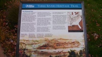
Three Rivers Heritage Trail
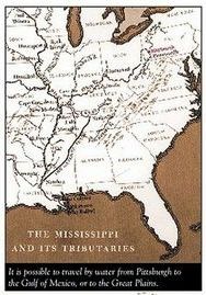
Few cities have the visual drama of Pittsburgh, or so rich a collection of national memories. At the Pittsburgh Point two rivers converge: The Allegheny River flowing from the north and the Monongahela River from the south. These rivers drain the Allegheny Mountains, and unite to form the mighty Ohio River which flows west to the Mississippi.
Geography is Destiny. The history of this city was determined by its rivers. Native Americans named these waterways long ago. French and British armies fought to dominate them in the 18th century. Fort Pitt was built in 1758 as a control point for the British Empire in America. After the Revolution, pioneers saw Pittsburgh as the Gateway to the West. In the mid-19th century, slaves saw Pittsburgh as the Crossroads to Freedom, and escaped north via river routes from the south.
During the 19th century thousands of steamboats built along these shores carried immigrants and cargoes to the West. The rivers became busy commercial routes. Great fortunes were made in Pittsburgh's "Golden Triangle" as the city benefited from the inland water highways.
Located in a region rich in fuel and mineral resources, Pittsburgh became a vital center of industry, commerce and transportation. Railways eventually paralleled the rivers, further linking the city to all parts of the expanding nation.
After World War II, Pittsburgh rebuilt itself in a famous urban "Renaissance" and became the first major American city in the 20th century to undertake a complete renewal of its downtown core. Today Pittsburgh is a center of banking, medicine and education. When the era of "Big Steel" ended in the 1970s, the diversity of Pittsburgh industry was a key to the future.
The Pittsburgh Point has always been a symbol. It represents the promises of American history, and new directions for the future city.
Erected by The Buhl Foundation, City of Pittsburgh, Friends of the Riverfront, Bally Design.
Topics. This historical marker is listed in these topic lists: Industry & Commerce • Native Americans • Waterways & Vessels. A significant historical year for this entry is 1758.
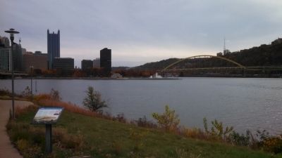
Location. 40° 26.689′ N, 80° 0.932′ W. Marker is in Pittsburgh, Pennsylvania, in Allegheny County. It is in North Shore. Marker can be reached from North Shore Trail. Located between The Carnegie Science Center and Heinz Field on Pittsburgh's North Shore Trail. Part of the Three Rivers Heritage Trail. Touch for map. Marker is in this post office area: Pittsburgh PA 15212, United States of America. Touch for directions.
Other nearby markers. At least 8 other markers are within walking distance of this marker. Langley Observatory Clock (about 400 feet away, measured in a direct line); Three Rivers Stadium (about
500 feet away); County of Allegheny Law Enforcement Officers Memorial (about 500 feet away); First Professional Football Game (about 600 feet away); Three Rivers Heritage Trail (about 700 feet away); The Immaculate Reception (approx. 0.2 miles away); Southwestern Pennsylvania World War II Memorial (approx. 0.2 miles away); Vietnam Veterans Monument (approx. ¼ mile away). Touch for a list and map of all markers in Pittsburgh.
Also see . . . Three Rivers Heritage Trail. Friends of the Riverfront (Submitted on October 29, 2014, by Mike Wintermantel of Pittsburgh, Pennsylvania.)

Photographed By Mike Wintermantel
3. The Pittsburgh Point Marker
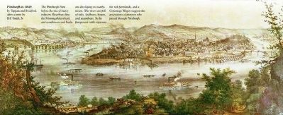
Lower Painting
Pittsburgh in 1849
by Tappan and Bradford, after a print by B.F. Smith, Jr.
The Pittsburgh Point before the rise of heavy industry. Riverboats line the Monongahela wharf, and warehouses and banks are developing on nearby streets. The rivers are full of rafts, keelboats, barges, and steamboats. In the foreground cattle represent the rich farmlands, and a Conestoga Wagon suggests the generations of pioneers who passed through Pittsburgh.
Credits. This page was last revised on February 2, 2023. It was originally submitted on October 29, 2014, by Mike Wintermantel of Pittsburgh, Pennsylvania. This page has been viewed 611 times since then and 30 times this year. Photos: 1, 2, 3, 4. submitted on October 29, 2014, by Mike Wintermantel of Pittsburgh, Pennsylvania.


