Pineville in Rapides Parish, Louisiana — The American South (West South Central)
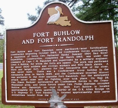
Fort Buhlow and Fort Randolph
Inscription.
Fort Buhlow and Fort Randolph were earthwork/moat fortifications constructed beginning October 1864 by Confederate forces anticipating a repetition of Union Gen. Nathaniel Banks’ Summer 1864 Red River
Expedition. Construction, completed March 1865, was under the command of Capt. C.M. Randolph and supervised by a military engineer, Lieut. A. Buhlow, for whom the forts are named. The work was performed
by about 1500 soldiers and civilian workers and 500 black slaves. A third and larger fort, planned for the Alexandria side of the river, was never built. There was a Confederate troop buildup in the
Alexandria area in March 1865, and the Confederate ironclad Missouri was anchored in the river opposite Fort Randolph, but the anticipated attack never came and no fighting ever took place. On May 26,
Gen. Simon Buckner surrendered all Confederate forces in the Trans-Mississippi, and Union forces under Gen. Philip Sheridan occupied Buhlow and Randolph on June 2, 1865. Fort Buhlow is located approximately 60 yards upstream (north) of the O.K. Allen Bridge on
US Highway 71. Fort Randolph is located approximately 600 yards downstream (south) of the bridge.
Erected by T. O. Moore Chapter of the United Daughters of the Confederacy.
Topics and series. This historical marker is listed in these topic lists: Forts and Castles • War, US Civil. In addition, it is included in the United Daughters of the Confederacy series list. A significant historical year for this entry is 1864.
Location. Marker has been reported missing. It was located near 31° 19.633′ N, 92° 26.893′ W. Marker was in Pineville, Louisiana, in Rapides Parish. Marker was on Monroe Highway (U.S. 71/165) near Rainbow Drive, on the left when traveling east. Traveling on US71/US165 across the O.K. Allen bridge from Alexandria to Pineville. The marker is on the left, a few dozen yards from the bridge. Touch for map. Marker was in this post office area: Pineville LA 71360, United States of America. Touch for directions.
Other nearby markers. At least 8 other markers are within walking distance of this location. Welcome to Fort Buhlow (within shouting distance of this marker); How Fort Buhlow was built (about 300 feet away, measured in a direct line); Why Was Fort Buhlow Built? (about 300 feet away); Deserting soldiers and the end of the war (about 300 feet away); Who was Fort Buhlow named after? (about 300 feet away); Who was stationed at Fort Buhlow? (about 400 feet away); Desertion and the end of the War (approx. 0.2 miles away); How was Fort Randolph Built? (approx. 0.2 miles away). Touch for a list and map of all markers in Pineville.
More about this marker. Both sides of the marker are inscribed with the same message and both sides have illegible portions at the base. Internet research identified the erecting organization as the Thomas Overton Moore Chapter (No. 640) of the United Daughters of the Confederacy.
Marker missing in early 2020, probably due to expansion of Highway 71 and bridge.
Regarding Fort Buhlow and Fort Randolph. This marker incorrectly states that Union General Nathaniel P. Banks' Red River Campaign took place in the Summer of 1864. In fact the Red River Campaign was in the Spring of 1864.
Credits. This page was last revised on March 22, 2020. It was originally submitted on May 21, 2008, by Texmexfla of Houston, Texas. This page has been viewed 4,416 times since then and 15 times this year. Photo 1. submitted on May 21, 2008, by Texmexfla of Houston, Texas. • Craig Swain was the editor who published this page.
Editor’s want-list for this marker. A wide view photo of the marker and the surrounding area in context. • Can you help?
