Annapolis Royal in Annapolis County, Nova Scotia — The Atlantic Provinces (North America)
Charles Fort / Le fort Charles
Charles de Menou d’Aulnay
— (ca. 1604-1650) / (v.1604-1650) —
English
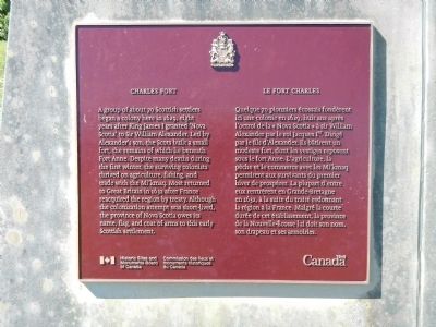
A group of about 70 Scottish settlers began a colony here in 1629, eight years after King James I granted ‘Nova Scotia’ to Sir William Alexander. Led by Alexander’s son, the Scots built a small fort, the remains of which lie beneath Fort Anne. Despite many deaths during the first winter, the surviving colonists thrived on agriculture, fishing, and trade with the Mi’kmaq. Most returned to Great Britain in 1632 after France reacquired the region by treaty. Although the colonization attempt was short-lived, the province of Nova Scotia owes it name, flag, and coat of arms to this early Scottish settlement.
French
Quelque 70 pionniers écossais fondèrent ici une colonie en 1629, huit ans après l’octroi de la «Nova Scotia» à sir William Alexander par le roi Jacques Ier. Dirigé par le fils d’Alexandre, ils bâtirent un modeste fort, dont les vestiges reposent sous le fort Anne, L’agriculture, le pêche et le commerce avec les Mi’kmaq permirent aux survivants du premier hiver de prospérer. La plupart d’entre eux rentrèrent en Grande-Bretagne in 1632, à la suite du traité redonnant la région à la France. Malgré la courte durée de cet établissement, la province de Nouvelle-Écosse lui doit son nom, don drapeau et ses armoiries.
(ca. 1604-1650) / (v.1604-1650)
English
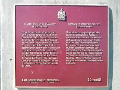
This eminent sea captain played a key role in the settlement of Acadia. He commanded La Hève and Port Royal in 1636, and became governor of Acadia in 1647. Over a fourteen-year period, he oversaw the construction of forts, mills, and schools and ventured into shipbuilding. He drained marshes with a system of dykes and tide gates, enabling settlers to survive through agriculture. Charles de Menou d’Aulnay was one of the great architects of French settlement in Canada.
French
Cet éminent capitaine de navire joua un rôle majeur dans la colonisation de l’Acadie. En 1636, il détient le commandement de La Hève et de Port-Royal et devient, en 1647, gouverneur de l’Acadie. En quatorze ans, il fait ériger des forts, des moulins et des écoles et se lance dans la construction navale. En outre, il fait assécher des marais au moyen de digues et d’aboiteaux, permettant aux colons de vivre de l’agriculture et de l’élevage. Charles de Menou d’Aulnay fut l’un de grands artisans de peuplement français du Canada.
Erected by Historic Sites & Monuments Board of Canada.
Topics and series. This historical marker is listed in these topic lists: Forts and Castles • Settlements & Settlers. In addition, it is included in the Acadian History, and the Canada, Historic Sites and Monuments Board series lists. A significant historical year for this entry is 1629.
Location. 44° 44.449′ N, 65° 31.215′ W. Marker is in Annapolis Royal, Nova Scotia, in Annapolis County. Marker can be reached from St. George Street close to St. Anthony Street, on the left when traveling west. Touch for map. Marker is at or near this postal address: 323 St George Street, Annapolis Royal NS B0S, Canada. Touch for directions.
Other nearby markers. At least 8 other markers are within walking distance of this marker. Early Use of Site (a few steps from this marker); Acadian Dykeland (within shouting distance of this marker); Jean Paul Mascarene (within shouting distance of this marker); Samuel Vetch (within shouting distance of this marker); The Flag Bastion (about 90 meters away, measured in a direct line); The Black Hole / Le cachot (about 120 meters away); Fort Anne, a Bastioned Fort (about 120 meters away); Port-Royal (about 150 meters away). Touch for a list and map of all markers in Annapolis Royal.
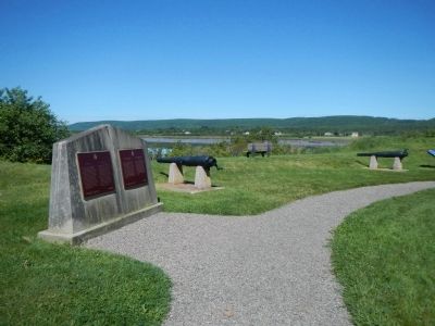
More about this marker. This marker is located on the grounds of Fort Anne National Historic Site.
Also see . . . Charles de Menou d’Aulnay - Dictionary of Canadian Biography. While his rivals were almost entirely concerned with trade, d’Aulnay’s ambition was to establish a lasting colony, and he realized that this could be done only by settling families in the country and by giving them the means of subsisting on the spot and by themselves, through the cultivation of the land, through fishing, and through industry. The colony that he left in Acadia was well rooted and vigorous enough to resist the English occupation and the 20 years of neglect that followed. (Submitted on November 2, 2014, by Barry Swackhamer of Brentwood, California.)
Credits. This page was last revised on June 16, 2016. It was originally submitted on November 2, 2014, by Barry Swackhamer of Brentwood, California. This page has been viewed 461 times since then and 12 times this year. Photos: 1, 2, 3. submitted on November 2, 2014, by Barry Swackhamer of Brentwood, California. • Andrew Ruppenstein was the editor who published this page.


