Annapolis Royal in Annapolis County, Nova Scotia — The Atlantic Provinces (North America)
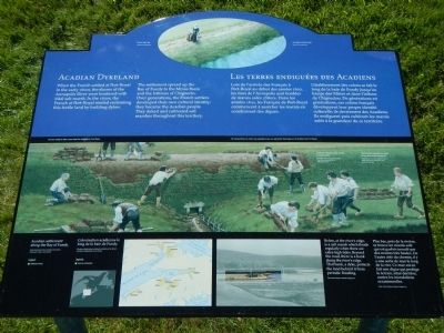
Acadian Dykeland
Les terres endiguées des Acadiens

Photographed By Barry Swackhamer, June 17, 2014
1. Acadian Dykeland Marker
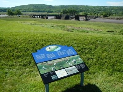
Captions (English / French): (top) Dyke at high tide. Une digue à marée haute.; Visit our exhibit to learn more about the Acadians at Port-Royal. / Ne manquez pas de visiter nos expositions pour en apprendre divagate sur les Acadiens de Port-Royal.; (bottom row) Acadian settlement along the Bay of Fundy. / Colonisation acadienne de long de la baie de Fundy.; Below, at the river’s edge, is a salt marsh which floods regularly when there are extra-high tides. Beyond the road, there is a bank along the river’s edge. That bank, a dyke, protects the land behind it from periodic flooding. / Plus bas, près de la rivière, se trouvé un marais salé qui est parfois inondé par des marées très hautes. De l’autre côté du chemin, il y a une sort de mur le long de la rive. Ce mur est en fait une digue qui protège le terrain, situé derriere contre les inondations occasionnelles.
When the French settled at Port-Royal in the early 1600s, the shores of the Annapolis River were bordered with tidal salt marsh. In the 1630s, the French at Port-Royal started reclaiming this fertile land by building dykes.
The settlement spread up the Bay of Fundy to the Minas Basin and the Isthmus of Chignecto. Over generations, the French settlers developed their own cultural identity; they became the Acadian people. They dyked and cultivated salt marshes throughout this territory.
French
Lors de l’arrivée des Français à Port-Royal au début des années 1600, les rives de l’Annapolis sont bordées de marais salés côtiers. Dans les années 1630, les Français de Port-Royal commencent à assécher les marais en construisant des digues.
L’établissement des colons se fait le long de la baie de Fundy jusqu’au bassin des Mines et dans l’isthme de Chignectou. De générations en générations, ces colons français développent leur propre identité culturelle; ils deviennent des Acadiens. Ils endiguent puis cultivent les marais salés a la grandeur de ce territoire.
Erected by Parks Canada.
Topics and series. This historical marker is listed in these topic lists: Agriculture • Settlements & Settlers . In addition, it is included in the Acadian History series list. A significant historical year for this entry is 1600.
Location. 44° 44.444′ N, 65° 31.171′ W. Marker is in Annapolis Royal, Nova Scotia, in Annapolis County. Marker can be reached from St. George Street close to St. Anthony Street, on the left when traveling west. Touch for map. Marker is at or near this postal address: 323 St George Street, Annapolis Royal NS B0S, Canada. Touch for directions.
Other nearby markers. At least 8 other markers are within walking distance of this marker. Jean Paul Mascarene (a few steps from this marker); Charles Fort / Le fort Charles (within shouting distance of this marker); Fort Anne, a Bastioned Fort (within shouting distance of this marker); Early Use of Site (within shouting distance of this marker); Samuel Vetch (about 90 meters away, measured in a direct line); The Flag Bastion (about 90 meters away); The Black Hole / Le cachot (about 90 meters away); Captures of Port Royal (about 120 meters away). Touch for a list and map of all markers in Annapolis Royal.
More about this marker. This marker is located on the grounds of Fort Anne National Historic Site.
Also see . . . The Acadians and the Creation of the Dykeland 1680–1755. Landscape of Grand Pré website entry:
The Acadians are a people born in North America. Their identity is the result of the transformation of their individual European values as they came into contact with a new environment and new people. Their story begins with the French settlement of North America. (Submitted on November 2, 2014, by Barry Swackhamer of Brentwood, California.)

4. How the Acadians reclaimed the land.
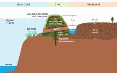
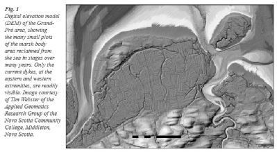
The technology that the Acadians used to transform wetlands and marshes could not have been simpler: special spades, pitchforks, axes, and hollowed-out tree trunks. Much more important than the tools was the ingenuity of the people to read the natural drainage systems of the marshes and then to build dykes that channelled the flow of those creeks in only one direction, discharging into the sea. One element of the Acadians’ success was to use sod cut from the original wetlands in their earthen dykes.
Credits. This page was last revised on January 22, 2024. It was originally submitted on November 2, 2014, by Barry Swackhamer of Brentwood, California. This page has been viewed 578 times since then and 13 times this year. Photos: 1, 2, 3, 4. submitted on November 2, 2014, by Barry Swackhamer of Brentwood, California. • Andrew Ruppenstein was the editor who published this page.

