Marion in Crittenden County, Kentucky — The American South (East South Central)
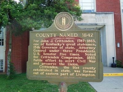
County Named, 1842
For John J. Crittenden, 1787-1863, one of Kentucky’s great statesmen. 15th Governor of the state. Attorney General under three Presidents. US Senator five times. Noted for Crittenden Compromise, 1860, futile effort to avert Civil War and preserve the Union.
Crittenden, the 91st county established in state, was formed out of eastern part of Livingston.
Erected 1968 by Kentucky Historical Society and Kentucky Department of Highways. (Marker Number 1160.)
Topics and series. This historical marker is listed in these topic lists: Government & Politics • Patriots & Patriotism • War, US Civil. In addition, it is included in the Kentucky Historical Society series list. A significant historical year for this entry is 1860.
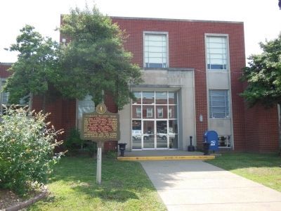
Location. 37° 19.971′ N, 88° 4.907′ W. Marker is in Marion, Kentucky, in Crittenden County. Marker is on Kentucky Route 91, 0.1 miles east of Court Street, on the left when traveling west. Marker is beside sidewalk near north courthouse entrance. Touch for map. Marker is at or near this postal address: 107 South Main Street, Marion KY 42064, United States of America. Touch for directions.
Other nearby markers. At least 8 other markers are within 5 miles of this marker, measured as the crow flies. Courthouse Burned (within shouting distance of this marker); Crittenden County Courthouse, Marion (within shouting distance of this marker); Senator W. J. Deboe / Senators from Marion (about 700 feet away, measured in a direct line); Family of Judges (approx. 0.2 miles away); F. Julius Fohs (1884-1965) / Fohs Hall (approx. 0.2 miles away); Forrest Reconnoitered (approx. 1.2 miles away); Chapel Hill Presbyterian Church / Pioneer Church (approx. 2.8 miles away); A Renowned Senator (approx. 4.2 miles away). Touch for a list and map of all markers in Marion.
Also see . . .
1. Crittenden County Kentucky was established in 1842. Crittenden County, KYGenWeb Project website entry:
The county was named for John Jordan Crittenden (1787-1863)who was U.S. Attorney General, Senator and the 15th Governor of Kentucky (Submitted on November 27, 2014, by Cosmos Mariner of Cape Canaveral, Florida.)
2. History of Crittenden County, Kentucky. Crittenden Press website entry:
The first county court was held at the house of Samuel Ashley on April 4, 1842. The following justices of the peace were in attendance: Joseph Hughes, James Cruce, Robert H. Hughes, Abner Peter Clinton, John D. Gregory, Robert Hill, Henry R.D. Coleman and Samuel L. Phillips. (Under the Constitution, prior to 1850, there were no county judges and the county courts were held by the magistrates.)
Crittenden was once one of the nation's largest producers of fluorspar. (Submitted on November 27, 2014, by Cosmos Mariner of Cape Canaveral, Florida.)
3. John Jordan Crittenden, Jr. Find A Grace website entry:
US Senator, Kentucky Governor, Presidential Cabinet Secretary. The most famous member of the Crittenden political dynasty, he was born near Versailles, Kentucky. (Submitted on November 27, 2014, by Cosmos Mariner of Cape Canaveral, Florida.)
Photographed By Allen C. Browne, August 9, 2015
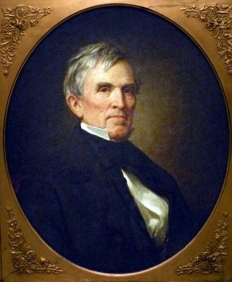
3. John J. Crittenden
This 1857 portrait of John J. Crittenden by George Peter Alexander Healy hangs in the National Portrait Gallery in Washington DC.
“During the campaign of 1860, many southerners declared that Abraham Lincoln's election to the presidency would give them no choice but to secede from the Union. One notable exception was Kentucky senator John Crittenden. This passionate advocate of national unity undertook the task of reaching an accommodation designed to derail the secession movement of 1861. Central to his plan was a proposal that would have permanently guaranteed the rights of slaveholders below the nation's 36°30' parallel. By now, however, bitterness over the slavery question ran too deeply, and neither North nor South could accept this conciliating measure. Instead, Crittenden had to content himself with ensuring that his own Kentucky did not secede; it was largely through his exertions that this state remained loyal to the Union after most of the South had left. ” — National Portrait Gallery
“During the campaign of 1860, many southerners declared that Abraham Lincoln's election to the presidency would give them no choice but to secede from the Union. One notable exception was Kentucky senator John Crittenden. This passionate advocate of national unity undertook the task of reaching an accommodation designed to derail the secession movement of 1861. Central to his plan was a proposal that would have permanently guaranteed the rights of slaveholders below the nation's 36°30' parallel. By now, however, bitterness over the slavery question ran too deeply, and neither North nor South could accept this conciliating measure. Instead, Crittenden had to content himself with ensuring that his own Kentucky did not secede; it was largely through his exertions that this state remained loyal to the Union after most of the South had left. ” — National Portrait Gallery
Photographed By Cosmos Mariner, June 7, 2012
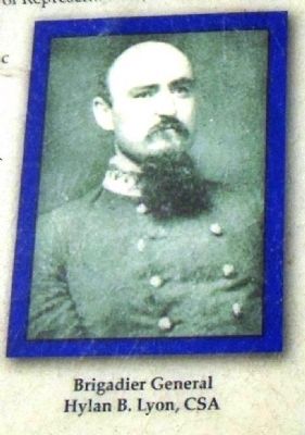
7. Brigadier General Hylan B. Lyon, CSA
According to local tradition, the Crittenden County Courthouse was burned by Brigadier General Hylan B. Lyon, CSA on January 25, 1865 as part of a raid into Kentucky during which Lyon’s troops burned a number of western Kentucky county courthouses.
Credits. This page was last revised on January 3, 2022. It was originally submitted on November 26, 2014, by Cosmos Mariner of Cape Canaveral, Florida. This page has been viewed 517 times since then and 23 times this year. Photos: 1. submitted on November 26, 2014, by Cosmos Mariner of Cape Canaveral, Florida. 2. submitted on November 27, 2014, by Cosmos Mariner of Cape Canaveral, Florida. 3. submitted on September 6, 2015, by Allen C. Browne of Silver Spring, Maryland. 4, 5, 6, 7, 8, 9. submitted on November 27, 2014, by Cosmos Mariner of Cape Canaveral, Florida. • Al Wolf was the editor who published this page.
