Near St Lunaire-Griquet in Great Northern Peninsula, Newfoundland, Newfoundland and Labrador — The Atlantic Provinces (North America)
The End of a Quest: L’aboutissement d’une quête
Fishing for the Past: À la recherche du passé
Inscription.
English:
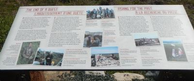
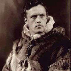
Following clues in the ancient Icelandic sagas, and the writings of Viking scholars and enthusiasts, Norwegian writer and explorer Helge Ingstad arrived at L’Anse aux Meadows in 1960. When he asked whether there were any unusual mounds or low turf wall nearby, community elder and fisherman George Decker led him to the site that local people called “the Old Indian Camp”.
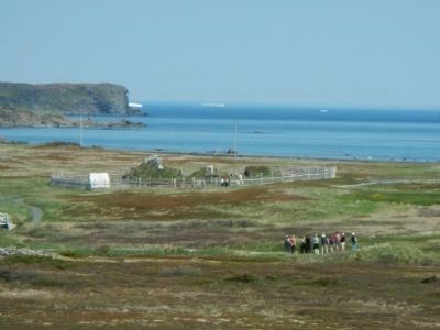
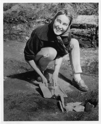
Here the long search for the Norse foothold in North America ended, and the painstaking detective work of Anne Stine Ingstad and other archaeologists began. Through the following decades of archaeological work, area residents played a vital role in uncovering the Viking and Aboriginal history of their home.
L’Anse aux Meadows is the village to the northeast. Its name may be a corruption of l’anse à la Médée, meaning Medea’s Cove. This was part of the French Shore until 1904, and by treaty, vessels from France had the right to fish and establish shore stations all along this coast. Shore stations were often named after the ships that worked there. Many French ships in the 1600s and 1700s were named after Medea, the heroine of a Greek tragic play. The name was altered when English-speaking settlers arrived, although the bay in front of the village is still called Medee Bay.
French:
En se fiant aux indices tirés des antiques sagas islandaises et sur les ouvres des érudits et des passionnés qui s’intéressent aux Vikings, l’écrivain et explorateur norvégien Helge Ingstad est arrivé à L’Anse aux Meadows en 1960. Lorsqu’il a demandé s’il y avait des monticules inhabituels ou de murs bas en gazon dans les environs, l’aîné de la communauté, George Decker, qui était aussi pêcheur, l’a emmené sur le site que la population locale appelait «le vieux camp indien».
La long recherche de la preuve d’une présence scandinave en Amérique du Nord s’est achevée à cet endroit et la laborieux travail d’enquête d’Anne Stine Ingstad et d’autres archéologues a commencé. Au cours des décennies de travail archéologique qui ont suivi, les habitants de la région ont joué un rôle central dans la découverte du passé viking et autochtone de ce lieu.
L’Anse aux Meadows est un village situé au nord-est. Son nom est peut-être un déformation de l’anse à la Médée. En effet, il a fait partie de la côte française jusqu’en 1904, en un traité autorisait les navires venus de France à pêcher et à établir des stations littorales le long de cette côte. Les stations littorales prenaient souvent le nom des navires qui naviguaient à cet endroit. De nombreux navires français du 17ᵉ et du 18ᵉ siècle avaient été nommés d’après Médée, l’heroïne d’une tragédie grecque. Ce nom a été transformé avec l’arrivée des pionniers anglophones, même si la baie située en face du village est toujours appelée baie Medee.
Topics. This historical marker is listed in these topic lists: Anthropology & Archaeology • Exploration • Settlements & Settlers. A significant historical year for this entry is 1960.
Location. 51° 35.489′ N, 55° 31.963′ W. Marker is near St Lunaire-Griquet, Newfoundland and Labrador, in Great Northern Peninsula, Newfoundland. Marker can be reached from unnamed road close to Newfoundland and Labrador Route 43. Touch for map. Marker is in this post office area: St Lunaire-Griquet NL A0K 2X0, Canada. Touch for directions.
Other nearby markers. At least 1 other marker is within walking distance of this marker. L’Anse aux Meadows (within shouting distance of this marker).
More about this marker. L'Anse aux Meadows is at the end of an unnamed road, off of Provincial Road 436; 30 km from the intersection of Highway 430 and Provincial Road 436. The directions to L'Anse aux Meadows are well signed. The marker is on the path between the parking lot and the Visitors Centre.
Also see . . .
1. Where is Vinland? - Canadian Mysteries. This website will take you along Leif’s route to North America and Vinland. Where was this land? Many claim to have found it from northern Labrador all the way down to Virginia. Which is the real Vinland? Leif left only a few tantalizing clues as do medieval Icelandic manuscripts. Solving the mystery of Vinland requires putting these together with archaeological discoveries, a knowledge of what the Vikings were capable of, what their motivations might have been and an understanding of the people and environment of the land they encountered. (Submitted on December 14, 2014, by Barry Swackhamer of Brentwood, California.)
2. Helge Ingstad. Helge Marcus Ingstad was a Norwegian explorer. After mapping some Norse settlements, Ingstad and his wife Anne Stine, an archaeologist, in 1960 found remnants of a Viking settlement in L'Anse aux Meadows in the Province of Newfoundland in Canada. With that they were the first to prove conclusively that the Greenlandic Norsemen had found a way across the Atlantic Ocean to North America... (Submitted on December 14, 2014, by Barry Swackhamer of Brentwood, California.)
3. Anne Stine Ingstad. She studied archaeology at the University of Oslo in the 1950s. In 1960 her husband discovered settlement traces at L'Anse aux Meadows on the island of Newfoundland. Between 1961 and 1968, Anne Stine Ingstad led an excavation of the settlement with an international team of archaeologists from Sweden, Iceland, Canada, U.S. and Norway. The excavation revealed the remains of an early 11th century Norse settlement. (Submitted on December 14, 2014, by Barry Swackhamer of Brentwood, California.)
4. L'Anse aux Meadows. The excavation of L'Anse aux Meadows was conducted on a vulnerable site and followed by extensive laboratory study. It was possible, thanks to a palaeo-ecological study making use of seed and pollen fossils, to reconstruct the long-term landscape and surroundings of this human settlement. In spite of the astonishing appearances of its archaeological vestiges, L'Anse aux Meadows is an outstanding property of human heritage. It is a precious and, until now, unique milestone in the history of human migration and the discovery of the universe: it is the oldest settlement of European origin in America. (Submitted on December 14, 2014, by Barry Swackhamer of Brentwood, California.) (Submitted on July 30, 2020, by Larry Gertner of New York, New York.)
Credits. This page was last revised on July 30, 2020. It was originally submitted on December 14, 2014, by Barry Swackhamer of Brentwood, California. This page has been viewed 527 times since then and 25 times this year. Photos: 1, 2, 3, 4, 5. submitted on December 14, 2014, by Barry Swackhamer of Brentwood, California. • Andrew Ruppenstein was the editor who published this page.
