Mechanicsville in Hanover County, Virginia — The American South (Mid-Atlantic)
The Confederates Attack
Inscription.
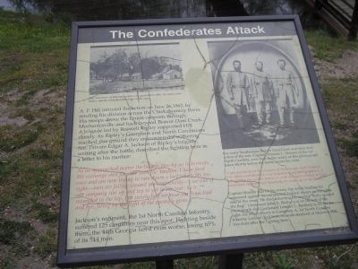
A. P. Hill initiated the action on June 26, 1862, by sending his division across the Chickahominy River. His troops drove the Union outposts through Mechanicsville and back beyond Beaver Dam Creek. A brigade led by Roswell Ripley supported Hill closely. As Ripley’s Georgians and North Carolinians reached this ground they encountered a withering fire. Private Edgar A. Jackson of Ripley’s brigade, writing after the battle, described the fighting here in a letter to his mother:
As we approached nearer the bullets flew by us in torrents. We exchange shot for shot with the Yankees. I have fired once and am now trying to ram down a ball which fits too tight – men are falling around me continually – I see one of our company rise up and try to get to the rear; he is wounded in the hip. For nearly half an hour our boys load and fire, firing by the light of the enemy’s guns.
Jackson’s regiment, the 1st North Carolina Infantry, suffered 125 casualties near this spot. Fighting beside them, the 44th Georgia fared even worse, losing 65% of its 514 men.
For many Southerners Beaver Dam Creek was their first action of the war. Captain Tristram L. Skinner of the 1st North Carolina, seen here in the center of this photograph taken shortly before the battle, wrote his wife:
“I am confident of the success of our troops – but I cannot feel either confident or very hopeful of my being spared … I will go into the action however with as brave a heart as I can command, determined cheerfully to come up to the mark.”
Captain Skinner was hit by enemy fire while leading his command against the entrenched Federal troops on the other side of the creek. He died exhorting his men to “Rally around the flag!” Lieutenant John A. Benbury is on the left of the photograph and Lieutenant Lemuel C. Benbury is on the far right. All were officers in Company A, 1st North Carolina Infantry. Lemuel died from wounds received at Malvern Hill five days after the fighting here.
Erected by Richmond National Battlefield Park - National Park Service.
Topics. This historical marker is listed in this topic list: War, US Civil. A significant historical date for this entry is June 26, 1862.
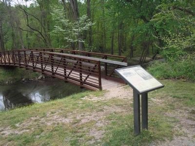
Location. Marker has been reported missing. It was located near 37° 35.718′ N, 77° 21.554′ W. Marker was in Mechanicsville, Virginia, in Hanover County. Marker could be reached from Cold Harbor Road (Virginia Route 156), on the right when traveling east. Marker is in the Beaver Dam Creek Unit of Richmond National Battlefield Park. Touch for map. Marker was in this post office area: Mechanicsville VA 23111, United States of America. Touch for directions.
Other nearby markers. At least
8 other markers are within walking distance of this location. Beaver Dam Creek (within shouting distance of this marker); Historic Cold Harbor Road (within shouting distance of this marker); Lee’s First Strike (within shouting distance of this marker); Holding the High Ground (about 300 feet away, measured in a direct line); Site of Ellerson’s Mill (about 300 feet away); a different marker also named Beaver Dam Creek (about 400 feet away); Ellerson's Mill (approx. 0.2 miles away); Seven Days Battles (approx. ¼ mile away). Touch for a list and map of all markers in Mechanicsville.
More about this marker. The upper left of the marker contains a war-time photograph with the caption “The little town of Mechanicsville as it appeared in 1865. Its name came from a cluster of blacksmith shops in the area.” The upper right of the marker features a photograph of Confederate officers Lt. John A. Benbury, Capt. Tristram L. Skinner and Lt. Lemuel C Benbury, all from Company A, 1st North Carolina Infantry. Their stories can be read above in the text of the marker.
Regarding The Confederates Attack. The marker indicates that Lemuel Benbury died in the battle, but burial records refute that, and show John Avery Benbury, his brother, was killed in the battle.
This marker has been
removed but has NOT been replaced by another marker.
Also see . . .
1. Beaver Dam Creek. CWSAC Battle Summaries website. (Submitted on January 4, 2009, by Bill Coughlin of Woodland Park, New Jersey.)
2. Places To Go in Richmond National Battlefield Park. National Park Service website. (Submitted on January 4, 2009, by Bill Coughlin of Woodland Park, New Jersey.)
3. The Seven Days Battle. HistoryCentral.com website. (Submitted on January 4, 2009, by Bill Coughlin of Woodland Park, New Jersey.)
Credits. This page was last revised on June 16, 2016. It was originally submitted on January 4, 2009, by Bill Coughlin of Woodland Park, New Jersey. This page has been viewed 1,741 times since then and 8 times this year. Last updated on December 15, 2014. Photos: 1, 2, 3. submitted on January 4, 2009, by Bill Coughlin of Woodland Park, New Jersey. 4. submitted on December 20, 2014. • Bill Pfingsten was the editor who published this page.


