Near Grand Island in Hall County, Nebraska — The American Midwest (Upper Plains)
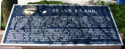
Grand Island
In 1857 a town company composed mainly of Germans settled the area north of the island. This first Grand Island failed to develop when the company became bankrupt. Present Grand Island was not platted until 1866, when the Union Pacific Railroad reached Hall County. The town grew rapidly and became the county seat. In 1869 a U.S. General Land Office was established to record land filings for the region north of the Platte. Grand Island was incorporated in 1872, and it has became a major industrial and agricultural city in the central Platte Valley.
Erected by Hall County Historical Society, Department of Roads, and Nebraska State Historical Society. (Marker Number 172.)
Topics and series. This historical marker is listed in these topic lists: Exploration • Native Americans • Settlements & Settlers • Waterways & Vessels. In addition, it is included in the Nebraska State Historical Society series list. A significant historical year for this entry is 1843.
Location. 40° 49.303′ N, 98° 17.722′ W. Marker is near Grand Island, Nebraska, in Hall County. Marker is on Interstate 80 at milepost 316.5, on the right when traveling west. Touch for map. Marker is at or near this postal address: Grand Island I-80 Rest Area Westbound, Doniphan NE 68832, United States of America. Touch for directions.
Other nearby markers. At least 8 other markers are within 6 miles of this marker, measured as the crow flies. The Mormon Trail (a few steps from this marker); The Purple Heart (a few steps from this marker); a different marker also named Grand Island (approx. 1.6 miles away); Sinclair Tank Wagon, 1917 (approx. 4˝ miles away); The Pawnee: Prairie Town Builders, Pawnee History (approx. 5.9 miles away); Earth Lodge Design and Construction (approx. 5.9 miles away); Old California Overland Trail (approx. 5.9 miles away); a different marker also named Mormon Trail (approx. 5.9 miles away). Touch for a list and map of all markers in Grand Island.
Also see . . . Geologic Studies of the Platte River. (Submitted on December 16, 2014, by William Fischer, Jr. of Scranton, Pennsylvania.)
Credits. This page was last revised on June 29, 2021. It was originally submitted on December 16, 2014, by William Fischer, Jr. of Scranton, Pennsylvania. This page has been viewed 485 times since then and 13 times this year. Photos: 1, 2. submitted on December 16, 2014, by William Fischer, Jr. of Scranton, Pennsylvania.

