Dade County
[Side A]
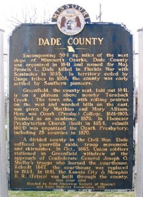
Encompassing 504 sq. miles of the west slope of Missouri's Ozarks, Dade County was organized in 1841 and named for Maj. Francis L. Dade killed in Florida War with Seminoles in 1835. In territory ceded by Osage tribes in 1808, the county was early settled by Southern pioneers.
Greenfield, the county seat, laid out 1841, is on a plateau above nearby Turnback Creek. The town site, with rolling prairies on the west and wooded hills on the east, was given by Matthias and Mary Allison. Here was Ozark (Presby.) College, 1881-1903, founded as an academy, 1870. In Ebenezer Presbyterian Church (built in 1854, rebuilt 1884) was organized the Ozark Presbytery, including 25 counties in 1870.
A divided county in the Civil War, Dade suffered guerrilla raids, troop movement, and skirmishes. In Oct., 1863, Union soldiers stationed in Greenfield withdrew at the approach of Confederate General Joseph O. Shelby's troops who burned the courthouse. Rebuilt 1867, the courthouse was replaced in 1934. In 1881, the Kansas City & Memphis R.R. (Frisco) was built through the county.
(See other side)
[Side B]
(Continued from other side)
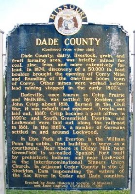
Dade County, dairy, livestock, grain, and fruit farming area, was briefly mined for coal, zinc, iron, and more extensively for lead. In 1874, discovery of a 50,000 lbs. lead
Dadeville, once known as Crisp Prairie and Mellville, was settled by Redden and John Crisp about 1818. Burned in the Civil War, it was rebuilt and renamed. Arcola was laid out, 1880; Crisp became a post office in 1890's; and South Greenfield, Everton, and Lockwood were laid out along the railroad in 1881. In the 1880's a number of Germans settled in and around Lockwood.
In Dye Park at Everton is the William Penn log cabin, first building to serve as a courthouse. Near there is Dilday Mill; near Greenfield is so-called Spanish Fort built by prehistoric Indians; and near Lockwood is the interdenominational Sinners Union Church. In adjacent Cedar County is site of Stockton Dam impounding the waters of the Sac River in Cedar and Dade Counties.
Erected 1961 by State Historical Society of Missouri and State Highway Commission.
Topics and series. This historical marker is listed in these topic lists: Agriculture • Industry & Commerce • Settlements & Settlers • War, US Civil. In addition, it is included in the Missouri, The State Historical Society of series list. A significant historical year for this entry is 1841.
Location. 37° 25.211′
Other nearby markers. At least 4 other markers are within walking distance of this marker. Freemason Veterans Memorial (approx. 0.4 miles away); Veterans Memorial (approx. 0.4 miles away); World War I Memorial (approx. 0.4 miles away); a different marker also named Veterans Memorial (approx. 0.4 miles away).
Also see . . .
1. Dade County MO History and Heritage. (Submitted on December 20, 2014, by William Fischer, Jr. of Scranton, Pennsylvania.)
2. Dade County MO at Wikipedia. (Submitted on December 20, 2014, by William Fischer, Jr. of Scranton, Pennsylvania.)
Credits. This page was last revised on August 25, 2019. It was originally submitted on December 20, 2014, by William Fischer, Jr. of Scranton, Pennsylvania. This page has been viewed 819 times since then and 112 times this year. Photos: 1, 2, 3. submitted on December 20, 2014, by William Fischer, Jr. of Scranton, Pennsylvania.


