Lock Haven in Clinton County, Pennsylvania — The American Northeast (Mid-Atlantic)
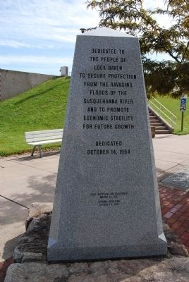
Lock Haven Flood Protection Project
Dedicated
October 14, 1994
Local Cooperation Agreement
March 14, 1991
Ground Breaking
October 3, 1991
Erected 1994.
Topics. This historical marker is listed in these topic lists: Man-Made Features • Waterways & Vessels. A significant historical month for this entry is March 1791.
Location. 41° 8.281′ N, 77° 26.523′ W. Marker is in Lock Haven, Pennsylvania, in Clinton County. Marker is at the intersection of North Jay Street (Pennsylvania Route 120) and East Water Street, on the right when traveling north on North Jay Street. Touch for map. Marker is in this post office area: Lock Haven PA 17745, United States of America. Touch for directions.
Other nearby markers. At least 8 other markers are within walking distance of this marker. Fort Reed Stockade (a few steps from this marker); The Susquehanna Greenway (a few steps from this marker); Clinton County (within shouting distance of this marker); American Hero (within shouting distance of this marker); Clinton County Veterans Memorial (within shouting distance of this marker); Lock Haven (about 300 feet away, measured in a direct line); Pennsylvania Canal (about 500 feet away); Harmon Field (approx. 0.6 miles away). Touch for a list and map of all markers in Lock Haven.

Photographed By Mike Wintermantel, May 27, 2013
2. Lock Haven Flood Protection Project Marker
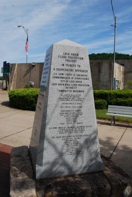
Lock Haven Flood Protection Project
In Tribute to a cooperative approach
U.S. Army Corps of Engineers
Commonwealth of Pennsylvania
City of Lock Haven
Lock Haven Area Flood Protection Authority
Township of Woodward
see photo for remaining text

Photographed By Mike Wintermantel, May 27, 2013
3. Lock Haven Flood Protection Project Marker
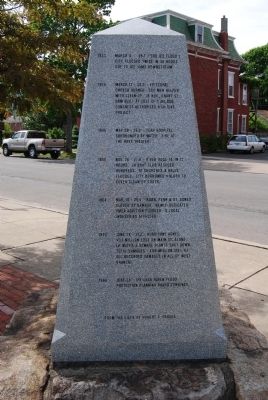
Through the years Lock Haven has suffered from floods, eighteen of which were over 25 feet. Those floods have left the people of Lock Haven robbed of their homes, possessions and means of life.
1744 Floods of unrecorded height,
1758 but noted historically for their
1772 destruction.
1784 March 15, 1784 - The 1st "Ice Flood"
1786 Oct. 1786 - The 1st "Pumpkin Flood"
1800
1829 Many local bridges damaged or
1846 destroyed
1847 Oct. 9, 1847 - 34.7' - 4' higher than
any previous flood.
The "2nd Pumpkin Flood"
1851 July 18 & 19 - 48 hrs. of raging
storms caused flood higher than
previous years.
1865 March 17 - 25.67' 2 million in damage.
Bridges from Farrandsville to
Northumberland destroyed.
1889 June 1 - 33.1" rain fell for 49 hours.
3/4 of city was inundated. The Jay St.
Bridge was the only one left between
here and Sunbury. Marked the end of
the West Branch Canal.
1894 May 31 - 26.4' Thunderbolts and fire
accompanied flooding.
1918 Feb. 21 - 26.8' "2nd Ice Flood" cakes
of ice were 12' in depth.

Photographed By Mike Wintermantel, May 27, 2013
4. Lock Haven Flood Protection Project Marker
1923 March 4 - 25.1' ("3rd Ice Flood")
city flooded twice in 48 hours
due to ice jams downstream.
1936 March 17 - 32.3' - Episcopal
church burned. CCC men helped
with clean-up. In Nov., Grant St.
Dam built at cost of $184,950.
Congress authorized a LH dike
project.
1946 May 28 - 26.2' - TEAH Hospital
surrounded by water. Fire at
the Roxy Theater.
1950 Nov. 26 - 27.8' - river rose 14' in 12
hours. LH Boat Club rescued
hundreds. 18 churches and halls
flooded. City borrowed $10,000 to
cover clean-up costs.
1964 Mar. 10 - 26.5' - Robb, Penn & St. Agnes
closed by damage. Newly-dedicated
YMCA addition flooded. 6 local
industries affected.
1972 June 24 - 31.3' - Hurricane Agnes.
$3.1 million loss on Main St. alone.
LH water and sewage plants shut down.
Total damages-$88 million (25% of
all recorded damages in all of West
Branch).
1980 June 24 - Lock Haven Flood
Protection Planning Board convenes.
Credits. This page was last revised on June 5, 2020. It was originally submitted on December 30, 2014, by Mike Wintermantel of Pittsburgh, Pennsylvania. This page has been viewed 503 times since then and 42 times this year. Photos: 1, 2, 3, 4, 5. submitted on December 30, 2014, by Mike Wintermantel of Pittsburgh, Pennsylvania.

