Near Pensacola Beach in Escambia County, Florida — The American South (South Atlantic)
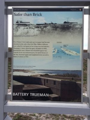
Battery Trueman
Safer than Brick
— Fort Pickens —
Fort Pickens' brick walls and cast-iron guns had become obsolete by the end of the Civil War. Harbor defenses now called for steel guns in low-lying concrete batteries. Trueman's 3-inch, rapid-fire guns, mounted in 1905, guarded the inner channel and minefield against fast torpedo boats and minesweepers, the latest threats of the day. Truman's guns and equipment were moved to Battery Cullum in 1943.
Erected by National Park Service, Department of the Interior.
Topics. This historical marker is listed in these topic lists: Forts and Castles • Waterways & Vessels. A significant historical year for this entry is 1905.
Location. 30° 19.844′ N, 87° 17.705′ W. Marker is near Pensacola Beach, Florida, in Escambia County. Marker is on Fort Pickens Road, 10 miles west of Pensacola Beach Boulevard (State Road 399), on the left when traveling west. Touch for map. Marker is at or near this postal address: Fort Pickens Road, Gulf Breeze FL 32561, United States of America. Touch for directions.
Other nearby markers. At least 8 other markers are within walking distance of this marker. Hurricane Ivan (approx. 0.2 miles away); Colonial Power Struggle (approx. 0.2 miles away); Battery Payne (approx. 0.2 miles away); Battery Van Swearingen (approx. ¼ mile away); Battery Cullum, Battery Sevier (approx. ¼ mile away); Beefing Up Defenses (approx. 0.3 miles away); Dueling with Confederates (approx. 0.3 miles away); Swatting Mosquitoes (approx. 0.3 miles away). Touch for a list and map of all markers in Pensacola Beach.
Also see . . . Fort Wiki article. (Submitted on January 2, 2015, by Mark Hilton of Montgomery, Alabama.)
Credits. This page was last revised on July 29, 2020. It was originally submitted on January 2, 2015, by Mark Hilton of Montgomery, Alabama. This page has been viewed 386 times since then and 12 times this year. Photos: 1, 2, 3, 4. submitted on January 2, 2015, by Mark Hilton of Montgomery, Alabama.


