Namur in Door County, Wisconsin — The American Midwest (Great Lakes)
Transportation Archaeology on the WIS 57 Project
From First Americans to Euroamericans
Archaeology and History of the WIS 57 Transportation Corridor
Inscription.
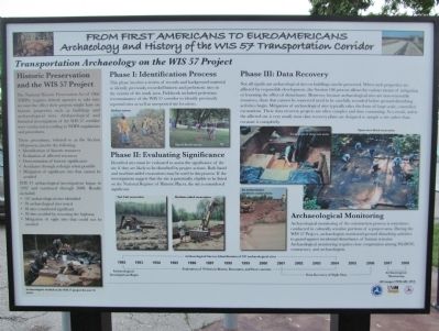
Historic Preservation and the WIS 57 Project
The National Historic Preservation Act of 1966 (NHPA) requires federal agencies to take into account the effect their projects might have on historic properties such as buildings and archaeological sites. Archaeological and historical investigations of the WIS 57 corridor were conducted according to NHPA regulations and procedures.
These procedures, referred to as the Section 106 process, involve the following:
Identification of historic resources
Evaluation of affected resources
Determination of historic significance
Avoidance through redesign when possible
Mitigation of significant sites that cannot be avoided
WIS 57 archaeological investigations began in 1992 and continued through 2008. Results included:
107 archaeological sites identified
78 archaeological sites tested
38 sites considered significant
30 sites avoided by rerouting the highway
Mitigation of eight sites that could not be avoided
Phase I: Identification Process
This phase involves a review of records and background material to identify previously recorded historic and prehistoric sites in the vicinity of the study area. Fieldwork included pedestrian reconnaissance of the WIS 57 corridor to identify previously reported sites as well as unreported site locations.
Phase II: Evaluating Significance
Identified sites must be evaluated to assess the significance of the site if they are likely to be disturbed by project actions. Both hand and machine-aided excavations may be used in this process. If the investigations suggest that the site is potentially eligible to be listed on the National Register of Historic Places, the site is considered significant.
Phase III: Data Recovery
Not all significant archaeological sites or buildings can be preserved. When such properties are affected by responsible development, the Section 106 process allows for various means of mitigating or lessening the effect of disturbance. However, because archaeological sites are non-renewable resources, those that cannot be conserved need to be carefully recorded before ground-disturbing activities begin. Mitigation of archaeological sites typically takes the form of large-scale, controlled excavations. These data recovery projects are often complex and time consuming. As a result, unless the affected site is very small, most data recovery plans are designed to sample a site rather than excavate it completely.
Archaeological Monitoring
Archaeological
monitoring of the construction process is sometimes conducted in culturally sensitive portions of a project area. During the WIS 57 Project, archaeologists monitored ground disturbing activities
to guard against incidental disturbance of human remains. "Archaeological monitoring requires close cooperation among WisDOT, contractors, and archaeologists.
(All images UWM-ARL 2012)
logos of United States Department of Transportation, University of Wisconsin–Milwaukee, Wisconsin Department of Transportation
Erected 2012 by U.S. Department of Transportation, University of Wisconsin–Milwaukee, Wisconsin Department of Transportation.
Topics. This historical marker is listed in these topic lists: Anthropology & Archaeology • Roads & Vehicles. A significant historical year for this entry is 1966.
Location. 44° 44.063′ N, 87° 40.018′ W. Marker is in Namur, Wisconsin, in Door County. Marker is on County Road DK east of County Road N, on the left when traveling east. Marker is immediately southwest of the Belgian Heritage Center, formerly Our Lady of the Snows Church. Touch for map. Marker is at or near this postal address: 1255 County Road DK, Brussels WI 54204, United States of America. Touch for directions.
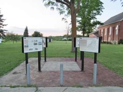
Other nearby markers. At least 8 other markers are within 3 miles of this marker, measured as the crow flies. The WIS 57 Reconstruction Project in Brown, Kewaunee, and Door Counties (here, next to this marker); Namur and the Norbertine Fathers: Community, Education, and Religion among Belgian-Americans (here, next to this marker); Architecture and History in the WIS 57 Project Area (here, next to this marker); Historic Euroamerican Settlement of the Door Peninsula (here, next to this marker); After the Fire: The Vandermissen Brickworks Site (here, next to this marker); The Fire of 1871 and Williamsonville: A 19th Century Euroamerican Settlement in Door County (here, next to this marker); Belgian Settlement in Wisconsin (within shouting distance of this marker); The Brussels Cemetery Grotto (approx. 2½ miles away). Touch for a list and map of all markers in Namur.
More about this marker. photo captions, clockwise:
Surface survey
Shovel Probe survey
Excavation of deep test units
Open area block excavation
An archaeologist monitors construction.
Machine-aided excavations
Test Unit excavation
Archaeologists worked on the WIS 57 project for over 15 years.
An "Archaeological Survey-Identification of 107 archaeological sites" 1992-2008 timeline is shown at the bottom of the panel.
Also see . . .
1. Brick by Brick: A Comparative pXRF Analysis of Brickworks and Structures. University of Wisconsin-Milwaukee. (Submitted on January 16, 2015.)
2. Namur Belgian-American District National Register Nomination. (Submitted on January 21, 2020, by William Fischer, Jr. of Scranton, Pennsylvania.)
Additional keywords. Transportation Archaeology on the WIS 57 Project
Credits. This page was last revised on June 14, 2020. It was originally submitted on January 16, 2015, by Keith L of Wisconsin Rapids, Wisconsin. This page has been viewed 458 times since then and 16 times this year. Photos: 1, 2. submitted on January 16, 2015, by Keith L of Wisconsin Rapids, Wisconsin.

