Old Town North in Alexandria, Virginia — The American South (Mid-Atlantic)
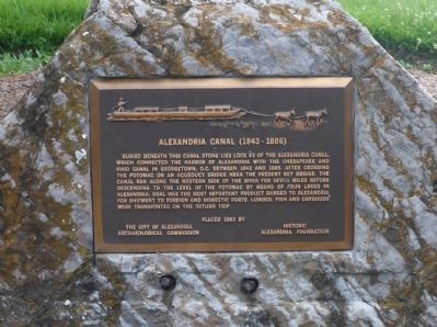
Alexandria Canal (1843 - 1886)
Lock #3
Erected 1983 by The City of Alexandria Archaeological Commission / Historic Alexandria Foundation.
Topics and series. This historical marker is listed in these topic lists: Industry & Commerce • Man-Made Features • Waterways & Vessels. In addition, it is included in the Chesapeake and Ohio (C&O) Canal series list. A significant historical year for this entry is 1843.
Location. 38° 48.85′ N, 77° 2.488′ W. Marker is in Alexandria, Virginia. It is in Old Town North. Marker is on North Royal Street north of Montgomery Street, on the right when traveling north. The marker is located on east side of Montgomery Park. It stands in the Old Town North neighborhood of Alexandria. Touch for map. Marker is at or near this postal address: 945 North Royal Street, Alexandria VA 22314, United States of America. Touch for directions.
Other nearby markers. At least 8 other markers are within walking distance of this marker. Remnants of Lock #4 of the Alexandria Canal (about 300 feet away, measured in a direct line); Cross Canal (about 400 feet away); The Tale of Spa Spring (about 400 feet away); Alexandria Canal Turning Basin (about 500 feet away); The Alexandria Canal Company, 1830 - 1886 (about 500 feet away); The Old Dominion Glass Company (about 600 feet away); Cross Canal Neighborhood, 1860s - 1960s (about 600 feet away); Tide Lock of the Alexandria Canal (approx. 0.2 miles away). Touch for a list and map of all markers in Alexandria.
Also see . . . Alexandria Canal (Virginia). Wikipedia (Submitted on February 8, 2015.)
Credits. This page was last revised on January 27, 2023. It was originally submitted on February 7, 2015, by Anthony Kupec of Alexandria, Virginia. This page has been viewed 964 times since then and 45 times this year. Photos: 1. submitted on February 7, 2015, by Anthony Kupec of Alexandria, Virginia. 2. submitted on April 6, 2015, by J. Makali Bruton of Accra, Ghana. • Bernard Fisher was the editor who published this page.

