Wamego in Pottawatomie County, Kansas — The American Midwest (Upper Plains)
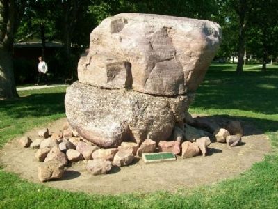
Sand and Quartz Boulder
This 20-ton boulder was found on the John Winter farm 9 miles NW of Wamego and brought here by wagon in 1907. Believed to be 40 million years old, its sand and quartz content were polished by glacial action.
Erected by City of Wamego.
Topics. This historical marker is listed in this topic list: Environment. A significant historical year for this entry is 1907.
Location. 39° 12.156′ N, 96° 18.136′ W. Marker is in Wamego, Kansas, in Pottawatomie County. Marker and boulder are in the City Park. Touch for map. Marker is at or near this postal address: 500 Ash Street, Wamego KS 66547, United States of America. Touch for directions.
Other nearby markers. At least 8 other markers are within 6 miles of this marker, measured as the crow flies. 1893 Chicago World's Fair Statues (a few steps from this marker); Old Dutch Mill (about 500 feet away, measured in a direct line); World War Memorial (about 600 feet away); Pottawatomie County (about 600 feet away); Colonel Raymond E. Morris, USAF Retired (approx. 0.2 miles away); War Memorial (approx. ¾ mile away); Vieux Cemetery (approx. 4.7 miles away); The Vieux Crossing (approx. 5.4 miles away). Touch for a list and map of all markers in Wamego.
Also see . . .
1. Wamego City Park. City website entry (Submitted on February 18, 2015, by William Fischer, Jr. of Scranton, Pennsylvania.)
2. Kansas's Glaciated Region. GeoKansas website entry (Submitted on February 18, 2015, by William Fischer, Jr. of Scranton, Pennsylvania.)
3. Glaciers in Kansas. Kansas Geological Survey website entry (Submitted on February 18, 2015, by William Fischer, Jr. of Scranton, Pennsylvania.)
4. Glaciation. Encyclopedia of the Great Plains website entry (Submitted on February 18, 2015, by William Fischer, Jr. of Scranton, Pennsylvania.)
Credits. This page was last revised on January 28, 2022. It was originally submitted on February 18, 2015, by William Fischer, Jr. of Scranton, Pennsylvania. This page has been viewed 362 times since then and 24 times this year. Photos: 1, 2. submitted on February 18, 2015, by William Fischer, Jr. of Scranton, Pennsylvania.

