Montcalm in Québec in Communauté-Urbaine-de-Québec, — Central Canada (French-Canadian)
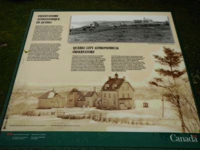
Quebec City Astronomical Observatory
Observatoire Astronomique de Québec

Photographed By Barry Swackhamer, July 25, 2014
1. Quebec City Astronomical Observatory Marker
Captions (English / French): (top) Astronomical Observatory and Prison, before 1908. / Observatoire astronomique et prison, avant 1908.; (bottom) Astronomical Observatory, 1936. / Observatoire astronomique, 1936.
The Quebec City Astronomical Observatory was officially established at the Citadel in 1850 by the Department of Marine and Fisheries in order to give the exact time to sailors on the many ships anchored at the port. In 1864, an equatorial telescope was installed in a quadrangular tower specially built for that purpose on farmland located on the Plains of Abraham. The Observatory’s director, Commander Edward David Ashe, set up an office in the farm building. A decade later, the Astronomical Observatory was move to the to the Plains of Abraham. A residence was built and the instruments were assembled in three annexes connected to the existing tower.
In the 20th century, as the means of communication developed. particularly radio, navigators favored observatories in Victoria and Ottawa, which broadcast across Canada, over the Quebec Observatory. In 1930, the Quebec City Observatory made meteorology its priority. The information gathered was used by airlines and for forest protection, road safety, and river and ocean navigation. In 1936, these services were transferred to a brand new weather station nearby, and the Astronomical Observatory buildings were demolished, making it easier to incorporate the site into the National Battlefields Park.
French:
L’observatoire astronomique de Québec est implanté officiellement à la Citadelle en 1850 par le département de la Marine et des Pêcheries afin de donner l’heure exacte aux marins et des nombreux navires que fréquent le port. En 1864, un télescope équatorial est installé dans une tour quadrangulaire spécialement construite à cette fin sur le terrain occupé par une ferme, sur les plaines d’Abraham. Le directeur de l’Observatoire, le commandant Edward David Ashe, improvise alors un bureau dans un des bâtiments de cette ferme. Dix ans plus tard, l’Observatoire astronomique déménage sur les plaines d’Abraham: une résidence est construite et les instruments sont regroupés dans trois annexes reliées à la tour précédemment érigée.
Au XXᵉ siècle, l’evolution des moyens de communication principalement de la radio, fait en sorte que les navigateurs délaissent l’Observatoire de Quebec au profit de ceux de Victoria ed d’Ottawa. qui diffusent dans tout le Canada. En 1930, pour l’Observatoire de Québec. la priorité devient météorologique plutôt qu’astronomique. Les renseignements recueillis serviront désormais a la protection forestière et à la sécurité routière, aux lignes aériennes ainsi qu’a la navigation fluviale et océanique. En 1936, ces services sont transférés non loin dans une toute nouvelle station météorologique, entraînant la démolition des bâtiments de l’Observatoire astronomique et facilitant l’intégration du site au par des Camps-de-Bataille.
Erected by Parks Canada Parcs & National Battlefields Commission / Commission des champs de bataille nationaux.
Topics. This historical marker is listed in this topic list: Science & Medicine. A significant historical year for this entry is 1850.
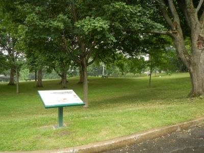
Location. 46° 48.055′ N, 71° 13.306′ W. Marker is in Québec, in Communauté-Urbaine-de-Québec. It is in Montcalm. Marker is at the intersection of Avenue George VI and Rue Garneau, on the left when traveling east on Avenue George VI. Touch for map. Marker is in this post office area: Québec G1R 2L3, Canada. Touch for directions.
Other nearby markers. At least 8 other markers are within walking distance of this marker. Bragg’s 28th Foot, (within shouting distance of this marker); Here, on the very eve of victory (within shouting distance of this marker); The “Louisbourg Grenadiers” (about 90 meters away, measured in a direct line); The / Le Royal Roussillon, (about 90 meters away); Cornelius Krieghoff (about 180 meters away); Pavillon Charles-Baillairgé (about 210 meters away); Frederick G. Todd (about 240 meters away); La Maison Henry-Stuart / Henry-Stuart House (approx. 0.2 kilometers away). Touch for a list and map of all markers in Québec.
Credits. This page was last revised on February 9, 2023. It was originally submitted on February 19, 2015, by Barry Swackhamer of Brentwood, California. This page has been viewed 392 times since then and 23 times this year. Photos: 1, 2. submitted on February 19, 2015, by Barry Swackhamer of Brentwood, California. • Andrew Ruppenstein was the editor who published this page.
