Crossroads of Kansas
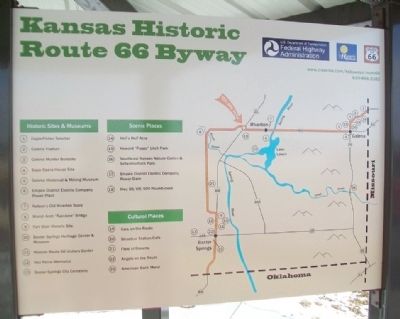
Kansas Historic Route 66 Byway
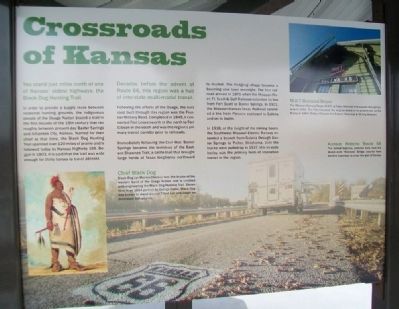
You stand just miles north of one of Kansas' oldest highways: the Black Dog Hunting Trail.
In order to provide a supply route between seasonal hunting grounds, the indigenous people of the Osage Nation blazed a trail in the first decade of the 19th century that ran roughly between present-day Baxter Springs and Arkansas City, Kansas. Named for their chief at that time, the Black Dog Hunting Trail spanned over 120 miles of prairie and is followed today by Kansas Highway 166. Begun in 1803, it is said that the trail was wide enought for thirty horses to travel abreast.
Decades before the advent of Route 66, this region was a hub of interstate multi-modal transit.
Following the efforts of the Osage, the next road built through this region was the Frontier Military Road. Completed in 1845, it connected Fort Leavenworth in the north to Fort Gibson in the south and was the region's primary transit corridor prior to railroads.
Immediately following the Civil War, Baxter Springs became the terminus of the Eastern Shawnee Trail, a cattle trail that brought large herds of Texas longhorns northward to market. The fledgling village became a booming cow town overnight. The first railroad arrived in 1870 when the Missouri River, Ft. Scott & Gulf Railroad extended its line from Fort Scott to Baxter Springs. In 1901,
the Missouri-Kansas-Texas Railroad extended a line from Parsons eastward to Galena and on to Joplin.In 1918, at the height of the mining boom, the Southwest Missouri Electric Railway extended a branch from Galena through Baxter Springs to Picher, Oklahoma. Until the tracks were pulled up in 1937, this tri-state trolley was the primary form of interurban transit in the region.
[Photo captions read]
Chief Black Dog
Black Dog (or Manka-Chonka) was the leader of the western band of the Osage Nation and is credited with engineering the Black Dog Hunting Trail. Shown here in an 1834 portrait by George Catlin, Black Dog was known to stand around 7 feet tall and weigh an estimated 300 pounds.
M-K-T Railroad Depot
The Missouri-Kansas-Texas (M-K-T, or Katy) Railroad first passed through Galena in 1901. The City relocated the original depot to its present site on the Byway in 1984. Today it houses the Galena Historical & Mining Museum.
Kansas Historic Route 66
The famed highway, pictured here near the Marsh Arch "Rainbow" Bridge, was far from the first travelway to cross this part of Kansas
Erected 2014 by USDOT Federal Highway Administration and the State of Kansas.
Topics and series. This historical marker is listed in these topic lists: Industry & Commerce
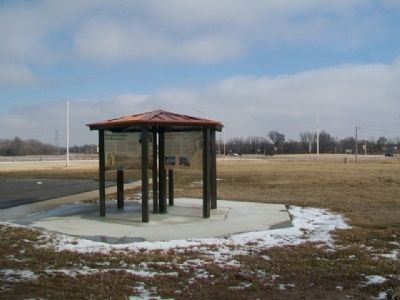
Location. 37° 4.54′ N, 94° 43.039′ W. Marker is in Riverton, Kansas, in Cherokee County. Marker is at the intersection of U.S. 400 and State Highway 66, on the right when traveling south on U.S. 400. Marker kiosk is about 300 feet west of the roundabout. Touch for map. Marker is in this post office area: Riverton KS 66770, United States of America. Touch for directions.
Other nearby markers. At least 8 other markers are within walking distance of this marker. Bridging the American Divide (here, next to this marker); Boom Towns (here, next to this marker); Cosmopolitan Corner (here, next to this marker); Land's Legacy (here, next to this marker); Baxter Springs Massacre and Today (a few steps from this marker); Fort Blair (a few steps from this marker); Where Two Roads Converge (a few steps from this marker); Baxter Springs Massacre (approx. 0.8 miles away). Touch for a list and map of all markers in Riverton.
Also see . . .
1. Osage Nation. (Submitted on February 28, 2015, by William Fischer, Jr. of Scranton, Pennsylvania.)
2. Fort Leavenworth-Fort Gibson Military Road. (Submitted on February 28, 2015, by William Fischer, Jr. of Scranton, Pennsylvania.)
3. Kansas' First Cowtown. (Submitted on February 28, 2015, by William Fischer, Jr. of Scranton, Pennsylvania.)
4. Missouri River, Fort Scott and Gulf Railroad map of the Cherokee neutral lands, Kansas. (Submitted on February 28, 2015, by William Fischer, Jr. of Scranton, Pennsylvania.)
5. Southwest Missouri Electric Railway Company. (Submitted on February 28, 2015, by William Fischer, Jr. of Scranton, Pennsylvania.)
6. Galena Mining and Historical Museum at Facebook. (Submitted on February 28, 2015, by William Fischer, Jr. of Scranton, Pennsylvania.)
7. Kansas' Historic Route 66 Byway. (Submitted on February 28, 2015, by William Fischer, Jr. of Scranton, Pennsylvania.)
Credits. This page was last revised on February 19, 2024. It was originally submitted on February 28, 2015, by William Fischer, Jr. of Scranton, Pennsylvania. This page has been viewed 454 times since then and 10 times this year. Photos: 1. submitted on February 28, 2015, by William Fischer, Jr. of Scranton, Pennsylvania. 2, 3. submitted on February 26, 2015, by William Fischer, Jr. of Scranton, Pennsylvania.


