Chambly in La Vallée-du-Richelieu, Québec — Central Canada (French-Canadian)
Fort Chambly
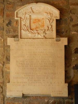
Courage et Loyaute
Sous le regne de Louis XIV,
Roi de France et de Navarre,
Le Marquis de Vaudreuh,
Etant
Gouverneur général de la Nouvelle France
Ce Fort fut érige en 1771
Incendié en 1776.
Restauré par Guy Carleton en 1777.
Abandonné en 1817
Il fut réparé en 1882 et 1888;
Sous le regne de Victoria,
Reine de la Grande Bretagne.
Le Marquis de Lorne
Etant
Gouverneur Général du Canada
Théodore Robitaille,
Lieutenant Gouverneur de Québec.
Par ordre de
Sir Hector Langevin C. B. C. C. M. G.
Ministre des Travaux Publics du Canada.
English translation:
Courage and Loyalty
Under the reign of Louis XIV
King of France and Navarre
The Marquis of Vaudreuh
As
Governor General of New France
This fort was erected in 1771
Destroyed by fire in 1776.
Restored by Guy Carleton in 1777.
Abandoned in 1817
It was repaired in 1882 and 1888;
Under Victoria's reign,
Queen of Great Britain.
The Marquis of Lorne
As
Governor General of Canada
Théodore Robitaille
Lieutenant Governor of Quebec.
By order of
Sir Hector Langevin C. B. C. C. Mr. G.
Minister of Public Works Canada.
Erected by Minister of Public Works Canada.
Topics. This historical marker is listed in these topic lists: Forts and Castles • War of 1812 • War, US Revolutionary. A significant historical year for this entry is 1665.
Location. 45° 26.971′ N, 73° 16.626′ W. Marker is in Chambly, Québec, in La Vallée-du-Richelieu. Marker can be reached from Rue du Fort close to Avenue Bourgogne. Touch for map. Marker is at or near this postal address: 77 Rue du Fort, Chambly QC J3L, Canada. Touch for directions.
Other nearby markers. At least 8 other markers are within 13 kilometers of this marker, measured as the crow flies. Fort Chambly Cemetery (about 150 meters away, measured in a direct line); General John Thomas (about 150 meters away); St. Stephen's Anglican Church (approx. 0.3 kilometers away); Chambly Canal (approx. 0.6 kilometers away); Albani (approx. 1.4 kilometers away); Fort Ste. Therese (approx. 6 kilometers away); Fort Sainte-Thérèse (approx. 6.9 kilometers away); Second Battle of La Prairie (approx. 11.9 kilometers away). Touch for a list and map of all markers in Chambly.
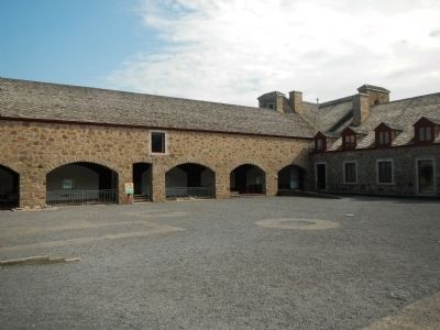
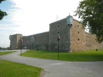
More about this marker. This marker is located at the sally-port of Fort Chambly. Fort Chambly is a part of Canal Chambly National Historic Site.
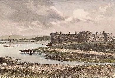
Also see . . . Fort Chambly. In 1812, yet another war broke out between Britain and the United States. Canada was British, and again the specter of invasion from the south loomed large. Fort Chambly became a major staging ground for British and Canadian forces. The fort was strengthened and a large military complex evolved around the fortress itself. Guardhouses, barracks, and administrative buildings were constructed. Soon, some 6000 troops were quartered here. It was believed the Richelieu would once again play a critical role in military strategy. Replacement for original broken link 08/11/2020 LPG (Submitted on March 28, 2015, by Barry Swackhamer of Brentwood, California.)
Credits. This page was last revised on August 11, 2020. It was originally submitted on March 28, 2015, by Barry Swackhamer of Brentwood, California. This page has been viewed 468 times since then and 13 times this year. Photos: 1, 2, 3, 4. submitted on March 28, 2015, by Barry Swackhamer of Brentwood, California. • Andrew Ruppenstein was the editor who published this page.


