Lacolle in Le Haut-Richelieu, Québec — Central Canada (French-Canadian)
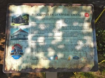
Blockhaus de la Rivière-Lacolle
Lacolle Mills Blockhouse
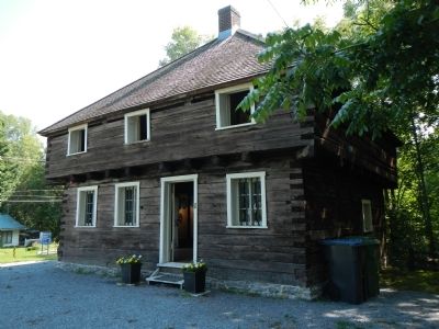
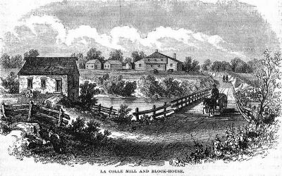
Built prior to the War of 1812, the Lacolle Blockhouse is one of the last military defense works of its kind still standing in Canada. After the American invasion of 1775 and 1776, the British authorities wished to exert better control over access to the Saint Lawrence River via the Richelieu River. In 1778, the Royal Engineers began building a defence network of forts, redoubts and blockhouses such as the one on the Lacolle River. Lacolle became an important outpost protecting the entrance to the Richelieu River. On March 30, 1814, American forces under General James Wilkinson attacked British troops entrenched in the Lacolle Mill, a strategic position close to the blockhouse. The American army of 4,000 was routed by a force of 600 British soldiers and Canadian militia. The fortification was severely tested during the battle. Less than 25 years later, On November 7, 1838, the same site witnessed one of the last confrontations between the Patriotes and loyalist volunteers during the 1837-1838 Rebellion. On November 16, 1960, the Lacolle Mills Blockhouse was classified as a heritage building by the ministère de la Culture et des Communications du Quebec. In 2007, it was listed on the Canadian Register of Historic Places.
French:
Érigé a l’époque de la guerre de 1812, le blockhaus de la Rivière-Lacolle est l’un des derniers ouvrages militaires du genre à exister au Canada.
Après les invasions américaines de 1775-1776, les autorités britanniques désirent mieux contrôler l’accès au fleuve Saint-Laurent par la rivière Richelieu. En 1778, les ingénieurs royaux entreprennent la mise en place d’un système de défense qui comprend plusieurs types d’ouvrages militaires tels que des forts, des redoutes et des blockhaus comme celui de la Rivière-Lacolle. Alcoolé constitue alors un avant-poste important qui protège l’entrée de la rivière Richelieu.
Le 30 mars 1814, le général américain James Wilkinson attaque les troupes britannique retranchées au moulin de Lacolle, position stratégique à proximité du blockhaus. L’armée américaine qui compte 4 000 hommes est mise en déroute par 600 soldats britannique et miliciens canadiens. La fortification est mise à rude épreuve lors de cette bataille.
Moins de 25 ans plus tard, c’est-à-dire le 7 novembre 1838, le meme site est témoin d’un des derniers affrontements de l’insurrection de 1837-1838 entre les Patriotes et le Volontaires.
Le 16 novembre 1960, le blockhaus de le Rivière-Lacolle est classé immeuble patrimonial par le ministère de la Culture et des Communications du Québec. En 2007, il est inscrit au répertoire des lieux patrimoniaux du Canada
Erected by Québec Culture et Communications, Tourisme Saint-Jean-sur-Richelieu. (Marker Number 15.)
Topics. This historical marker is listed in these topic lists: Forts and Castles • War of 1812. A significant historical month for this entry is March 1812.
Location. 45° 4.161′ N, 73° 20.533′ W. Marker is in Lacolle, Québec, in Le Haut-Richelieu. Marker can be reached from Montée Bowman close to Rue Principale (Québec Route 223). Touch for map. Marker is at or near this postal address: 1 Montée Bowman, Lacolle QC J0J 1J0, Canada. Touch for directions.
Other nearby markers. At least 8 other markers are within 10 kilometers of this marker, measured as the crow flies. A different marker also named Blockhaus de la Rivière-Lacolle (a few steps from this marker); Bataille du Moulin de Lacolle / Battle of the Lacolle Mill (about 210 meters away, measured in a direct line); Caldwell Manor (approx. 3.5 kilometers away); La Bataille d’Odelltown / Battle of Odelltown (approx. 4.6 kilometers away); Fort Montgomery (approx. 7.8 kilometers away in the U.S.); The Royal Navy (approx. 8.1 kilometers away); Fort Lennox (approx. 8.3 kilometers away); Working The Lake (approx. 8.6 kilometers away in the U.S.). Touch for a list and map of all markers in Lacolle.
Also see . . .
1. Lower Canada Rebellion - Wikipedia. Activists in Lower Canada began to work for reform in a period of economic disfranchisement of the French-speaking majority and working-class English-speaking citizens. The rebellion protested the injustice of colonial governing as such, in which the governor and upper house of the legislature were appointed by the Crown. Many of its leaders and participants were English-speaking citizens of Lower Canada. The French speakers felt that Anglophones were disproportionately represented in the lucrative fields of banking, the timber trade, and transportation industry. (Submitted on March 30, 2015, by Barry Swackhamer of Brentwood, California.)
2. Battle of Lacolle Mills (1814). Wilkinson marched northwards from Plattsburgh to attack this outpost on 27 March 1814. His force consisted of 4,000 men organised into three brigades, with 11 pieces of artillery. The march was delayed by deep snow and mud, and he was not able to occupy Odelltown until 30 March, and begin the attack on Lacolle Mill until the early afternoon. (Submitted on March 30, 2015, by Barry Swackhamer of Brentwood, California.)
Credits. This page was last revised on October 31, 2017. It was originally submitted on March 30, 2015, by Barry Swackhamer of Brentwood, California. This page has been viewed 446 times since then and 19 times this year. Photos: 1, 2, 3. submitted on March 30, 2015, by Barry Swackhamer of Brentwood, California. • Andrew Ruppenstein was the editor who published this page.


