Near Stamford in Haskell County, Texas — The American South (West South Central)
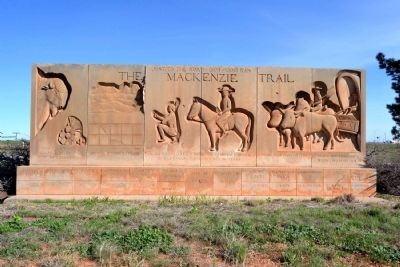
The Mackenzie Trail
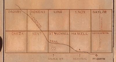
Just to the north (1874 - 1900) ran the Mackenzie Trail.
Over a million buffalo hides hauled east, route settlers west.
Main trail between T.P.-F.W. & D’rrys.
Tonkawa Indians guided Mackenzie to defeat Comanches in Tule Canyon, end Indian power in Texas.
Trail died from R.R. - 1900.
Along the trail began Longhorn ranches.
Erected 1959 by Mack–Trail Memorial Association. (Marker Number 5374.)
Topics. This historical marker is listed in these topic lists: Roads & Vehicles • Wars, US Indian. A significant historical year for this entry is 1900.
Location. 32° 58.239′ N, 99° 48.205′ W. Marker is near Stamford, Texas, in Haskell County. Marker is at the intersection of State Highway 6 and U.S. 277, on the right when traveling west on State Highway 6. Marker is at the east corner of the intersection of SH 6 and the west side frontage access road for US 277. Touch for map. Marker is in this post office area: Rule TX 79548, United States of America. Touch for directions.
Other nearby markers. At least 8 other markers are within 6 miles of this marker, measured as the crow flies. First Baptist Church (approx. 1.6 miles away); Swenson Land and Cattle Company Headquarters (approx. 1.8 miles away); Stamford (approx. 1.8 miles away); St. John's Methodist (approx. 1.9 miles away); First AQHA Show (approx. 2 miles away); "The Poet Ranchman" Larry Chittenden (approx. 2.2 miles away); Texas Cowboy Reunion Oldtimers' Association (approx. 2.2 miles away); Arledge Field (approx. 5.8 miles away). Touch for a list and map of all markers in Stamford.
More about this marker. The marker states the following:
Erected by Mack–Trail Memorial Association, Bernard Buie
Sculptor R. Saladee, Lettering W.M. Chase
Credits. This page was last revised on August 27, 2020. It was originally submitted on March 30, 2015, by Duane Hall of Abilene, Texas. This page has been viewed 1,246 times since then and 134 times this year. Photos: 1, 2, 3, 4. submitted on March 30, 2015, by Duane Hall of Abilene, Texas.


