Lachine in Montréal in Communauté-Urbaine-de-Montréal, Québec — Central Canada (French-Canadian)
An Upstream Battle
Naviguer à contre-courant

Photographed By Barry Swackhamer, August 5, 2014
1. An Upstream Battle Marker
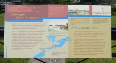
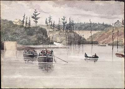
Captions (English / French): (map on bottom) Canals built by the British military between Lake St Louis and Lake St François, in 1788. / Les canaux des militaires britanniques, entre les lacs Saint-Louis et Saint-François, en 1788.; (top center) Around 1835, 1500 batteaux and 800 Durham barges, along with river boats and wooden rafts, formed the bulk of the watercraft on the upper St. Lawrence. / Vers 1835, 1500 «batteaux» et 800 barges Durham, auxquels s’ajoutent chalands de radeaux en bois, constituent l’essentiel de la batellerie du haut Saint-Laurent.; (middle center) Cascades Canal, circa 1820. / Le canal des Cascades, vers 1820.; (top right) Introduced by the French, the bateau was a a flat-bottomed boat with pointed ends and a sail. A crew of four or five en plied oars or poles as needed. The small craft measured 9 to 12 m long and 1.5 to 2.5 m wide. / Introduit par les Français, le «batteau» est un barque à fond plat, pointue aux deux bouts et munie d’une voile. Le équipage compte quatre ou cinq homes qui manient rams et perches au besoin. L’embarcation mesure de 9 m à 12 m de log sur 1.5 m à 2.5 mm de large.; The Durham barge was a flat-bottomed craft introduced by the Americans around 1800. Larger than the bateau, it differed in its rounded bow and aft-mounted rudder. Its dimensions varied from 25 to 30 m long and 3 to 4 m wide. / Le barge Durham est une embarcation à fond plat, introduite par les Américains ver 1800. Plus grosse que le «batteau», elle s’en distingue par sa proue arrondie et par son gouvernail arrière. Ses dimensions varient entre 25 m et 39 m de long et 3 m et 4 m de large.
In the early 19th century, navigators could avoid the rapids between Lake St. Louis and Lake St. François by using a number of small canals built by the military around 1780. Nothing of the sort allowed navigators to bypass the Lachine Rapids.
In 1815, the government of Lower Canada sponsored a study aimed at building a canal on Montreal Island, but implementation was delayed. Four years later, a group of businessmen led by John Richardson took over the project and formed the Company of the Proprietors of the Lachine Canal. Unable to sell enough shares to finance the project, the company was forced to withdraw. Under mounting pressure from merchants, the government finally relaunched the project. A ceremony marking the start of work was held in Lachine on July 17, 1821. The canal was officially inaugurated on August 24, 1824. However, it was not navigable along its entire length until the following year.
French:
Au début de XIXᵉ siècle, les navigateurs pouvaient éviter les rapides entre les lacs Saint-Louis et Saint-François, en empruntant quelques petites canaux construits par les militaires vers 1780. Rein de tel n’existait pour contourner les rapides de Lachine.
En 1815, le gouvernement du Bas-Canada parraine une étude visant à réaliser un canal sur l’ile de Montréal, mais en reporte la mise en oeuvre. Quatre ans plus tard, un groupe d’hommes d’affaires, dirigé par John Richardson, s’approprie le projet et forme la Company of the Proprietors of the Lachine Canal. Celle-ci doit retraiter à son tour, incapable de vendre suffisamment d’actions pour un assumer le financement. Sous les pressions grandissantes des marchands, le gouvernement réactive finalement le dossier. La cérémonie marquant le début des travaux se tient à Lachine, le 17 juillet 1821. Le canal est inauguré officiellement le 24 août 1824. Toutefois, il ne sera navigable sur toute sa longueur que l’année suivante.
Erected by Parks Canada / Parcs Canada.
Topics. This historical marker is listed in this topic list: Waterways & Vessels. A significant historical month for this entry is July 1926.
Location. 45° 25.884′ N, 73° 40.144′ W. Marker is in Montréal, Québec, in Communauté-Urbaine-de-Montréal. It is in Lachine. Marker is on Boulevard Saint-Joseph close to Chemin du Musée, on the left when traveling east. Touch for map. Marker is at or near this postal address: 600 Bd Saint-Joseph, Montréal QC H8S 2M1, Canada. Touch for directions.
Other nearby markers. At least 8 other markers are within walking distance of this marker. A Wonderful New Addition (here, next to this marker); Full Steam Ahead (within shouting distance of this marker); Growing With the Times (within shouting distance of this marker); The Lachine Canal (about 120 meters away, measured in a direct line); Frances Anne Hopkins (approx. half a kilometer away); The Hudson's Bay Company in Lachine (approx. half a kilometer away); Lachine: Gateway to the Northwest (approx. half a kilometer away); Lachine Massacre (approx. half a kilometer away). Touch for a list and map of all markers in Montréal.
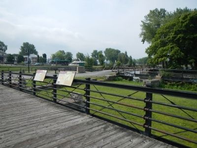
More about this marker. This marker is on a foot bridge over the line of the original Lachine Canal.
Credits. This page was last revised on February 9, 2023. It was originally submitted on April 5, 2015, by Barry Swackhamer of Brentwood, California. This page has been viewed 425 times since then and 11 times this year. Photos: 1, 2, 3. submitted on April 5, 2015, by Barry Swackhamer of Brentwood, California. • Andrew Ruppenstein was the editor who published this page.

