Julian in San Diego County, California — The American West (Pacific Coastal)
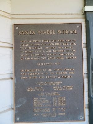
Santa Ysabel School
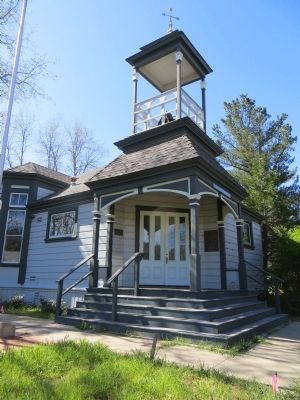
Built at Witch Creek, ten miles west of Julian in 1888 and used thru June 1954. this historical building was moved to Julian in 1970, and restored by the Julian Historical Society, the County of San Diego, and many other donors.
Rededicated 1971
In recognition of the vision, efforts, and generosity of the citizens who have made this project a reality.
San Diego County Board of Supervisors
Jack Walsh 1st District, Henry A. Boney 2nd District, Harry F. Scheidle 3rd District, Jim Bear 4th District, William A. Craven 5th District, DR Graff Austin ex 1945-70, Miles W. Kratka ex 1970, Chief Administrative Officer Fred J. Morly
Topics. This historical marker is listed in this topic list: Education. A significant historical month for this entry is June 1954.
Location. 33° 4.656′ N, 116° 36.164′ W. Marker is in Julian, California, in San Diego County. Marker is on 4th Street, on the right when traveling south. Touch for map. Marker is at or near this postal address: 2133 4th Street, Julian CA 92036, United States of America. Touch for directions.
Other nearby markers. At least 8 other markers are within walking distance of this marker. Julian (a few steps from this marker); Julian Pioneer Museum (within shouting distance of this marker); Honoring Black Pioneers of Julian (within shouting distance of this marker); De Luca Store (about 300 feet away, measured in a direct line); a different marker also named Julian (about 300 feet away); Julian Town Hall (about 300 feet away); Levi~Marks Store (about 400 feet away); Julian / The Eagle Gold Mine (about 400 feet away). Touch for a list and map of all markers in Julian.
Credits. This page was last revised on June 16, 2016. It was originally submitted on April 13, 2015, by Bill Kirchner of Tucson, Arizona. This page has been viewed 465 times since then and 28 times this year. Photos: 1, 2, 3, 4. submitted on April 13, 2015, by Bill Kirchner of Tucson, Arizona. • Andrew Ruppenstein was the editor who published this page.


