Castalian Springs in Sumner County, Tennessee — The American South (East South Central)
Wynnewood
Changing Allegiances
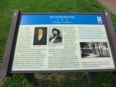
In contrast to many older Southerners who struggled to remain loyal to the Union, their children favored secession. Soon after Abraham Lincoln was elected president in 1860, two of Alfred and Almira Wynne’s sons, Andrew and Joseph Wynne, enlisted in the 2nd Tennessee Infantry under the command of their neighbor, Col. William B. Bate. Their younger sons Valerius and William Hall Wynne also enlisted; William died of disease the next year.
Early in 1862, Confederate cavalry raids designed to interdict Federal supply and communication lines were launched in northern Middle Tennessee. Col. John Hunt Morgan’s command operated in the area and on occasion stopped at Wynnewood to eat. Once, Morgan signed the guest register for one of Wynne’s daughters.
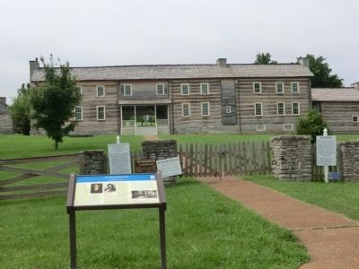
By April, the Union army had set up a military post in the southwestern corner of the Wynne farm and surrounded the fortified camp with log and stone earthworks. Although the Federal troops generally behaved themselves, the harm they did to the trees, fences, and fields was extensive. After the war, Wynne filed a claim for damages in the amount of $6,540, but the U.S. government disallowed it since Wynne had not remained loyal to the Union.
(Side Bar) “With the assistance of one or two near neighbors, in a very short time a good substantial breakfast was prepared which the weary soldiers ate with a good relish. In the meantime a courier was dispatched to Gallatin to find out the strength of the Lincolnites there.”
- Susan Wynne, daughter of Alfred R. Wynne, March 16, 1862.
(Inscription under the photos in the upper left)
Alfred Royal Wynne-Courtesy Allen Haynes. John Hunt Morgan-Courtesy of Allen Haynes.
(Inscription under the photo in the lower right)
Wynnewood ca. 1898-Courtesy Allen Haynes.
Erected by Civil War Trails.
Topics and series. This memorial is listed in these topic lists: Settlements & Settlers • War, US Civil. In addition, it is included in the Tennessee Civil War Trails series list.
Location. 36° 23.683′ N, 86° 18.967′ W. Marker is in Castalian Springs, Tennessee, in Sumner County. Memorial is on Old Highway 25 east of Hartsville Pike, on the right when traveling east. Touch for map. Marker is in this post office area: Castalian Springs TN 37031, United States of America. Touch for directions.
Other nearby markers. At least 8 other markers are within walking distance of this marker. Thomas Sharpe Spencer Memorial (about 500 feet away, measured in a direct line); Bledsoe's Lick (about 500 feet away); William Brimage Bate (approx. 0.2 miles away); Bledsoe's Fort and Monument (approx. 0.2 miles away); A Typical Settler's Cabin (approx. ¼ mile away); Unsettled and Dangerous Years (approx. ¼ mile away); Nathaniel Parker, Hunter and Explorer (approx. ¼ mile away); The Nathaniel Parker Log Cabin (approx. ¼ mile away). Touch for a list and map of all markers in Castalian Springs.
Credits. This page was last revised on June 16, 2016. It was originally submitted on September 7, 2013, by Don Morfe of Baltimore, Maryland. This page has been viewed 627 times since then and 15 times this year. Last updated on May 5, 2015, by J. Makali Bruton of Accra, Ghana. Photos: 1, 2, 3. submitted on September 7, 2013, by Don Morfe of Baltimore, Maryland. • Bernard Fisher was the editor who published this page.


