Armory Park in Tucson in Pima County, Arizona — The American Mountains (Southwest)
Camp Lowell 1866-1873
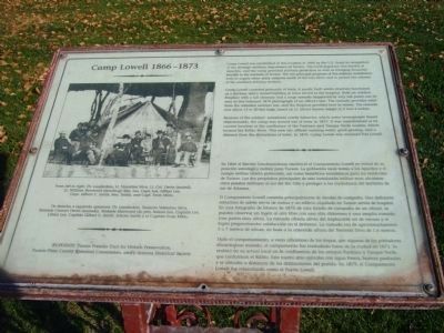
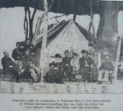
Camp Lowell consisted primarily of tents. A poorly built adobe structure functioned as a kitchen, and a rented building in town served as the hospital. Both an outdoor fireplace with a tall chimney and a large ramada (supported by very tall posts) can be seen in this February 1870 photograph of an officer's tent. The ramada provided relief from the relentless summer sun, and the fireplace provided heat in winter. The ramada was about 15 to 20 feet high, based on Lt. Silva's known height of 5 foot 4 inches.
Because of the soldiers' sometimes rowdy behavior, which some townspeople found objectionable, the camp was moved out of town in 1873. It was reestablished at its current location at the confluence of the Pantano and Tanque Verde washes, which formed the Rillito River. This new site offered running water, good grazing, and a distance from the distractions of town. In 1879, Camp Lowell was renamed Fort Lowell.
Spanish Translation
En 1866 el Ejercito Estadounidense estableció el Campamento Lowell en virtud de su posición estratégica militar para Tucson. La población local temía a los Apaches y el campo militar ofrecía protección, así como beneficios económicos para los residentes de Tucson. Los dos propósitos principales de esta instalación militar eran abastecer otros puestos militares al sur del Río Gila y proteger a los ciudadanos del territorio de sur de Arizona.
El Campamento Lowell consistía principalmente de tiendas de campaña. Una deficiente estructura de adobe servía de cocina y un edificio alquilado in Tucson servía de hospital. En una fotografía de febrero de 1870 de una tienda de campaña de un oficial, se pueden observar un fogón al aire libre con una alta chimenea y una amplia ramada (con postes muy altos). La ramada ofrecía alivio del implacable sol de verano y el fogón proporcionaba calefacción en el invierno. La ramada era de aproximadamente 5 a 7 metros de altura, en base a la conocida altura del Teniente Silva de 1.6 metros.
Dado el comportamiento, a veces alborotoso de las tropas, que algunos de los pobladores encontraban molesto, el campamento fue trasladado fuera de la ciudad en 1873. Se reubicó en su actual local en la confluencia de los arroyos Pantano
y Tanque Verde,
que conforman el Rillito. Este nuevo sitio contaba con agua fresca, buenos pastizales y se ubicaba a distancia de las distracciones del pueblo. En 1879, el Campamento Lowell fue rebautizado como el Fuerte Lowell.
Erected by Tucson Presidio Trust for Historic Preservation, Tucson-Pima County Historical Commission, and/y Arizona Historical Society.
Topics. This historical marker is listed in these topic lists: Forts and Castles • Wars, US Indian. A significant historical month for this entry is February 1870.
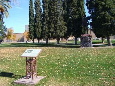
Location. 32° 13.134′ N, 110° 58.108′ W. Marker is in Tucson, Arizona, in Pima County. It is in Armory Park. Marker is on South 6th Avenue, on the right when traveling north. Marker is at the southwest corner of Armory Park. Touch for map. Marker is at or near this postal address: 290 S 6th Ave, Tucson AZ 85701, United States of America. Touch for directions.
Other nearby markers. At least 8 other markers are within walking distance of this marker. Spanish War Veterans Monument (a few steps from this marker); World War I Memorial (within shouting distance of this marker); To The Mormon Battalion (within shouting distance of this marker); Temple of Music and Art (about 500 feet away, measured in a direct line); Scott Avenue (about 700 feet away); Corral Street (about 700 feet away); a different
Photographed By Bill Kirchner, December 12, 2010
3. Camp Lowell 1866-1873 Photo Displayed on Marker
From left to right, Dr. Lauderdale, Lt. Valentine Silva, Lt. Col. Devin (seated), Lt. William Sherwood (standing), Mrs. Lee, Capt. Lee, Lillian Lee, Capt. Gilbert C. Smith, Mrs. Smith, and Capt. Evan Miles.
De derecha a izquierda aparecen: Dr. Lauderdale, Teniente Valentine Silva, Teniente Coronel Devin (sentado), Teniente Sherwood (de pie), Señora Lee, Capitán Lee, Lillian Lee, Capitán Gilbert C. Smith, Señora Smith y el Capitán Evan Miles.
De derecha a izquierda aparecen: Dr. Lauderdale, Teniente Valentine Silva, Teniente Coronel Devin (sentado), Teniente Sherwood (de pie), Señora Lee, Capitán Lee, Lillian Lee, Capitán Gilbert C. Smith, Señora Smith y el Capitán Evan Miles.
Related markers. Click here for a list of markers that are related to this marker.
Credits. This page was last revised on June 16, 2016. It was originally submitted on December 14, 2010, by Bill Kirchner of Tucson, Arizona. This page has been viewed 1,483 times since then and 61 times this year. Last updated on May 6, 2015, by J. Makali Bruton of Accra, Ghana. Photos: 1. submitted on December 18, 2010, by Bill Kirchner of Tucson, Arizona. 2, 3, 4, 5. submitted on December 14, 2010, by Bill Kirchner of Tucson, Arizona. • Bill Pfingsten was the editor who published this page.
