Tuscumbia in Colbert County, Alabama — The American South (East South Central)
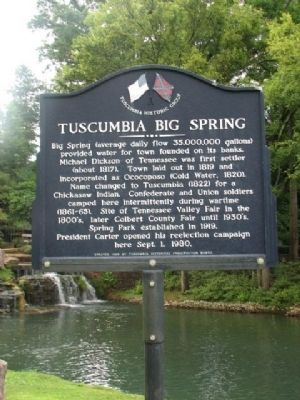
Tuscumbia Big Spring
Erected 1989 by Tennessee Historical Preservation Board.
Topics and series. This historical marker is listed in these topic lists: Native Americans • Settlements & Settlers • War, US Civil • Waterways & Vessels. In addition, it is included in the Former U.S. Presidents: #39 James Earl "Jimmy" Carter, Jr. series list. A significant historical month for this entry is September 1944.
Location. 34° 43.802′ N, 87° 42.225′ W. Marker is in Tuscumbia, Alabama, in Colbert County. Marker is on Spring Park Road, on the left when traveling west. Marker is located at the intersection of S. Main St. and Spring Park Rd. on left upon entering into the park. Touch for map. Marker is in this post office area: Tuscumbia AL 35674, United States of America. Touch for directions.
Other nearby markers. At least 8 other markers are within walking distance of this marker. Petrified Conifer Tree / Petrified Lycopod Tree Stump (within shouting distance of this marker); Cold Water Falls (within shouting distance of this marker); Sacred Tears (about 300 feet away, measured in a direct line); American Indian History (about 400 feet away); Jackson's Military Road (about 400 feet away); History of Tuscumbia, Alabama (about 500 feet away); U. S. Army M60A3 Main Battle Tank (about 500 feet away); Tuscumbia Railway First Railroad west of Alleghenies (approx. 0.2 miles away). Touch for a list and map of all markers in Tuscumbia.
Credits. This page was last revised on February 9, 2020. It was originally submitted on March 13, 2010, by Sandra Hughes Tidwell of Killen, Alabama, USA. This page has been viewed 2,666 times since then and 50 times this year. Last updated on May 19, 2015, by J. Makali Bruton of Accra, Ghana. Photos: 1, 2, 3. submitted on March 13, 2010, by Sandra Hughes Tidwell of Killen, Alabama, USA. • Bill Pfingsten was the editor who published this page.


