Coteau-du-Lac in Vaudreuil-Soulanges, Québec — Central Canada (French-Canadian)
The Coteau-du-Lac rapids
Les rapides de Coteau-du-lac

Photographed By Barry Swackhamer, August 6, 2014
1. The Coteau-du-Lac rapids Marker
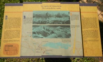
Captions (English / French): (top) This painting, done by John Arthur Roebuck, around 1829, depicts the Coteau-du-Lac rapids seen from Prison Island. It shows the octagonal blockhouse on the point, the south trapezoidal-shaped blockhouse at the far left and various other buildings. / Cette peinture, exécutée par John Arthur Roebuck vers 1820, représente les rapides de Coteau-du-lac vus de l’ile aux prisonnier. On y distingue le blockhaus octagonal sur la pointe, le blockhaus sud a la forme trapezoidal, à l’extreme gauche, ainsi que divers autres bâtiments.; (middle) This photograph, taken by William Notman in 1878, shows the crew of a “batteau” shooting the Lachine rapids. / Photographie par William Notman, cette scène illustre l’equipage d’un «batteau» affrontant les rapides de Lachine, en 1878.: Map of rapides on the St. Lawrence at the bottom.
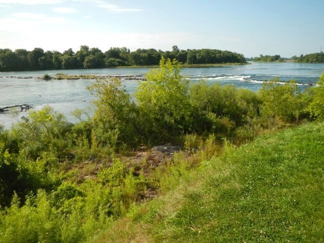
The St. Lawrence River abounded with rapids between Montréal and Kingston, especially in the stretch between Lake Saint-Louis and Lake Saint-François, where a series of “cascades” made navigation impossible. Of all the rapids in this part of the river, those at Coteau-du-Lac were by far the most turbulent. In 1781, M. Pouchot described how this obstacle was crossed in these terms:
“… We punted up the river until we reached Coteau-du-lac… It is a point of land where the water boils and rages so fiercely, that the boats must be unloaded. This portage is sixty paces long. It is necessary to enter the water in order to lift the boat and take it around this point.”
Excerpt from “Mémoires sur la dernière guerre de l’Amérique septentrionale entre la France et l’Angleterre.”
French:
Entre Montréal et Kingston, le fleuve Saint-Laurent était littéralement jalonné de rapides et plus particulièrement entre les lacs Saint-Louis et Saint-François, où une série de «saults» rendaient la navigation impossible. Sur cette section du fleuve, les rapides de Coteau-du-lac s’avéraient sans contredit le plus impétueux. Voici comment M. Pouchot relate la traversée de cet obstacle, en 1781:
«… On monte à la pêche jusques au portage du Coteau-du-lac… c’est une point de terre où l’eau est si agitée, & bouillonne si fort, que l’on y est obligé de décharger les bateaux. Ce portage est de soixante pas. Ils faut se mettre à l’eau, pour monter le bateau & le faire tourner cette point.
Extrait tiré des Mémoires sur la dernière guerre de l’Amérique septentrionale entre la France et l’Angleterre.»
Erected by Parks Canada / Parcs Canada.
Topics. This historical marker is listed in this topic list: Waterways & Vessels. A significant historical year for this entry is 1781.
Location. 45° 17.213′ N, 74° 10.578′ W. Marker is in Coteau-du-Lac, Québec, in Vaudreuil-Soulanges. Marker is on Chemin du Fleuve close to Rue du Fort, on the left when traveling south. Touch for map. Marker is at or near this postal address: 307 Chemin du Fleuve, Coteau-du-Lac QC J0P 1B0, Canada. Touch for directions.
Other nearby markers. At least 8 other markers are within walking distance of this marker. The “rigolet” canal (a few steps from this marker); Why a canal at Coteau-du-Lac? (within shouting distance of this marker); Changes in the landscape (within shouting distance of this marker); The first lock canal in North America (within shouting distance of this marker); The construction of the canal (within shouting distance of this marker); A supply centre / Un poste de ravitaillement

Photographed By Barry Swackhamer, August 6, 2014
2. A Major Obstacle / Un obstacle de taille Plaque
English:
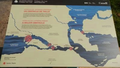
The Coteau-du-Lac rapids, stretching for 12.8 km between Lake St. Louis and Lake St. Francis, are the most turbulent section of the St. Lawrence River. The water drops a total of 25.6 metres over this section, for an average slope of 1.9 metres per kilometre, the steepest anywhere on the St. Lawrence.
French:
Les rapides de Coteau-du-Lac sont les plus impétueux du Saint-Laurent. Ils courent entre les lacs Saint-François et Saint-Louis sur 12,8 kilomètres. On y enregistre une dénivellation totale de 25,6 mètres, soit une dénivellation de 25,6 mètres (sic), soit en moyenne 1,9 mètre par kilomètre, la plus forte.
Click on the image of the marker to enlarge the map.
More about this marker. This marker is located at Coteau-du-Lac National Historic Site.

Photographed By Barry Swackhamer, August 6, 2014
3. Three Ways Around the Rapids / Trois façons de contourner les rapides Plaque
English:
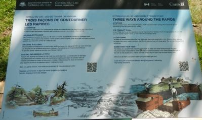
A Portage
For thousands of years, Natives traveling along the St. Lawrence had to portage their canoes for several kilometres to skirt the Coteau-du-Lac ragids
The “Rigolet” Canal
In the 1700s, the French built a shallow channel to protect their “batteaux” from the raging rapids. On your left, you can see the “rigolet” canal - a rock embankment near the shore.
A Lock Canal
To speed up transportation along the river, the British has a lock canal built in 1814. A lock is like and elevator for boats, with stone-walled chambers that fill with water and seal with large gates. You can see the upper lock behind you.
Water Over Your Head!
The Coteau-du-Lac point was originally surrounded by water and water flowed through the canal. The construction of hydroelectric dams and the St. Lawrence Seaway in the 1950s caused the level in the river to drop by about 2.5 metres, however. That is why the point and the canal are dry now.
Were it not for them, you’d be in water over your head right now!
Look for a row of concrete blocks along the ground, indicating the former shoreline.
French:
Un portage
Pendant des millénaires, pour contourner les rapides de Coteau-du-Lac, les autochtones qui empruntaient le Saint-Laurent ont portagé, marchant des kilomètres en portant leur canots à bout des bras.
Un rigolet Français
Les Français on construit au milieu de 18ᵉ siècle un couloir navigable peu profond qui protégeait leurs «batteaux» de la violence des rapides. À votre gauche, voyez le rigolet, canal formé par un digue de pierres parallèle au rives du la point Coteau-du-Lac.
Un canal à écluses
Afin d’accélérer le transport sur le voie fluviale, les Britanniques font creuser en 1814 un canal à écluses. Les écluses sont de véritables ascenseurs à bateaux, formes de sas en maçonnerie fermés par de grandes portes. Observez derrière vous l’écluses d’amont.
De l’eau par-dessus la tête!
Aujourd’hui, la point de Coteau-du-Lac n’est plus entourée d’eau. La construction de barrages hydroélectriques et la création de la voie maritime du Saint-Laurent dans les années 1950 ont entrainé une baisse du niveau du fleuve de 2,5 mètres. Voilà pourquoi les eaux ne traversent plus la pointe du site et ne pénètrent plus à l’intérieur du canal.
Sans ce grands travaux, vous auriez en ce moment de l’eau par-dessus la tête!
Repérez sur la terrain la ligne de blocks de béton qui indique l’ancien emplacement des berges.
Credits. This page was last revised on June 16, 2016. It was originally submitted on May 29, 2015, by Barry Swackhamer of Brentwood, California. This page has been viewed 435 times since then and 40 times this year. Photos: 1, 2, 3, 4. submitted on May 29, 2015, by Barry Swackhamer of Brentwood, California. • Andrew Ruppenstein was the editor who published this page.
