Near Philomont in Loudoun County, Virginia — The American South (Mid-Atlantic)
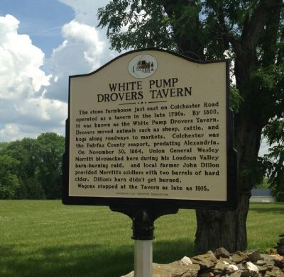
White Pump Drovers Tavern
On November 30, 1864, Union General Wesley Merritt bivouacked here during his Loudoun Valley barn-burning raid, and local farmer John Dillon provided Merritt's soldiers with two barrels of hard cider. Dillon's barn didn't get burned.
Wagons stopped at the Tavern as late as 1915.
Erected by Snickersville Turnpike Association.
Topics. This historical marker is listed in these topic lists: Industry & Commerce • Roads & Vehicles • War, US Civil. A significant historical month for this entry is November 1911.
Location. 39° 4.354′ N, 77° 45.327′ W. Marker is near Philomont, Virginia, in Loudoun County. Marker is at the intersection of Snickersville Turnpike (Virginia Route 734) and Colchester Road (Virginia Route 730), on the right when traveling north on Snickersville Turnpike. Touch for map. Marker is in this post office area: Purcellville VA 20132, United States of America. Touch for directions.
Other nearby markers. At least 8 other markers are within 4 miles of this marker, measured as the crow flies. Bacon Fort (approx. 0.9 miles away); Round Oak Rag Apple Elevation (approx. 1.4 miles away); Battle of Unison (approx. 1.4 miles away); Bushrod Lynn (approx. 2.2 miles away); Hibbs Bridge (approx. 3 miles away); Ebenezer Churches (approx. 3.2 miles away); a different marker also named The Battle of Unison (approx. 3.2 miles away); a different marker also named Battle of Unison (approx. 3.3 miles away). Touch for a list and map of all markers in Philomont.
Also see . . . Snickersville Turnpike Association. (Submitted on June 1, 2015.)
Credits. This page was last revised on June 16, 2016. It was originally submitted on May 31, 2015, by T. Elizabeth Renich of Winchester, Virginia. This page has been viewed 1,237 times since then and 63 times this year. Photo 1. submitted on May 31, 2015, by T. Elizabeth Renich of Winchester, Virginia. • Bernard Fisher was the editor who published this page.
Editor’s want-list for this marker. Wide shot of marker and its surroundings. Photo of the stone farmhouse. • Can you help?
