Maysville in Mason County, Kentucky — The American South (East South Central)
Limestone Landing
— 1780's —
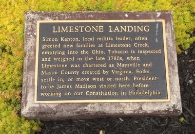
Simon Kenton, local militia leader, often greeted new families at Limestone Creek, emptying into the Ohio. Tobacco is inspected and weighed in the late 1780s, when Limestone is chartered as Maysville and Mason County created by Virginia. Folks settle in, or move west or north. President-to-be James Madison visited here before working on our Constitution in Philadelphia.
Erected 1998 by Maysville-Mason County Area Chamber of Commerce, Limestone Economic Development, Inc.
Topics and series. This historical marker is listed in these topic lists: Agriculture • Settlements & Settlers • Waterways & Vessels. In addition, it is included in the Former U.S. Presidents: #04 James Madison series list.
Location. 38° 38.872′ N, 83° 45.736′ W. Marker is in Maysville, Kentucky, in Mason County. Marker can be reached from the intersection of East McDonald Parkway and Limestone Street. Touch for map. Marker is at or near this postal address: 25 East McDonald Parkway, Maysville KY 41056, United States of America. Touch for directions.
Other nearby markers. At least 8 other markers are within walking distance of this marker. La Fayette's Visit to Maysville (here, next to this marker); Front Street Maysville, 1850 (a few steps from this marker); Buffalo Trace (a few steps from this marker); Underground Rail Road (within shouting distance of this marker); Maysville Shipbuilding / "Maysville's" Voyaging (within shouting distance of this marker); Lewis and Clark in Kentucky / John Colter (ca. 1775-1813) (within shouting distance of this marker); Maysville River Front 1900 (within shouting distance of this marker); Mason County Spy Company (within shouting distance of this marker). Touch for a list and map of all markers in Maysville.
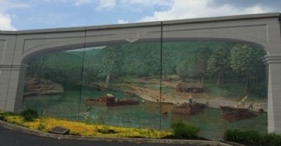
Regarding Limestone Landing. Spring time in the late 18th century shows the limestone shelf which gave the place its early name, ‘Limestone Landing’. While the formation provided a good place to dock, few settlers remained on the river bank.
There were limited opportunities for farming at Limestone, and the vulnerability to Indian attacks from across the river.
After landing, most settlers migrated southward using the Buffalo Trace or Limestone Creek into safer locations.
Generally the first stop was Washington. It was a full days journey from Limestone Landing for freight using draft animals.
Keel boats and flat boats that were used for river traveling were often dismantled and transported south where they were rebuilt into housing. One such structure, Mefford’s Fort still exists in Old Washington, section of Maysville.
Credits. This page was last revised on June 16, 2016. It was originally submitted on June 1, 2015, by Mark Hilton of Montgomery, Alabama. This page has been viewed 834 times since then and 105 times this year. Photos: 1, 2, 3. submitted on June 1, 2015, by Mark Hilton of Montgomery, Alabama.


