San Salvador, El Salvador — Central America (West Coast)
Construction of the North-South Highway and the Central American University
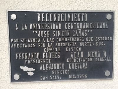
Inscription.
a la Universidad Centroamericana
“Jose Simeon Cañas”
por su ayuda a las comunidades que estaban
afectadas por la autopista norte-sur.
Comite civico
Fernando Flores Presidente
Adan Mena M. Coordinador General
Alejandro Guevara Sindico
San Salv. Dic. 1988
to the Central American University
“Jose Simeon Cañas”
for their help to communities
affected by the north-south highway construction.
Civic committee
Fernando Flores, President
Adan Mena M., General Coordinator
Alejandro Guevara, Representative
San Salvador, December 1988
Erected 1988.
Topics. This historical marker is listed in these topic lists: Bridges & Viaducts • Roads & Vehicles. A significant historical year for this entry is 1988.
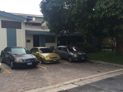
Location. 13° 40.744′ N, 89° 14.227′ W. Marker is in San Salvador. This marker is on the front of the Publications Building on the campus of the Universidad Centroamericana (UCA). Touch for map. Touch for directions.
Other nearby markers. At least 8 other markers are within walking distance of this marker. Francisco Andrés Escobar Building (a few steps from this marker); Dr. Ignacio Martín-Baró (within shouting distance of this marker); Mural of the Martyrs of the UCA (within shouting distance of this marker); The Francisco Javier Ibisate Building (about 120 meters away, measured in a direct line); Students Peace Plaza (about 120 meters away); Massacre at the Central American University (UCA) (about 150 meters away); Elba and Celina Ramos Auditorium (about 180 meters away); Florentino Idoate (about 180 meters away). Touch for a list and map of all markers in San Salvador.
Regarding Construction of the North-South Highway and the Central American University. After the construction of the new airport near San Luis Talpa in the 1980s, the Salvadoran government began construction on a new highway to connect the airport with the capital. This North-South highway passed directly through many small communities that the University of Central America supported during the legal negotiations related to the highway construction.
Credits. This page was last revised on May 17, 2021. It was originally submitted on June 11, 2015, by J. Makali Bruton of Accra, Ghana. This page has been viewed 397 times since then and 14 times this year. Photos: 1, 2. submitted on June 11, 2015, by J. Makali Bruton of Accra, Ghana. • Andrew Ruppenstein was the editor who published this page.

