Cankurtaran in İstanbul in Fatih, Turkey — West Asia or Southeast Europe
Gulhane Park
Gülhane Parkı
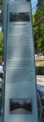
Gulhane Park used to be the exterior yard of Topkapi Palace during the Ottoman Period, encompassing rose gardens and a grove.
Gulhane was landscaped and transformed into a park in 1912 during the period of Cemil Topuzlu, former Mayor of Istanbul, and became public. Its total area is around 163 decares. On the right side of the entrance lie the busts of former mayors. A path of trees on both sides passes through the center of the park. Right and left to this path, there are some resting places and a playground. On right side of the slope curling through the Bosphorus, there is the sculpture of Asık Veysel and a little above at the end of the slope lies the Column of the Goths from the Romans.
Sarayburnu Park used to be in the main park connected by a bridge over Sirkeci railway line. The park was later separated from Gulhane with the coastal road (1958).
The park was restorated (sic) by Istanbul Metropolitan Municipality in 2003. The Imperial Edict of Reorganization, which is the first concrete step of democratization in Turkish history, was declared by the Minister of Foreign Affairs Mustafa Resit Pasha on 3 November 1839 during the period of Abdulmecid, in the Gulhane Park and therefore it is also known as ”Gulhane Hatt-ı Humayun”
Erected by Istanbul Büyükşehir Belediyesi (Istanbul Metropolitan Municipality).
Topics. This historical marker is listed in this topic list: Natural Features. A significant historical date for this entry is November 3, 1839.
Location. 41° 0.656′ N, 28° 58.738′ E. Marker is in İstanbul, in Fatih. It is in Cankurtaran. Marker can be reached from Alemdar Caddesi close to Soǧuk Çeşme Sokak, on the left when traveling south. Touch for map. Marker is at or near this postal address: Alemdar Cd 30, İstanbul 34122, Turkey. Touch for directions.
Other nearby markers. At least 8 other markers are within walking distance of this marker. Alay Pavillion (within shouting distance of this marker); Pasakapisi (within shouting distance of this marker); The Remnants of the Theodosian Hagia Sophia (5th Century) (about 210 meters away, measured in a direct line); Hagia Sophia (approx. 0.2 kilometers away); Basilica Cistern (approx. 0.3 kilometers away); a different marker also named The Basilica Cistern (approx. 0.3 kilometers away); The Türbe (Tomb) of Sultan Selim II (approx. 0.3 kilometers away); Million (approx. 0.3 kilometers away). Touch for a list and map of all markers in İstanbul.
Credits. This page was last revised on February 13, 2023. It was originally submitted on July 5, 2015, by Barry Swackhamer of Brentwood, California. This page has been viewed 332 times since then and 13 times this year. Photos: 1, 2. submitted on July 5, 2015, by Barry Swackhamer of Brentwood, California. • Andrew Ruppenstein was the editor who published this page.

