Leaders, Stewards and Advocates
1873-1913
— East State Street —
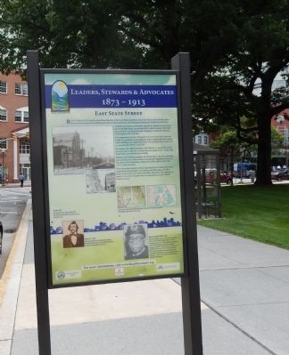
To shelter the diverse community, a grand new church was constructed on East State Street, current site of the Capitol Fountain. The building committee included Ephraim Slaughter, an African American who fought in the Civil War.
On inauguration Sunday, folks gathered from across the Commonwealth to participate in honoring the achievement. Only the Sunday school building was completed in time. Four services were conducted to accommodate all who convened.
By evening, the collection plates held $500.00, a major achievement at a time when tradesmen and day laborers made $1.50-$3.00 a day. Small coins accomplished great things.
However, the building committee was $9,000 short. This was a daunting sum until members John Polston and Ephraim Slaughter borrowed the money from Dickinson College of Carlisle. Still, it took until 1893 to retire the debt.
From the pulpit and pews of the East State Street building flowed an outpouring of leadership, stewardship and fellowship, as well as fierce advocacy for civil rights and public education. The church was indeed a fountain of support for its congregation
and the Old 8th Ward it served.
(Inscription below the images at the bottom, left to right, top to bottom)
*Above and right. Bethel AME on State Street, Harrisburg.
*Above Left: Location of the Bethel AME Church, State Street, Harrisburg map, 1800. Above Right: Same location, current map.
*February 19, 1878 William Howard Day is elected to the Harrisburg School Board of Directors, the first African American to hold an elected position in the city.
*Ephraim Slaughter (1846-1943) Ephraim Slaughter was born a slave in North Carolina where he lived until his escape in 1863. He joined Company B of the 3rd N.C. Colored Infantry, also known as the 37th United States Colored Troops regiment. Slaughter moved to Harrisburg after the Civil War and married his wife Carrie in 1880. A member of Bethel AME, he joined the African-American Grand Army of the Republic, David Stevens Post 834. Slaughter died on February 176, 1943 and is buried in Lincoln Cemetery in Pembrook, Pennsylvania.
Erected by Dauphin County.
Topics and series. This historical marker is listed in these topic lists: African Americans • Churches & Religion • Civil Rights. In addition, it is included in the African Methodist Episcopal (AME) Church series list. A significant historical month for this entry is February 1873.
Location. 40° 15.805′
Other nearby markers. At least 8 other markers are within walking distance of this marker. Trailblazers (here, next to this marker); Technical High School & Old City Hall (a few steps from this marker); Underground Railroad (a few steps from this marker); A Bench by the Road: Old Eighth Ward of Harrisburg (within shouting distance of this marker); Original Capitol Complex (within shouting distance of this marker); a different marker also named Underground Railroad (within shouting distance of this marker); Walnut Place (within shouting distance of this marker); Pennsylvania Canal (about 400 feet away, measured in a direct line). Touch for a list and map of all markers in Harrisburg.
Credits. This page was last revised on June 16, 2016. It was originally submitted on July 22, 2015, by Don Morfe of Baltimore, Maryland. This page has been viewed 307 times since then and 10 times this year. Photos: 1, 2. submitted on July 22, 2015, by Don Morfe of Baltimore, Maryland. • Bill Pfingsten was the editor who published this page.

