Maidens in Goochland County, Virginia — The American South (Mid-Atlantic)
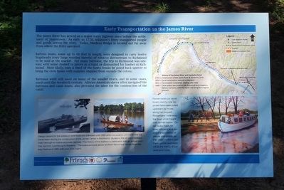
Early Transportation on the James River
Batteau boats, some up to 60 feet in length, were designed to carry twelve hogsheads (very large wooden barrels) of tobacco downstream to Richmond to be sold at the market. For many batteaux, the trip to Richmond was one-way; with some dashed to pieces in a rapid or dismantled for lumber in Richmond. Most likely, only a third of the boats would be poled back upriver to bring the crew home with supplies shipped from outside the colony.
Batteaux were still used on many of the smaller rivers, and in some cases, used until the twentieth century. African-American slaves often navigated the bateaux and canal boats, also provided the labor for the construction of the canal.
Erected by Friends of Goochland Parks.
Topics. This historical marker is listed in these topic lists: Industry & Commerce • Waterways & Vessels. A significant historical year for this entry is 1728.
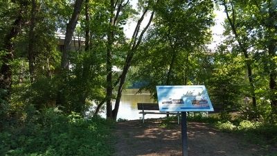
Location. 37° 39.955′ N, 77° 53.271′ W. Marker is in Maidens, Virginia, in Goochland County. Marker can be reached from Maidens Loop west of Maidens Road (U.S. 522), on the left when traveling west. Located in Tucker Park at Maidens Crossing. Touch for map. Marker is in this post office area: Maidens VA 23102, United States of America. Touch for directions.
Other nearby markers. At least 8 other markers are within 2 miles of this marker, measured as the crow flies. Maidens Adventure Hotel (about 300 feet away, measured in a direct line); Maidens, Virginia (approx. ľ mile away); Michaux Grant (approx. 0.7 miles away); Brightly (approx. ĺ mile away); Goochland Courthouse (approx. 1.1 miles away); Goochland County Courthouse (approx. 1.2 miles away); Goochland's Jail (approx. 1.2 miles away); Goochland's Courthouse Square (approx. 1.2 miles away). Touch for a list and map of all markers in Maidens.
Also see . . . Tucker Park at Maidens Crossing. Goochland County (Submitted on August 8, 2015.)
August 8, 2015
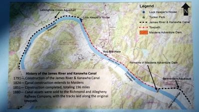
2. History of the James River and Kanawha Canal
1791-Construction of the James River & Kanawha Canal
1824-Canal construction extends to Maidens
1851-Construction completed, totaling 196 miles
1880-Canal assets were sold to the Richmond and Allegheny Railway Company, with the tracks laid along the original towpath.
1824-Canal construction extends to Maidens
1851-Construction completed, totaling 196 miles
1880-Canal assets were sold to the Richmond and Allegheny Railway Company, with the tracks laid along the original towpath.
August 8, 2015
3. Early Transportation on the James River Marker
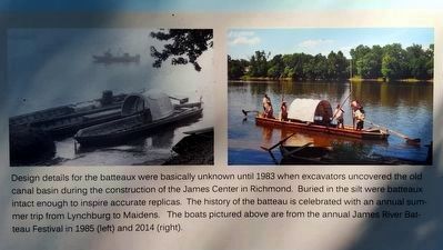
Design details for the batteaux were basically unknown until 1983 when excavators uncovered the old canal basin during the construction of the James Center in Richmond. Buried in the silt were batteaux intact enough to inspire accurate replicas. The history of the batteau is celebrated with an annual summer trip from Lynchburg to Maidens. The boats pictured above are from the annual James River Batteaux Festival in 1985 (left) and 2014 (right).
August 8, 2015
4. Early Transportation on the James River Marker
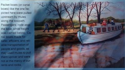
Packet boats (or canal boats) like the one depicted here were pulled upstream by mules along the towpath. Passengers rode atop the boat, while freight was carried below. Canal boats made for safer, efficient, and reliable transportation of people and goods, as they used mules to pull the upriver and were not at the mercy of currents and rocks. pulled
Credits. This page was last revised on November 5, 2021. It was originally submitted on August 8, 2015, by Bernard Fisher of Richmond, Virginia. This page has been viewed 921 times since then and 90 times this year. Photos: 1. submitted on August 8, 2015, by Bernard Fisher of Richmond, Virginia. 2, 3. submitted on August 8, 2015. 4, 5. submitted on August 8, 2015, by Bernard Fisher of Richmond, Virginia.
