Belfield in Stark County, North Dakota — The American Midwest (Upper Plains)
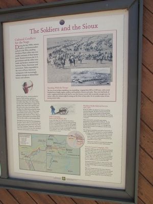
The Soldiers and the Sioux
Cultural Conflicts Set the Stage
During the late 1880s, miners, traders, and homesteaders rushed to the West, pushing Northern Plains tribes into ever smaller remnants of their homelands. Treaties between the U.S. government and the tribes were made and broken; tensions rose between Native Americans and newcomers. Tribes responded to the wave of Euro-American immigrants with increasingly militant attempts to defend their homes and cultures.
For the Santee Sioux, tensions peaked in August of 1862 and their uprising in Minnesota Territory left 450-800 settlers and soldiers dead. Brig. Gen. Henry Sibley was sent with 1,400 soldiers to suppress the uprising. Many Santee were captured; some fled west to join other Sioux bands. Sibley and Brig. Gen. Alfred Sully pursued the Santee into Dakota Territory where Sibley fought several battles in July and August 1863. In September, Sully’s attack on a Sioux village at Whitestone Hill resulted in more Indian deaths than any other conflict on the Northern Plains.
Throughout Custer Trail Auto interpretation, the name “Sioux” refers to several bands who fought together during the Great Sioux War, including Hunkpapa, Yanktonai, and Santee. They were joined at times by a few Northern Cheyenne and members of other tribes.
Sully’s Campaign
Battle of the Badlands, 1864
In June 1864, Brig. Gen. Sully led the first military expedition into the badlands, intent on further punishing the Sioux and establishing new military posts. Sully engaged the Sioux at Killdeer Mountain on July 28. Ten days later, the Sioux surprised the column coming through a narrow gorge, beginning the three-day running battle – the Battle of the Badlands – that ended at Square Butte with the Sioux in retreat.
Northern Pacific Railroad Surveys, 1871-1873
By the late 1860s, the railroad was intent on pushing west from Bismarck. The Sioux, having witnessed the decimation of bison herds brought by railroads farther south, were equally determined to stop them. The resulting tension made military protection of railroad survey parties a necessity.
Three survey parties, escorted by large military detachments, crossed the Dakota badlands. The first Northern Pacific Railroad survey was accompanied by Major Joseph Whistler in 1871. It is thought they followed Davis Creek to its confluence with the Little Missouri River.
Two subsequent expeditions were led by Colonel David Stanley. The 1872 party attempted to avoid the badlands by taking a more southerly route, but they returned via Whistler’s route. Convinced this route was the easiest, Stanley’s column of almost 2,000 men, 275 wagons, and a cattle herd retraced the trail along Davis Creek in 1873.
These survey expeditions witnessed a few skirmishes with the Sioux, but no major confrontations.
Terry & Custer’s Campaign, 1876
Ignoring an 1868 treaty, the U.S. government attempted to get the Lakota Sioux to cede the Black Hills(South Dakota) to gold seekers who were pouring into the area. When the Sioux disregarded the government’s order to report to their Indian agencies or be considered “hostile” Brig. Gen. Alfred H. Terry, accompanied by Lt. Col. George A. Custer’s 7th Cavalry, headed west from Ft. Abraham Lincoln to enforce the edict.
Entering the badlands on May 27, 1876, near Easy Hill, Terry’s command continued west into Montana toward the Battle of Little Bighorn where Custer and most of his men died.
Brig. Gen. George Crook was also sent to Montana that summer in pursuit of the Lakota Sioux who refused to go to the reservation. From there, his unit traveled east through the North Dakota badlands, then to South Dakota where they engaged the Sioux in the Battle of Slim Buttes.
Traveling With the Troops
The size of each of these expeditions was astounding – ranging from 600 to 2,200 men, with several hundred heavy freight wagons, artillery, and hundreds of horses and mules. They even had herds of cattle – supplemental food on the hoof in case their hunters weren’t
able to provide enough meat. In narrow valleys the column might be strung out for three to four miles. It’s no wonder traces of their passing remain today.
Topics. This historical marker is listed in this topic list: Wars, US Indian. A significant historical month for this entry is May 1931.
Location. 46° 53.728′ N, 103° 22.893′ W. Marker is in Belfield, North Dakota, in Stark County. Marker is on Interstate 94, on the right when traveling west. Marker is located on the Painted Canyon Visitor Center in Theodore Roosevelt National Park. Touch for map. Marker is in this post office area: Belfield ND 58622, United States of America. Touch for directions.
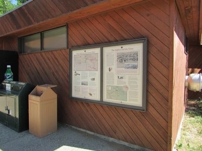
Other nearby markers. At least 8 other markers are within 7 miles of this marker, measured as the crow flies. Time Travel on the Custer Trail (here, next to this marker); The Badlands (within shouting distance of this marker); Welcome to Painted Canyon – A View into Theodore Roosevelt National Park (within shouting distance of this marker); Dude on the Frontier (about 300 feet away, measured in a direct line); Invasion Confronted (about 300 feet away); Invader on the Badlands (about 300 feet away); North Dakota Badlands (approx. 5.9 miles away); Von Hoffman House (approx. 6.8 miles away). Touch for a list and map of all markers in Belfield.
More about this marker. Two photographs of the 1874 Black Hills Expedition appear at the upper right of the marker. The bottom of the marker contains a map of Military Expeditions into the Badlands.
Credits. This page was last revised on June 16, 2016. It was originally submitted on August 15, 2015, by Bill Coughlin of Woodland Park, New Jersey. This page has been viewed 441 times since then and 19 times this year. Photos: 1, 2, 3. submitted on August 15, 2015, by Bill Coughlin of Woodland Park, New Jersey.


