Chester in Chesterfield County, Virginia — The American South (Mid-Atlantic)
Dutch Gap
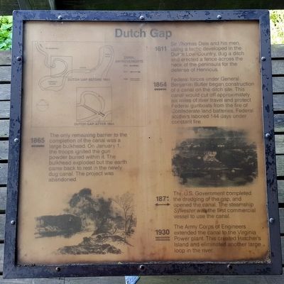
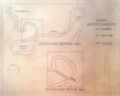
1864 Federal forces under General Benjamin Butler began construction of a canal on the ditch site. This canal would cut off approximately six miles of river travel and protect Federal gunboats from the fire of Confederate land batteries. Federal soldiers labored 144 days under constant fire.
1865 The only remaining barrier to the completion of the canal was a large bulkhead. On January 1, the troops ignited the gun powder buried within it. The bulkhead exploded but the earth came back to rest in the newly dug canal. The project was abandoned.
1871 The U.S. Government completed the dredging of the gap, and opened the canal. The steamship
1930 The Army Corps of Engineers extended the canal to the Virginia Power plant. This created Hatcher’s Island and eliminated another large loop in the river.
Topics. This historical marker is listed in these topic lists: Man-Made Features • Settlements & Settlers • War, US Civil • Waterways & Vessels. A significant historical year for this entry is 1611.
Location. 37° 22.598′ N, 77° 21.63′ W. Marker is in Chester, Virginia, in Chesterfield County. Marker can be reached from Henricus Park Road, 1.3 miles east of Coxendale Road. Located in Henricus Historical Park 300 yards north of the parking lot. Touch for map. Marker is at or near this postal address: 251 Henricus Park Road, Chester VA 23836, United States of America. Touch for directions.
Other nearby markers. At least 8 other markers are within walking distance of this marker. The James River...Floating Through The Centuries (here, next to this marker); The Tides (here, next to this marker); Mount Malady (here, next to this marker); USCTs At Dutch Gap (a few steps from this marker); Dutch Gap Canal (a few steps from this marker); The Bermuda Hundred Campaign (a few steps from this marker); The Lightkeeper’s House (within shouting distance of this marker); Henricopolis (within shouting distance of this marker). Touch for a list and map of all markers in Chester.
Also see . . . Henricus Historical Park. (Submitted on August 30, 2015.)
Credits. This page was last revised on June 16, 2016. It was originally submitted on August 30, 2015, by Bernard Fisher of Richmond, Virginia. This page has been viewed 464 times since then and 20 times this year. Photos: 1, 2, 3. submitted on August 30, 2015, by Bernard Fisher of Richmond, Virginia.


