Spring Arbor in Jackson County, Michigan — The American Midwest (Great Lakes)
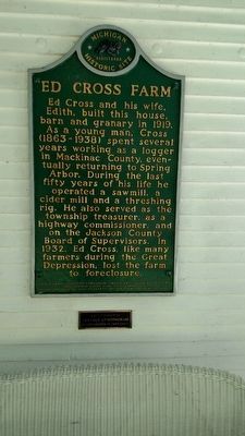
Ed Cross Farm
Erected 2001. (Marker Number l2099.)
Topics and series. This historical marker is listed in this topic list: Agriculture. In addition, it is included in the Michigan Historical Commission series list. A significant historical year for this entry is 1919.
Location. 42° 11.922′ N, 84° 33.218′ W. Marker is in Spring Arbor, Michigan, in Jackson County. Marker is on Teft Rd, on the left when traveling south. This Historical marker is locate on the front porch of the farm house. Difficult to see from the road. Touch for map. Marker is at or near this postal address: 321 Teft Road, Spring Arbor MI 49283, United States of America. Touch for directions.
Other nearby markers. At least 8 other markers are within walking distance of this marker. Max Videto, Sr. (approx. 0.4 miles away); Michigan Central College Residence Hall (approx. 0.4 miles away); Veterans Memorial (approx. 0.4 miles away); Spring Arbor World Wars and Korean War Memorial (approx. 0.4 miles away); Spring Arbor Veterans Memorial (approx. 0.4 miles away); E.P. Hart Circle (approx. half a mile away); The Spring Arbor Campus (approx. half a mile away); Spring Arbor College (approx. half a mile away). Touch for a list and map of all markers in Spring Arbor.
Additional keywords. Farming
Credits. This page was last revised on June 16, 2016. It was originally submitted on September 15, 2015, by Rae Pierce of Rives Junction, Michigan. This page has been viewed 354 times since then and 20 times this year. Photos: 1, 2. submitted on September 15, 2015, by Rae Pierce of Rives Junction, Michigan. • Bill Pfingsten was the editor who published this page.

