Canton in St. Lawrence County, New York — The American Northeast (Mid-Atlantic)
The Natural Environment
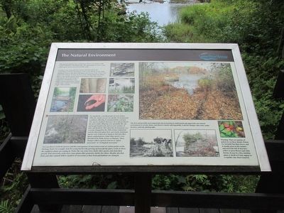
Geology is one of the physical sciences that investigate the composition, structure and history of the earth. Botany is one of the biological sciences that deal with plants and zoology is the science that deals with animals. Ecology focuses on the relationship living things have to one another and to their environment. Other life sciences concentrate on certain kinds of organisms. Ornithology is the study of birds and marine biology is the study of plants and animals in our water systems.
For hundreds, even thousands of years before 1800, the island you are on and the environmental conditions affecting it remained fairly constant. The species of plants that grew best and produced the most viable offspring were probably the oak and maple hardwoods and several varieties of pine and hemlock. But when the environment was severely changed by the 19th century industrial activity that took place here, previously dominant species were removed or began to fail and other species gained power. Some alien species were introduced by birds, horses, or humans. These changes reflect a process known as "plant succession" or "Ecological succession."
You can observe both the process and the consequences of succession events at various points on the Heritage Trail. For example, look for young hardwoods growing up beneath the pines. Look at where the raspberry plants are coming in. Notice the way some trees shade other species and stunt their growth. And conversely, notice how some plants offer protective shelter for others. Realize also that birds and other animals follow a pettern of succession as their food and habitats are changed.
The first and probably most important step to learning to understand and appreciate our natural environment is to look, listen, and observe closely and repeatedly. Look for change, take notes, make sketches, and take photographs.
Warning: There are patches of poison ivy on these islands. Poison ivy normally has three leaves, and is usually green in the summer, and red in the fall. It may have yellow or green flowers and white berries. It may be a free-standing plant or shrub or it may appear as a ropelike vine. Don't touch it!
Erected by Grasse River Heritage.
Topics. This historical marker is listed in this topic list: Environment. A significant historical year for this entry is 1800.
Location. 44° 35.813′ N, 75° 10.527′ W. Marker is in Canton, New York, in St. Lawrence County. Marker can be reached from West Main Street (U.S. 11) 0.2 miles east of Gouverneur Street (New York State Route 68). Marker is on the Heritage Trail in Heritage Park. The park is on the north side of US 11, between the US 11 bridges over the Grasse River. Touch for map. Marker is in this post office area: Canton NY 13617, United States of America. Touch for directions.
Other nearby markers. At least 8 other markers are within walking distance of this marker. Floods, Fires, and Pollution (here, next to this marker); Logging and Lumbering (within shouting distance of this marker); The Sash and Blind Factory (within shouting distance of this marker); The East Channel of the Grasse River (about 300 feet away, measured in a direct line); The Grist Mill (about 300 feet away); The West Channel of the Grasse River (about 300 feet away); Water Street and the Third Dam (about 400 feet away); Canton's Islands / Falls Island in 1898 (about 500 feet away). Touch for a list and map of all markers in Canton.
Credits. This page was last revised on June 16, 2016. It was originally submitted on September 18, 2015, by Anton Schwarzmueller of Wilson, New York. This page has been viewed 276 times since then and 6 times this year. Photos: 1, 2. submitted on September 18, 2015, by Anton Schwarzmueller of Wilson, New York.

