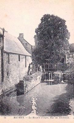
Bayeux in Calvados, Normandy, France — Western Europe
L'Aure
River Aure
— Bayeux, la Qualité a ses Racines —
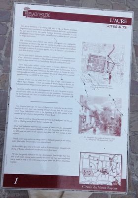
Lors de sa fondation, il y a deux mille ans, la ville de Bayeux (l’antique Augustodurum) s’est étendue sur la rive occidentale de l’Aure, qui la traverse du sud vers le nord. Un grand nombre d’activités artisanales se sont développées depuis l’époque gallo-romaine jusqu’au début du XXe siècle sur les berges de la rivière.
Elle constituait tout d’abord une réserve alimentaire non négligeable, notamment au Moyen Age avec des variétés de poissons plus importantes qu’aujourd’hui. Une partie de la rivière en amont des vannes était d’ailleurs aménagée en réserve de poissons appelée « vivier de l’évêque », car ce dernier y avait droit de pêche exclusif.
Sur les rives étaient également installes les artisans grands consommateurs d’eau: teinturiers, tanneurs ou blanchisseuses, comme en témoigne le lavoir que l’on peut encore voir sur l’autre berge depuis le parking d’Ornano.
L’eau était enfin utilisée comme source d’énergie, différents moulins exploitant la force hydraulique : moulin à grain pour la fabrication de la farine, moulin à tan pour l’obtention du tanin extrait de l’écorce de chêne indispensable au travail du cuir, ou moulin à huile de colza, produit essentiel pour l’éclairage aux XVIIIe et XIXe siècles.
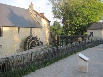
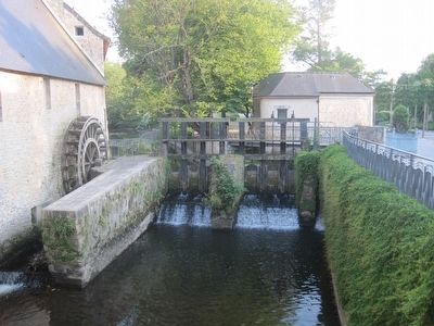
Certains d’entre eux, tel celui du Coisel face à vous, appartenaient au Moyen Age à l’évêque. C’était une source de revenus pour ce dernier, les habitants devant obligatoirement payer une redevance pour cette utilisation.
La rivière a enfin orienté le développement de la cite. Des ponts en pierre ont été ainsi édifiés sur les principaux axes de circulation, notamment ici, rue de Nesmond, où l’Aure est canalisée dès le XIIIe siècle pour passer sous l’ancien hôtel-Dieu.
Two thousand years ago, the town of Bayeux was established on the western bank of the river Aure, now running through the city from the south to the north. From Gallo-Roman times to the beginning of the 20th century, a vast number of craft industries have grown up along its banks.
First, there was fishing. Part of the river, upstream of the lock gates, was thus set aside as a fishing reserve for the Bishop's exclusive use.
Those craft industries requiring vast amounts of water were also concentrated along the banks: dyers, tanners, laundries. The wash-house that can be seen from the d'Ornano car park, on the opposite river bank, still bears witness to these activities.
Finally, water was used as an energy source as hydraulic power fro the various mills: flour mills, tanning mills or even colza oil mills.
In the Middle Ages, some of the mills, such as the one facing us, belonged to the Bishop of Bayeux who derived considerable income from them.
The river has greatly influenced the city's development. Stone bridges have been built at the main crossing points, notably here where the Aure was transformed into a canal as early as the 13th century to pass under the former Hôtel-Dieu hospital.
Erected by La ville de Bayeux. (Marker Number 1.)
Topics and series. This historical marker is listed in these topic lists: Industry & Commerce • Settlements & Settlers • Waterways & Vessels. In addition, it is included in the France - Bayeux - Circuit du Vieux Bayeux series list.
Location. 49° 16.446′ N, 0° 42.068′ W. Marker is in Bayeux, Normandie (Normandy), in Calvados. Marker is on Rue de Nesmond just west of Allée des Augustines, on the left when traveling west. Touch for map. Marker is at or near this postal address: 38 Rue de Nesmond, Bayeux, Normandie 14400, France. Touch for directions.
Other nearby markers. At least 8 other markers are within walking distance of this marker. L'Ancien Seminaire (within shouting distance of this marker); Autour des Augustines (about 150 meters away, measured in a direct line); Le Rempart Gallo-Roman (about 150 meters away); Un édifice du Xe siècle (about 180 meters away); Les Abords du Chevet de la Cathédrale (about 180 meters away); 50th Northumbrian Division Memorial (about 210 meters away); Le palais Episcopal (about 240 meters away); Le Doyen du Chapitre (about 240 meters away). Touch for a list and map of all markers in Bayeux.
More about this marker. The caption on the marker's top photograph reads:
Bayeux à la fin du XVIIIe siècle.
Bayeux at the end of the 18th century.
The caption on the marker's bottom photograph reads:
A. F. Maugendre "Le moulin de l’hôpital", 1863
A. F. Maugendre, "The hospital mill", 1863
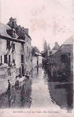
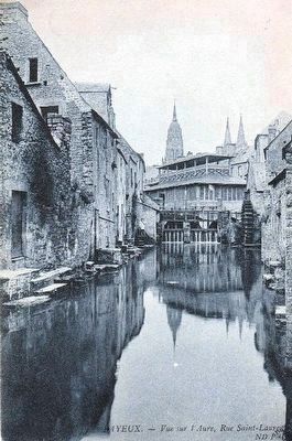
Postcard by ND Phot., circa 1910
5. Bayeaux - Vue sur l'Aure, Rue Saint-Jean
View on the Aure, taken from the bridge on Rue Saint-Jean, about 1-2 blocks north of the marker location. Note on the left of the picture there are 3 women washing laundry, and perhaps more peculiarly, standing atop barrels in the river to do so. (Click to enlarge image.)
Credits. This page was last revised on September 10, 2018. It was originally submitted on September 23, 2015, by Kevin W. of Stafford, Virginia. This page has been viewed 297 times since then and 3 times this year. Photos: 1, 2, 3. submitted on September 23, 2015, by Kevin W. of Stafford, Virginia. 4, 5, 6. submitted on September 24, 2015. • Andrew Ruppenstein was the editor who published this page.
