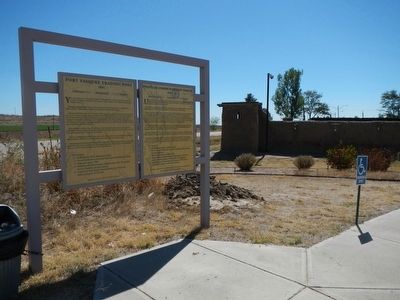
Near Platteville in Weld County, Colorado — The American Mountains (Southwest)
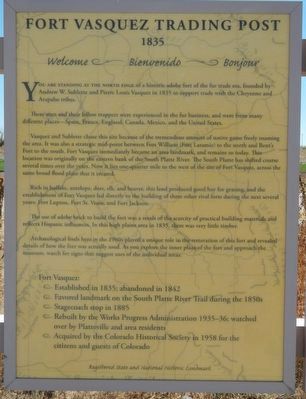
Fort Vasquez Trading Post
1835
— Welcome - Bienvenido - Bonjour —
These men and their fellow trappers were experienced in the fur business, and were from many different places--—-Spain, France, England, Canada, Mexico, and the United States.
Vasquez and Sublette chose this site because of the tremendous amount of native game freely roaming the area. It was also a strategic mid-point between Fort William (Fort Laramie) to the north and Bent’s Fort to the south. Fort Vasquez immediately became an area landmark, and remains so today. This location was originally on the eastern bank of the South Platte River. The South Platte has shifted course several times over the years. Now it lies one-quarter mile to the west of the site of Fort Vasquez, across the same broad flood plain that it created.
Rich in buffalo, antelope, deer, elk, and beaver, this land produced good hay for grazing, and the establishment of Fort Vasquez led directly to the building of three other rival forts during the next several years: Fort Lupton, Fort St. Vrain, and Fort Jackson.
The use of adobe brick to build the fort was a result of the scarcity of practical building materials and reflects Hispanic influences. In this high plains area in 1835, there was very little timber.
Archaeological finds here in the 1960s played a unique role in the restoration of this fort and revealed details of how the fort was actually used. As you explore the inner plaza of the fort and approach the museum watch for signs that suggest uses of the individual areas.
Fort Vasquez:
• Established in 1835; abandoned in 1842
• Favored landmark on the South Platte River Trail during the 1850s
• Stagecoach stop in 1885
• Rebuilt by the Works Progress Administration 1935-36; watched over by Platteville and are residents
• Acquired by the Colorado Historical Society in 1958 for the citizens and guests of Colorado
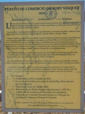
Spanish
1835
Bienvenido - Welcome - Bonjour
Usted se encuentra de pie en la parte norte del fuerte histórico de la época de comercio de pieles fundada por Andrew W. Sublette y Pierre Louis Vásquez en 1835 para sostener comercio entre las naciones Cheyenne y Arapaho.
Estos hombres y sus compañeros eran experimentados en el comercio de pieles y venían de varios lugares del mundo como España, Francia, Inglaterra, Canadá, México y Estados Unidos.
Vásquez y Sublette escogieron este sitio debido a la gran cantidad de animales de caza que vagan libremente en esta área. Este sitio también era un punto estratégico entre el Fort William (o Fort Laramie) hacia el norte y Bent's Fort hacia el sur. Fort Vásquez llegó a ser inmediatamente un punto destacado del área y su importancia aún permanece hasta hoy. Originalmente, este sitio era la orilla este del Río Plata del Sur. El Río Plata del Sur ha cambiado de curso varias veces durante los años. Ahora está situado un cuarto de milla hacia el oeste de Fort Vásquez, debido al diluvio el mismo Río creó una llanura ancha.
Rico en búfalos, antílopes, venados, alces y castores, esta tierra ha producido un buen heno para ellos; y el establecimiento de Fort Vásquez, fue la razón para que otros fuertes se construyeran durante los siguientes años, tales como Fort Lupton, St. Vrain y Fort Jackson.
El uso de ladrillos de adobe para construir el fuerte, se debe a que no había otros materiales suficientes refleja la influencia Hispana de la región. En esta área de las llanuras altas en 1835, no había tanta madera.
Los hallazgos arqueológicos aquí en los años sesenta jugaron un papel único en la restauración de esta fuerte y revelaron los detalles de como el fuerte realmente fue usado. Mientras explora la plaza del interiory se acerca hacia el museo, observe las señas que tal vez sugieren varios usos en cada área.
Fort Vásquez:
• Establecido en 1835 y cerrado en 1842
• Es un sitio favorecido en la vereda de South Platte River durante los anos cincuenta
• Estación de Coche de Caballos 1885
• Reconstruido por Works Progress Administration, 1935-36, y cuidado por los residentes de Platteville y los alrededores
• Adquirido por Colorado Historical Society en 1958 para los ciudadanos y visitantes al Estado de Colorado
Topics and series. This historical marker is listed in these topic lists: Forts and Castles • Industry & Commerce. In addition, it is included in the Works Progress Administration (WPA) projects series list.
Location. 40° 11.695′ N, 104° 49.243′ W. Marker is near Platteville, Colorado, in Weld County. Marker is on U.S. 85. Touch for map. Marker is at or near this postal address: 13412 US Highway 85, Platteville CO 80651, United States of America. Touch for directions.
Other nearby markers. At least 8 other markers are within 17 miles of this marker, measured as the crow flies. Fort Vasquez (within shouting distance of this marker); a different marker also named Fort Vasquez (within shouting distance of this marker); Fort Vasquez / Fort Vasquez Country (about 300 feet away, measured in a direct line); Fort Lupton (approx. 6.7 miles away); Fort Junction (approx. 8.6 miles away); Evans / Dearfield / Colonies and Crusaders / Evans Country (approx. 13.9 miles away); Evans (approx. 13.9 miles away); Columbine Mine / Coal Field Country (approx. 16.8 miles away). Touch for a list and map of all markers in Platteville.
Credits. This page was last revised on June 16, 2016. It was originally submitted on October 14, 2015, by Barry Swackhamer of Brentwood, California. This page has been viewed 478 times since then and 17 times this year. Photos: 1, 2, 3. submitted on October 14, 2015, by Barry Swackhamer of Brentwood, California.


