Petersburg in Dinwiddie County, Virginia — The American South (Mid-Atlantic)
The Confederate Counterattack
The Breakthrough Trail
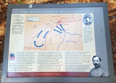
Once the sixth Corps completed its Breakthrough, corps commander Horatio wright ordered seven of his eight brigades to pivot southwest and move against the remaining Confederate defenses north of Hatcher’s Run. Wright assigned just one brigade, Colonel Joseph E. Hamblin’s, to reamin in this area and secure the ground captured during the Breakthrough.
Confederate division commander Major General Cadmus M. Wilcox reacted to the Breakthrough by organizing about 600 troops from Brigadier General James H. Lane's North Carolina Brigade and Brigadier General Edward L. Thomas’ Georgia Brigade to attempt to regain the lost lines. At the very least, Wilcox hoped to blunt any attempt to move against Petersburg until fresh Confederate troops could arrive from north of the Appomattox River.
Wilcox's counterattack drove elements of Hamblin's Pennsylvanians, New Yorkers, and Connecticut men back from their advanced positions to this vicinity. The Confederates established a thin line of defense along Church Road perpendicular to their old works, temporarily blocking any further Union advance. Later in the morning, however, the Sixth Corps, supported by other Union troops, returned to this area and compelled Wilcox’s men to retreat again. The stage was now set for the dramatic afternoon battle at Fort Gregg.
(captions)
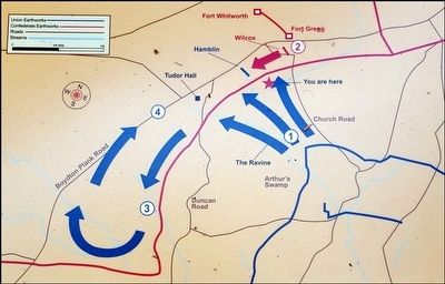
(upper left) The Confederate counterattack on the morning of April 2, 1865:
1. The extent of the Sixth Corps breakthrough.
2. Wilcox’s counterattack against Hamblin’s Brigade.
3. The Sixth Corps advance to Hatcher’s Run.
4. The Union advance toward Fort Gregg.
Check with any member of the park staff about how to visit Fort Gregg.
(upper right) Joseph Elbridge Hamblin, a 37-year-old native of Massachusetts, was popular with the men of his brigade. One admirer described him as “a brave officer of magnificent figure and bearing, and a gentleman by instinct.”
(lower right) Cadmus Marcellus Wilcox was a 40-year-old native of North Carolina. He commanded most of the troops victimized by the Sixth Corps Breakthrough, although during the attack Wilcox was at his headquarters several miles to the north.
Erected 2015 by Pamplin Historical Park.
Topics. This historical marker is listed in this topic list: War, US Civil. A significant historical date for this entry is April 2, 1865.
Location. 37° 11.067′ N, 77° 28.233′ W. Marker is in Petersburg, Virginia, in Dinwiddie County. Marker is on Duncan Road (Virginia Route 670) 0.7 miles south of Boydton Plank Road (U.S. 1), on the left when traveling south. Located on the Breakthrough Trail at Pamplin Historical Park. Touch for map. Marker is at or near this postal address: 6125 Boydton Plank Road, Petersburg VA 23803, United States of America. Touch for directions.
Other nearby markers. At least 8 other markers are within walking distance of this marker. The Breakthrough (about 300 feet away, measured in a direct line); “Our Line of Battle was so Thin” (about 800 feet away); “We Fought Desperately” (approx. 0.2 miles away); Lane’s North Carolina Brigade (approx. 0.2 miles away); 1st Lieutenant Evander McNair Robeson (approx. 0.2 miles away); Lieutenant Colonel Ronald A. Kennedy (approx. ¼ mile away); Battlefield Terrain (approx. ¼ mile away); “A Great Struggle is Now Impending” (approx. ¼ mile away). Touch for a list and map of all markers in Petersburg.
Also see . . . Pamplin Historical Park and The National Museum of the Civil War Soldier. (Submitted on October 19, 2015.)
Credits. This page was last revised on February 2, 2023. It was originally submitted on October 19, 2015, by Bernard Fisher of Richmond, Virginia. This page has been viewed 448 times since then and 21 times this year. Photos: 1, 2, 3. submitted on October 19, 2015, by Bernard Fisher of Richmond, Virginia.


