Shadyside in Pittsburgh in Allegheny County, Pennsylvania — The American Northeast (Mid-Atlantic)
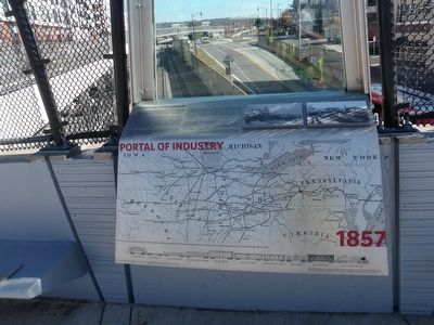
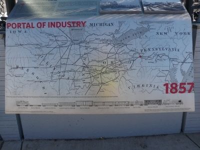
Portal of Industry
1857
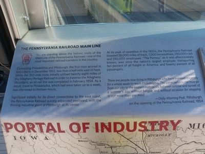
— The Pennsylvania Railroad Mainline —
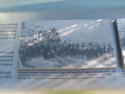
Connecting Philadelphia and Pittsburgh, the first train arrived in East Liberty in December 1852, less than a half mile east of here. While the 350-mile route initially utilized twenty-eight miles of the Allegheny Portage Railroad in order to traverse the Allegheny Mountains, an all-rail line was completed in February 1854. As a result, travel to Philadelphia, which had taken up to a week, was shortened to thirteen hours.
Significant initially for its direct connections to the east coast, the Pennsylvania Railroad quickly expanded westward, with the thriving industrial giant of Pittsburgh at its center.
At its peak of operation in the 1920s, the Pennsylvania Railroad boasted 28,000 miles of track, 7,000 locomotives, 250,000 cars and 280,000 employees. "The Pennsy," as it was affectionately known, was once the nation's largest employer, transporting ten percent of all freight in America, and twenty percent of all passengers.
There are people now living in Pittsburgh who have traveled diligently for a whole week to reach Philadelphia. The same persons can now go from our city to the eastern metropolis between sunrise and sunset of a summer's day, without fatigue, and without occasion for stopping to eat more than one meal.
—Daily Morning Post,Pittsburgh on the opening of the Pennsylvania Railroad, 1854
Erected 2013 by Federal Highway Administration, Pennsylvania Department of Transportation, City of Pittsburgh.
Topics. This historical marker is listed in these topic lists: Industry & Commerce • Railroads & Streetcars. A significant historical month for this entry is February 1854.
Location. 40° 27.551′ N, 79° 55.499′ W. Marker is in Pittsburgh, Pennsylvania, in Allegheny County. It is in Shadyside. Marker can be reached from South Highland Avenue, 0.1 miles south of Centre Avenue, on the left when traveling south. This marker is part of a display erected on the sidewalk parapet of the newly refurbished South Highland Avenue Bridge. Touch for map. Marker is in this post office area: Pittsburgh PA 15206, United States of America. Touch for directions.
Other nearby markers. At least 8 other markers are within walking distance of this marker. Suburban Catalyst (a few steps from this marker); Motor Square Garden (about 600 feet away, measured in a direct line); East Liberty Presbyterian Church (approx. 0.2 miles away); Calvary Episcopal Church (approx. ¼ mile away); Sacred Heart Church (approx. ¼ mile away); 1st Drive-In Filling Station (approx. 0.3 miles away); St. Peter's Evangelical and Reformed Church (approx. 0.3 miles away); The Highwood (approx. 0.3 miles away). Touch for a list and map of all markers in Pittsburgh.
Photographed By Mike Wintermantel, November 4, 2015
4. Portal of Industry Marker
(first photo)
Industrialists Andrew Carnegie and Henry Phipps and songwriter Stephen Foster were among the notables who welcomed the first through-train from Philadelphia to Pittsburgh in East Liberty in December 1852 (Library & Archives Division, Historical Society of Western Pennsylvania).
Industrialists Andrew Carnegie and Henry Phipps and songwriter Stephen Foster were among the notables who welcomed the first through-train from Philadelphia to Pittsburgh in East Liberty in December 1852 (Library & Archives Division, Historical Society of Western Pennsylvania).
Photographed By Mike Wintermantel, November 4, 2015
5. Portal of Industry Marker
(second photo)
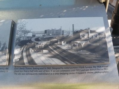
East Liberty Station, looking east in 1961. Designed by noted architect Frank Furness, the 1906 station stood less than a half mile east of here. It served commuters until 1953 and was demolished in 1963. The site was subsequently redeveloped as a strip shopping center (Edward H. Weber, photographer).
East Liberty Station, looking east in 1961. Designed by noted architect Frank Furness, the 1906 station stood less than a half mile east of here. It served commuters until 1953 and was demolished in 1963. The site was subsequently redeveloped as a strip shopping center (Edward H. Weber, photographer).
Credits. This page was last revised on February 2, 2023. It was originally submitted on November 5, 2015, by Mike Wintermantel of Pittsburgh, Pennsylvania. This page has been viewed 336 times since then and 23 times this year. Photos: 1, 2, 3, 4, 5, 6. submitted on November 5, 2015, by Mike Wintermantel of Pittsburgh, Pennsylvania.
