Lexington in Lafayette County, Missouri — The American Midwest (Upper Plains)
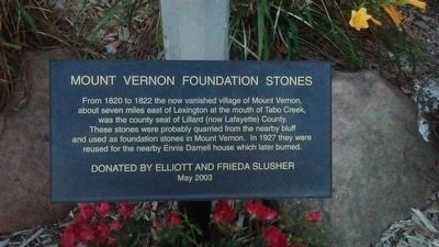
Mount Vernon Foundation Stones
Erected 2003.
Topics. This historical marker is listed in this topic list: Settlements & Settlers. A significant historical year for this entry is 1820.
Location. 39° 11.1′ N, 93° 52.785′ W. Marker is in Lexington, Missouri, in Lafayette County. Marker is on 13th Street, on the right when traveling north. This marker is located at the base of "The Library Building" marker in Lexington, Mo. Touch for map. Marker is in this post office area: Lexington MO 64067, United States of America. Touch for directions.
Other nearby markers. At least 8 other markers are within walking distance of this marker. The Library Building (here, next to this marker); Christ Church (within shouting distance of this marker); The Steamboat Saluda Disaster (within shouting distance of this marker); William Morrison (within shouting distance of this marker); Lexington (about 800 feet away, measured in a direct line); Lafayette County Courthouse (approx. 0.2 miles away); Wentworth World War Memorial (approx. 0.2 miles away); Replica of the Statue of Liberty (approx. 0.2 miles away). Touch for a list and map of all markers in Lexington.
Credits. This page was last revised on June 16, 2016. It was originally submitted on November 7, 2015, by Tom Bosse of Jefferson City, Tennessee. This page has been viewed 279 times since then and 9 times this year. Photo 1. submitted on November 7, 2015, by Tom Bosse of Jefferson City, Tennessee. • Bill Pfingsten was the editor who published this page.
