Fredericksburg, Virginia — The American South (Mid-Atlantic)
A History of Floods
Fredericksburg: Timeless.
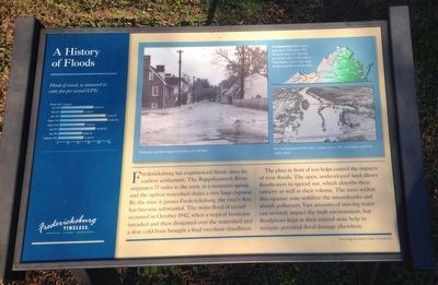
Fredericksburg has experienced floods since its earliest settlement. The Rappahannock River originates 77 miles to the west, in a mountain spring, and the upriver watershed drains a very large expanse. By the time is passes Fredericksburg, the river's flow has become substantial. the worst flood of record occurred in October 1942, when a tropical hurricane intruded and then dissipated over the watershed and a slow cold front brought a final two-hour cloudburst.
The plain in front of you helps control the impacts of river floods. The open, undeveloped land allows floodwaters to spread out, which absorbs their velocity as well as their volume. The trees within this riparian zone stabilize the stream banks and absorb pollutants. Vast amounts of moving water can severely impact the built environment, but floodplains kept in their natural state help to mitigate potential flood damage elsewhere.
Erected by Fredericksburg Economic Development and Tourism Office.
Topics and series. This historical marker is listed in these topic lists: Environment • Waterways & Vessels. In addition, it is included in the Virginia, Fredericksburg: Timeless. series list. A significant historical month for this entry is October 1942.
Location. 38° 19.067′ N, 77° 28.184′ W. Marker is in Fredericksburg, Virginia. Marker is at the intersection of Caroline Street and Forbes Street on Caroline Street. The marker is on the Fredericksburg Heritage Trail. Touch for map. Marker is in this post office area: Fredericksburg VA 22401, United States of America. Touch for directions.
Other nearby markers. At least 8 other markers are within walking distance of this marker. Bound for Freedom (within shouting distance of this marker); Killed in Action Memorials (about 500 feet away, measured in a direct line); Veterans of Foreign Wars Eternal Flame (about 500 feet away); Encounter at the Fall Line (about 600 feet away); Freedom Began Here (approx. ¼ mile away); Anthony Burns (approx. ¼ mile away); Moncure Daniel Conway (approx. ¼ mile away); Moncure Conway House (approx. ¼ mile away). Touch for a list and map of all markers in Fredericksburg.
More about this marker. The captions for the marker's pictures are:
Main picture:
Floodwaters flow down Fauquier Street during the 1942 flood.
Virginia map:
The Rappahannock River drains a watershed of 2,848 square miles. The upriver basin is 57 miles wide, but narrows to 10 miles wide at Fredericksburg, which is what makes the City susceptible to periodic floods.
Lower right photograph:
When the Rappahannock River floods, as shown here in 1942, its floodplains absorb the swollen waters.
On the left of the marker is a chart of, "Floods
Credits. This page was last revised on February 2, 2023. It was originally submitted on November 26, 2015, by Kevin W. of Stafford, Virginia. This page has been viewed 623 times since then and 90 times this year. Photos: 1. submitted on November 26, 2015, by Kevin W. of Stafford, Virginia. 2. submitted on May 3, 2020, by Devry Becker Jones of Washington, District of Columbia. 3. submitted on November 26, 2015, by Kevin W. of Stafford, Virginia.


