Buffalo in Johnson County, Wyoming — The American West (Mountains)
Fort McKinney
Inscription.
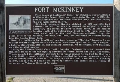
First known as Cantonment Reno, For McKinney was established in 1876 on the Powder River near present-day Jaycee. In 1877, the Fort was renamed for Lieutenant John McKinney, who died during the Dull Knife Battle in 1876.
The Fort's presence directly violated the 1851 and 1866 Fort Laramie Treaties. The Army determined the original site to be unsanitary and moved the Fort 45 miles north, to its current location south of here along Clear Creek in 1878. From here, the Army monitored the Sioux and Cheyenne activities, kept the peace between the Arapaho, Shoshone, and Crow, and protected the settlers moving into the Powder River Basin.
Here, Fort McKinney had 14 officer's quarters, known as "The Line." barracks for up to seven companies (approximately 1,400 men), laundresses' quarters, offices, a hospital, a bakery, storehouses, stables, and auxiliary buildings. Of the original fort buildings, only the hospital remains.
During the Johnson County War of 1892, President Benjamin Harrison ordered Fort McKinney troops to end the fighting between cattle barons and small landowners. Troops escorted the cattlemen and their hired Texas gunmen to the Fort for their own safety. Until it closed in 1894, Fort McKinney supplied the dominant economic stimulus for the nearby town of Buffalo. The Army deeded the land to the State of Wyoming in 1894, and in 1903, it became the Wyoming Soldiers' and Sailors' Home. Today it serves as the Veterans' Home of Wyoming.
Erected by Wyoming State Parks & Cultural Resources.
Topics and series. This historical marker is listed in this topic list: Forts and Castles. In addition, it is included in the Former U.S. Presidents: #23 Benjamin Harrison series list.
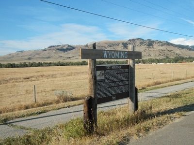
Location. 44° 20.34′ N, 106° 44.589′ W. Marker is in Buffalo, Wyoming, in Johnson County. Marker is on U.S. 16 at milepost 90 near Veterans Lane, on the left when traveling west. Touch for map. Marker is at or near this postal address: 8983 US Highway 16, Buffalo WY 82834, United States of America. Touch for directions.
Other nearby markers. At least 8 other markers are within 3 miles of this marker, measured as the crow flies. Veteran's Home of Wyoming War Memorials (approx. half a mile away); Greenbelt Trail–Klondike Access (approx. 1.8 miles away); Pelloux Bridge (approx. 2 miles away); Washington Park Trailhead (approx. 2.1 miles away); Nate Champion's Last Run (approx. 2.2 miles away); Homesteading and the Jenkins Family (approx. 2.2 miles away); Nate Champion's Diary (approx. 2.2 miles away); Occidental Hotel (approx. 2.2 miles away). Touch for a list and map of all markers in Buffalo.
More about this marker. This markers is approximately 0.3 miles west of the entrance to the Wyoming Soldier's and Sailor's Home.
Also see . . . Fort McKinney - WyoHIstory. Troops at Fort McKinney included as many as four companies of the black Ninth Cavalry in the 1880s. White and black troops alike were responsible for keeping the Lakota Sioux and Cheyenne from reverting to their old ways of life in a vast region, for preventing Crow and Shoshone tribes from resuming intermittent strife with tribal enemies... (Submitted on December 12, 2015, by Barry Swackhamer of Brentwood, California.)
Credits. This page was last revised on August 2, 2020. It was originally submitted on December 12, 2015, by Barry Swackhamer of Brentwood, California. This page has been viewed 573 times since then and 26 times this year. Photos: 1, 2. submitted on December 12, 2015, by Barry Swackhamer of Brentwood, California.

