Duck in Dare County, North Carolina — The American South (South Atlantic)
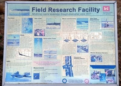
Field Research Facility
Advancing coastal knowledge through observation since 1977
Facilities
Welcome to the Field Research Facility (FRF). We were established in 1977 to conduct research to support the US Army Corps of Engineers coastal engineering mission. The FRF is recognized as one of the best places in the world to conduct coastal field studies. The facility is operated by a twelve-person staff known for their ability to collect data, design experiments and conduct research. Central to the FRF are the research pier, shore facilities, observation tower, and specialized vehicles.
CRAB
The CRAB (Coastal Research Amphibious Buggy) uses centimeter-level satellite positioning (GPS) to survey to -9 m (-30 ft) depth. It provides a stable platform for instrument deployments, sediment sampling, and towing sleds with oceanographic instruments. Mapping data collected with the CRAB provide a long-term, consistent measure of beach changes. The graph at right overplots 10 years of surveys. Note that most change occurs on the beach and just offshore.
The CRAB is popular, may have seen it on the Weather Channel, CNN, the Discovery Channel or read about it in the New York Times or National Geographic. It may even be out working today - if it is please don't get close.
LARC
The LARC (Lighter Amphibious Resupply Cargo) is a 4-wheel drive "boat" perfect for instrument deployments, dive operations, geophysical and hydrographic surveys. The LARC is equipped with GPS positioning and a digital depth sounder.
Pier & SIS
The concrete and steel pier extends 561 m (1840 ft) into the ocean at a height of 7.7 m (25.4 ft) above the water.
The Sensor Insertion System (SIS) is mounted on the pier and equipped with wave gauges, current meters, and sediment transport sensors.
The SIS can make measurements in 5-m (16 ft) waves and can reach out 15 m (50 ft) to deploy instruments anywhere along the pier.
With the SIS, previously unobtainable measurements of sand movement during major storm events have been collected.
Observation Tower
The 400 m-tall (130 ft) observation tower supports radio antennae and 8 video cameras. Working with Oregon State University scientists, innovative techniques have been developed for collecting ocean measurements from images. For example, the time exposure images below show the offshore movement of sandbars (areas in white) before and after a hurricane. You can check out the view from the tower on our web page.
Drop by our web site at: http://frf.usace.army.mil
Take a virtual tour, check out the live cameras, and keep track of the water temperature, the waves, and the beach.
Measurements
The FRF's measurement program is designed to measure the important physical parameters that impact the coast including:
• wind sped & direction
• atmospheric pressure, temperature, humidity, precipitation
• wave height, period & direction
• tide and water level
• current profile
• bathymetry
• water temperature, visibility, salinity
• aerial photography; hourly video images
Waves and Currents
Beach erosion is controlled by both wave height and direction. Waves arriving at a sharp angle to the shore move sand alongshore, while waves arriving parallel to the shore move sediments seaward. We use a number of techniques to measure waves. Our best is with 15 pressure sensors precisely located on the ocean bottom in 8-m (26 ft) of water. This array of sensors was installed in 1986 and is the world's most accurate and longest running directional wave sensor. Data collected during Hurricane Bonnie are shown below.
Since waves suspend sand and currents move the sand around, we use instruments like the one shown at right to measure waves and currents. A sonar, located in the middle of this frame, measures bottom changes. Measurements are real-time and are particularly interesting during storms when large bottom changes occur. These measurements, along with our other observations, are helping us to unravel the mystery of sediment transport and beach erosion.
Research Helping Others
Because of the data we've collected, our knowledge of the Duck beach and our unique capabilities (like the CRAB), many groups conduct experiments here.
We also support other US Army Corps of Engineer offices. Our surveying capabilities have been used from New York to California. Locally we have been creating maps of Oregon Inlet (shown left), which are being used to understand and quantify the dynamics of this important inlet. We also represent the Corps of Engineers in an effort with other agencies to collect useful coastal observations nationwide.
The Field Research Facility is a branch of the Coastal and Hydraulics Laboratory of the US Army's Engineer Research and Development Center.
Surf Zone Experiments
The capabilities of the FRF have attracted coastal research across the country and around the world. As a result, most large US nearshore field experiments have been conducted here. Given names like DUCK94, SUPERDUCK, and SandyDuck, these experiments have been cosponsored with the Office of Naval Research, and the US Geological Survey.
DELILAH, in 1990, provided a rich data set on surf zone waves and currents. The figure to the left shows a cross-section of the beach (circles show current meters). Note the offshore shift of the sandbar (from the red line to the black line) caused by a Nor’easter.
During DUCK94 and SandyDuck, in 1997, hundreds of sensors and instruments were deployed in the surf zone, on sleds pulled offshore, and from the pier.
Research conducted here expands our knowledge and understanding of the complicated processes acting along the coast. Our results are helping us design environmentally friendly and cost effective coastal projects, such as harbors and navigation channels. Our activities are also helping to enhance our armed forces capabilities for wartime and humanitarian operations wherever the ocean meets the land.
Marine Science Careers
If you're like us and love the ocean, are curious about the world around you, and enjoy a challenge, consider a career in marine science. We enjoy working outdoors and using our heads and computers to explore our data. Come visit. Take our summer tour or arrange a special tour for your class or civic group. Explore our web site.
Erected by US Army Corps of Engineers.
Topics. This historical marker is listed in these topic lists: Environment • Science & Medicine. A significant historical year for this entry is 1977.
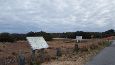
Location. 36° 10.861′ N, 75° 45.385′ W. Marker is in Duck, North Carolina, in Dare County. Marker is on Duck Road (State Highway 12) 0.3 miles north of Sandy Ridge Road East, on the right when traveling north. Touch for map. Marker is at or near this postal address: 1261 Duck Road, Kitty Hawk NC 27949, United States of America. Touch for directions.
Other nearby markers. At least 8 other markers are within 11 miles of this marker, measured as the crow flies. Powder Ridge Club (approx. ¾ mile away); Caffey's Inlet, U.S. Lifesaving Station No. 5 (approx. 3 miles away); Take a Boy Fishing in North Carolina (approx. 6.2 miles away); Monument to a Century of Flight (approx. 6.2 miles away); Thomas J. Jarvis (approx. 6.3 miles away); Currituck Sound (approx. 6.4 miles away); Wright Brothers' Memorial (approx. 8.8 miles away); Wreck Of The Metropolis (approx. 10.6 miles away). Touch for a list and map of all markers in Duck.
Credits. This page was last revised on April 28, 2022. It was originally submitted on December 22, 2015, by Bernard Fisher of Richmond, Virginia. This page has been viewed 726 times since then and 29 times this year. Photos: 1, 2, 3. submitted on December 22, 2015, by Bernard Fisher of Richmond, Virginia.


